You are here: Home > Network List > TA - USArray Transportable Network (new EarthScope stations) Stations List
> Station A07A Ashnola River, Keremeos, BC, Canada > Earthquake Result Viewer
A07A Ashnola River, Keremeos, BC, Canada - Earthquake Result Viewer
| Earthquake location: |
Near Coast Of Peru |
| Earthquake latitude/longitude: |
-13.6/-76.6 |
| Earthquake time(UTC): |
2007/08/17 (229) 13:18:13 GMT |
| Earthquake Depth: |
48 km |
| Earthquake Magnitude: |
5.6 MB, 5.6 MS, 5.9 MW |
| Earthquake Catalog/Contributor: |
WHDF/NEIC |
|
| Network: |
TA USArray Transportable Network (new EarthScope stations) |
| Station: |
A07A Ashnola River, Keremeos, BC, Canada |
| Lat/Lon: |
49.05 N/120.38 W |
| Elevation: |
1842 m |
|
| Distance: |
73.4 deg |
| Az: |
331.636 deg |
| Baz: |
135.408 deg |
| Ray Param: |
0.052943345 |
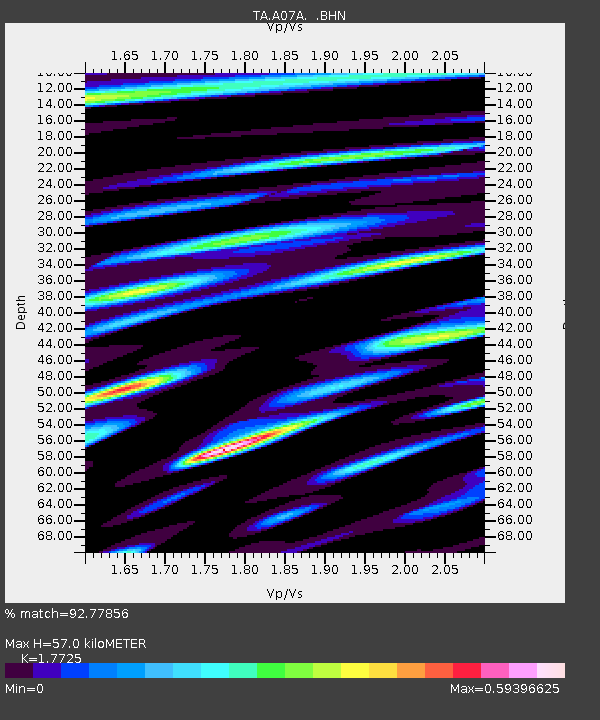
| Estimated Moho Depth: |
57.0 km |
| Estimated Crust Vp/Vs: |
1.77 |
| Assumed Crust Vp: |
6.566 km/s |
| Estimated Crust Vs: |
3.704 km/s |
| Estimated Crust Poisson's Ratio: |
0.27 |
|
| Radial Match: |
92.77856 % |
| Radial Bump: |
400 |
| Transverse Match: |
83.13204 % |
| Transverse Bump: |
400 |
| SOD ConfigId: |
2564 |
| Insert Time: |
2010-03-07 04:01:44.641 +0000 |
| GWidth: |
2.5 |
| Max Bumps: |
400 |
| Tol: |
0.001 |
|
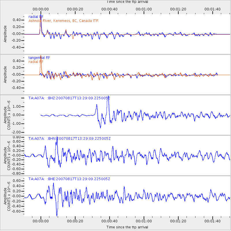
Signal To Noise
| Channel | StoN | STA | LTA |
| TA:A07A: :BHN:20070817T13:29:09.225005Z | 6.4740233 | 2.2791656E-7 | 3.5204778E-8 |
| TA:A07A: :BHE:20070817T13:29:09.225005Z | 3.8863752 | 1.7580217E-7 | 4.5235513E-8 |
| TA:A07A: :BHZ:20070817T13:29:09.225005Z | 11.1657915 | 6.5159423E-7 | 5.83563E-8 |
| Arrivals |
| Ps | 6.9 SECOND |
| PpPs | 23 SECOND |
| PsPs/PpSs | 30 SECOND |


