You are here: Home > Network List > TA - USArray Transportable Network (new EarthScope stations) Stations List
> Station A07A Ashnola River, Keremeos, BC, Canada > Earthquake Result Viewer
A07A Ashnola River, Keremeos, BC, Canada - Earthquake Result Viewer
| Earthquake location: |
Andreanof Islands, Aleutian Is. |
| Earthquake latitude/longitude: |
51.8/-176.3 |
| Earthquake time(UTC): |
2007/07/13 (194) 21:54:43 GMT |
| Earthquake Depth: |
35 km |
| Earthquake Magnitude: |
5.7 MB, 5.6 MS, 6.0 MW, 5.9 MW |
| Earthquake Catalog/Contributor: |
WHDF/NEIC |
|
| Network: |
TA USArray Transportable Network (new EarthScope stations) |
| Station: |
A07A Ashnola River, Keremeos, BC, Canada |
| Lat/Lon: |
49.05 N/120.38 W |
| Elevation: |
1842 m |
|
| Distance: |
35.0 deg |
| Az: |
71.912 deg |
| Baz: |
296.308 deg |
| Ray Param: |
0.07740349 |
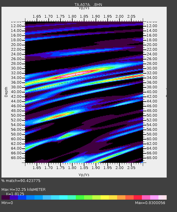
| Estimated Moho Depth: |
32.25 km |
| Estimated Crust Vp/Vs: |
1.81 |
| Assumed Crust Vp: |
6.566 km/s |
| Estimated Crust Vs: |
3.623 km/s |
| Estimated Crust Poisson's Ratio: |
0.28 |
|
| Radial Match: |
90.423775 % |
| Radial Bump: |
399 |
| Transverse Match: |
75.16484 % |
| Transverse Bump: |
400 |
| SOD ConfigId: |
2564 |
| Insert Time: |
2010-03-07 04:02:04.622 +0000 |
| GWidth: |
2.5 |
| Max Bumps: |
400 |
| Tol: |
0.001 |
|
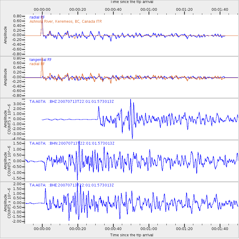
Signal To Noise
| Channel | StoN | STA | LTA |
| TA:A07A: :BHN:20070713T22:01:01.573013Z | 4.9506545 | 2.9238774E-7 | 5.9060422E-8 |
| TA:A07A: :BHE:20070713T22:01:01.573013Z | 20.012604 | 5.181371E-7 | 2.589054E-8 |
| TA:A07A: :BHZ:20070713T22:01:01.573013Z | 16.371677 | 8.997581E-7 | 5.4958214E-8 |
| Arrivals |
| Ps | 4.3 SECOND |
| PpPs | 13 SECOND |
| PsPs/PpSs | 17 SECOND |


