You are here: Home > Network List > TA - USArray Transportable Network (new EarthScope stations) Stations List
> Station A07A Ashnola River, Keremeos, BC, Canada > Earthquake Result Viewer
A07A Ashnola River, Keremeos, BC, Canada - Earthquake Result Viewer
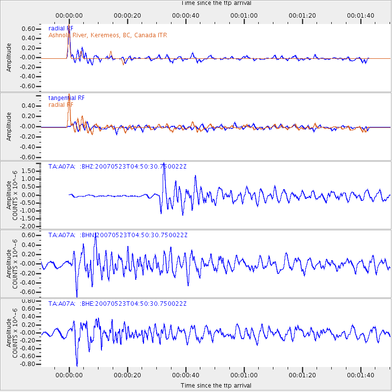
| Earthquake location: |
Northern Mid-Atlantic Ridge |
| Earthquake latitude/longitude: |
52.4/-31.8 |
| Earthquake time(UTC): |
2007/05/23 (143) 04:41:46 GMT |
| Earthquake Depth: |
10 km |
| Earthquake Magnitude: |
5.6 MS, 5.4 MB, 5.7 MW, 5.6 MW |
| Earthquake Catalog/Contributor: |
WHDF/NEIC |
|
| Network: |
TA USArray Transportable Network (new EarthScope stations) |
| Station: |
A07A Ashnola River, Keremeos, BC, Canada |
| Lat/Lon: |
49.05 N/120.38 W |
| Elevation: |
1842 m |
|
| Distance: |
52.8 deg |
| Az: |
304.316 deg |
| Baz: |
50.354 deg |
| Ray Param: |
0.06653909 |
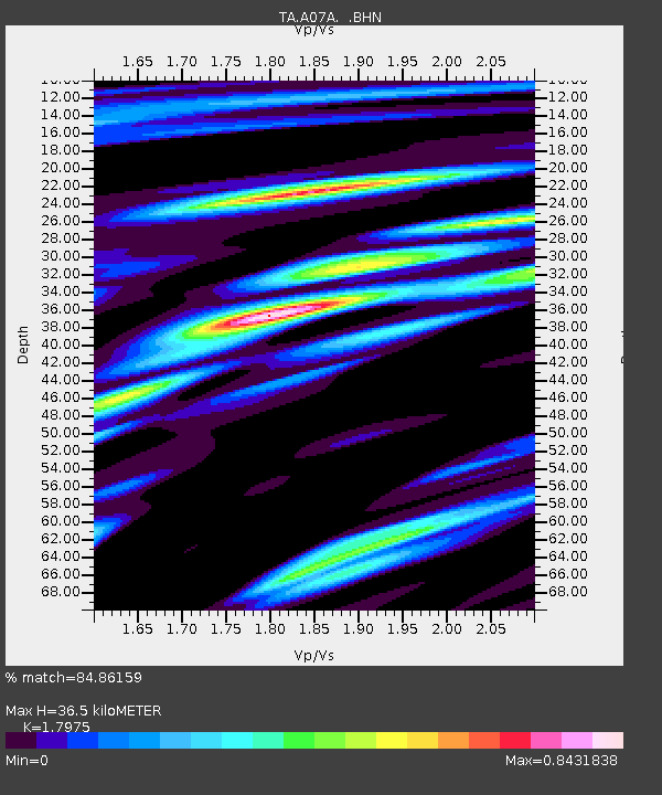
| Estimated Moho Depth: |
36.5 km |
| Estimated Crust Vp/Vs: |
1.80 |
| Assumed Crust Vp: |
6.566 km/s |
| Estimated Crust Vs: |
3.653 km/s |
| Estimated Crust Poisson's Ratio: |
0.28 |
|
| Radial Match: |
84.86159 % |
| Radial Bump: |
400 |
| Transverse Match: |
58.88649 % |
| Transverse Bump: |
400 |
| SOD ConfigId: |
2564 |
| Insert Time: |
2010-03-07 04:02:12.262 +0000 |
| GWidth: |
2.5 |
| Max Bumps: |
400 |
| Tol: |
0.001 |
|
Signal To Noise
| Channel | StoN | STA | LTA |
| TA:A07A: :BHN:20070523T04:50:30.750022Z | 2.4969642 | 2.41247E-7 | 9.661613E-8 |
| TA:A07A: :BHE:20070523T04:50:30.750022Z | 6.905028 | 2.8587124E-7 | 4.140045E-8 |
| TA:A07A: :BHZ:20070523T04:50:30.750022Z | 20.079514 | 7.406995E-7 | 3.6888316E-8 |
| Arrivals |
| Ps | 4.7 SECOND |
| PpPs | 15 SECOND |
| PsPs/PpSs | 19 SECOND |


