You are here: Home > Network List > TA - USArray Transportable Network (new EarthScope stations) Stations List
> Station A07A Ashnola River, Keremeos, BC, Canada > Earthquake Result Viewer
A07A Ashnola River, Keremeos, BC, Canada - Earthquake Result Viewer
| Earthquake location: |
Solomon Islands |
| Earthquake latitude/longitude: |
-8.5/157.0 |
| Earthquake time(UTC): |
2007/04/01 (091) 20:39:56 GMT |
| Earthquake Depth: |
10 km |
| Earthquake Magnitude: |
6.8 MB, 7.9 MS, 8.1 MW, 7.7 ME |
| Earthquake Catalog/Contributor: |
WHDF/NEIC |
|
| Network: |
TA USArray Transportable Network (new EarthScope stations) |
| Station: |
A07A Ashnola River, Keremeos, BC, Canada |
| Lat/Lon: |
49.05 N/120.38 W |
| Elevation: |
1842 m |
|
| Distance: |
91.5 deg |
| Az: |
40.74 deg |
| Baz: |
258.899 deg |
| Ray Param: |
0.04159866 |
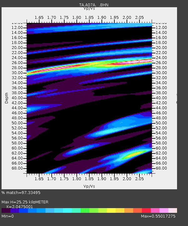
| Estimated Moho Depth: |
25.25 km |
| Estimated Crust Vp/Vs: |
2.05 |
| Assumed Crust Vp: |
6.566 km/s |
| Estimated Crust Vs: |
3.207 km/s |
| Estimated Crust Poisson's Ratio: |
0.34 |
|
| Radial Match: |
97.33495 % |
| Radial Bump: |
359 |
| Transverse Match: |
91.4593 % |
| Transverse Bump: |
400 |
| SOD ConfigId: |
2564 |
| Insert Time: |
2010-03-07 04:02:14.476 +0000 |
| GWidth: |
2.5 |
| Max Bumps: |
400 |
| Tol: |
0.001 |
|
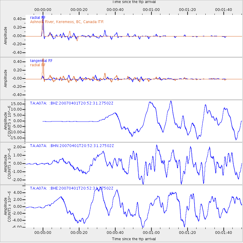
Signal To Noise
| Channel | StoN | STA | LTA |
| TA:A07A: :BHN:20070401T20:52:31.27502Z | 0.77504754 | 5.851335E-8 | 7.5496466E-8 |
| TA:A07A: :BHE:20070401T20:52:31.27502Z | 4.402443 | 5.00531E-7 | 1.13693915E-7 |
| TA:A07A: :BHZ:20070401T20:52:31.27502Z | 13.780831 | 1.5190064E-6 | 1.1022604E-7 |
| Arrivals |
| Ps | 4.1 SECOND |
| PpPs | 12 SECOND |
| PsPs/PpSs | 16 SECOND |


