You are here: Home > Network List > TA - USArray Transportable Network (new EarthScope stations) Stations List
> Station L02A Cave Junction, OR, USA > Earthquake Result Viewer
L02A Cave Junction, OR, USA - Earthquake Result Viewer
| Earthquake location: |
Northern Chile |
| Earthquake latitude/longitude: |
-22.2/-69.9 |
| Earthquake time(UTC): |
2007/11/14 (318) 15:40:50 GMT |
| Earthquake Depth: |
40 km |
| Earthquake Magnitude: |
6.7 MB, 7.4 MS, 7.7 MW, 7.4 ME |
| Earthquake Catalog/Contributor: |
WHDF/NEIC |
|
| Network: |
TA USArray Transportable Network (new EarthScope stations) |
| Station: |
L02A Cave Junction, OR, USA |
| Lat/Lon: |
42.16 N/123.60 W |
| Elevation: |
485 m |
|
| Distance: |
81.0 deg |
| Az: |
322.643 deg |
| Baz: |
130.886 deg |
| Ray Param: |
0.047813736 |
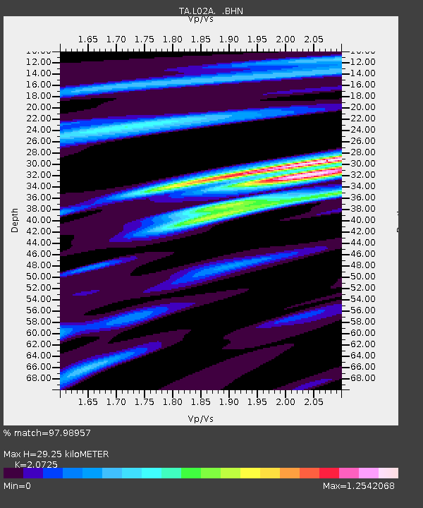
| Estimated Moho Depth: |
29.25 km |
| Estimated Crust Vp/Vs: |
2.07 |
| Assumed Crust Vp: |
6.522 km/s |
| Estimated Crust Vs: |
3.147 km/s |
| Estimated Crust Poisson's Ratio: |
0.35 |
|
| Radial Match: |
97.98957 % |
| Radial Bump: |
313 |
| Transverse Match: |
90.53029 % |
| Transverse Bump: |
400 |
| SOD ConfigId: |
2564 |
| Insert Time: |
2010-03-07 04:03:37.808 +0000 |
| GWidth: |
2.5 |
| Max Bumps: |
400 |
| Tol: |
0.001 |
|
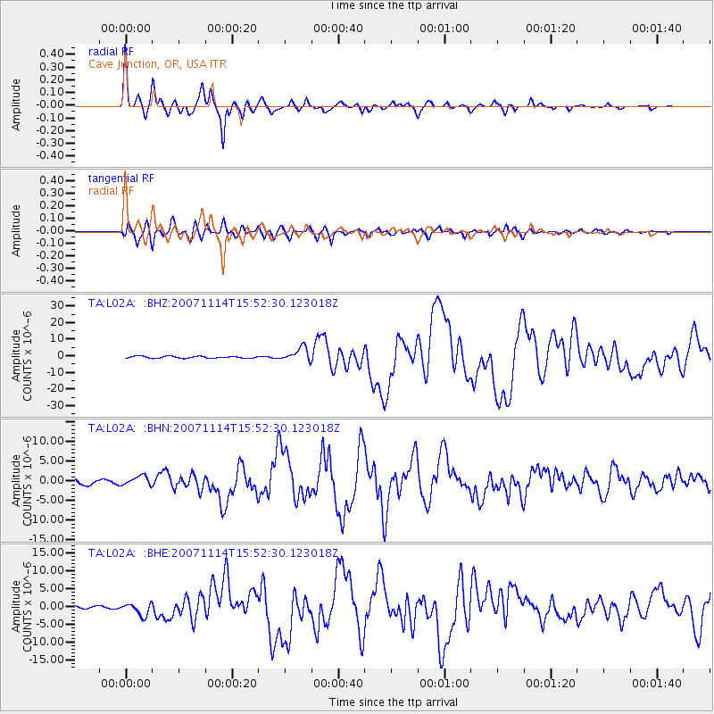
Signal To Noise
| Channel | StoN | STA | LTA |
| TA:L02A: :BHN:20071114T15:52:30.123018Z | 1.8468308 | 1.1944152E-6 | 6.4673776E-7 |
| TA:L02A: :BHE:20071114T15:52:30.123018Z | 3.2771876 | 1.7376661E-6 | 5.302309E-7 |
| TA:L02A: :BHZ:20071114T15:52:30.123018Z | 7.143676 | 4.1789604E-6 | 5.849874E-7 |
| Arrivals |
| Ps | 4.9 SECOND |
| PpPs | 13 SECOND |
| PsPs/PpSs | 18 SECOND |


