
Station TA L02A - Cave Junction, OR, USA
Network: TA - USArray Transportable Network (new EarthScope stations)
Nearby stations (2 deg radius)
| Station | Name | (Lat, Lon) | Start / End | Elevation |
| L02A | Cave Junction, OR, USA | (42.16, -123.60) | 2005-12-16 / 2499-01-01 | 0.5 km |
| Crust2 Type: | LC,continental arc, Cordilleras, 1.0 km seds. |
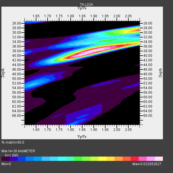
| Thickness Estimate: | 38 km |
| Thickness StdDev: | 3.4 km |
| Vp/Vs Estimate: | 1.89 |
| Vp/Vs StdDev: | 0.08 |
| Vs Estimate: | 3.441 km/s |
| Poisson's Ratio: | 0.31 |
| Peak Value: | 0.03 |
| Assumed Vp: | 6.522 km/s |
| Ps Weight: | 0.33333334 |
| PpPs Weight: | 0.33333334 |
| PsPs Weight: | 0.33333328 |
| Residual Complexity: | 0.659 |
| Nearby stations H: | +- |
| (2.0 deg) Vp/Vs: | +- |
11 with match > 90% ( 33.333332 %) and 33 with match > 80% ( 100.0 %) out of 33.
Download stack as xyz text file.
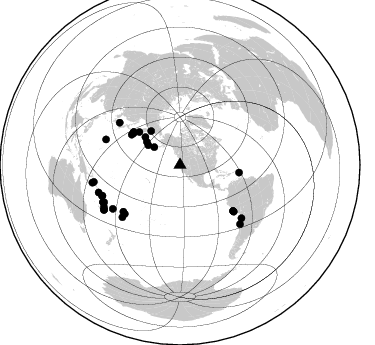
Azimuth Distribution of Events:
Prior Results for this Station
| Study | Thickness | Vp/Vs | Vp | Vs | Poissons Ratio | Extra |
| EARS | 38 km | 1.89 | 6.522 km/s | 3.441 km/s | 0.31 | |
| Crust2.0 | 37 km | 1.77 | 6.522 km/s | 3.676 km/s | 0.27 | LC,continental arc, Cordilleras, 1.0 km seds. |
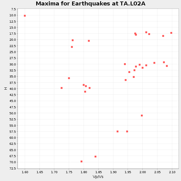
| Global Maxima | 38 km | 1.89 | 6.522 km/s | 3.441 km/s | 0.31 | amp=0.032852627 |
| Local Maxima 1 | 29 km | 2.10 | 6.522 km/s | 3.113 km/s | 0.35 | amp=0.025444344 |
| Local Maxima 2 | 40 km | 1.82 | 6.522 km/s | 3.593 km/s | 0.28 | amp=0.020943236 |
| Local Maxima 3 | 35 km | 2.02 | 6.522 km/s | 3.233 km/s | 0.34 | amp=0.019048776 |
| Local Maxima 4 | 28 km | 2.09 | 6.522 km/s | 3.12 km/s | 0.35 | amp=0.013623341 |
| Predicted Arrivals for vertical incidence (zero ray parameter) | |
| Ps | 5.21 SECOND |
| PpPs | 16.87 SECOND |
| PsPs/PpSs | 22.08 SECOND |
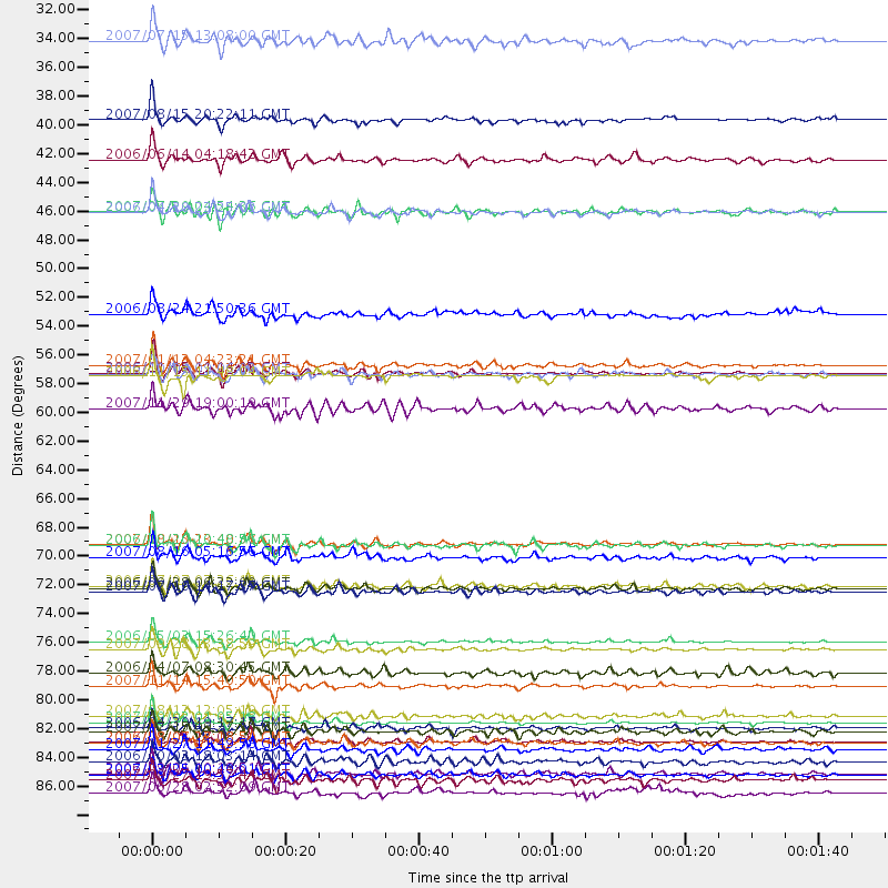
Events Processed for this Station
Download zip of receiver functions as SAC
Plot maxima for each earthquake.
Events Used in the Stack
(33 events)| Radial Match | Distance | Baz | FERegion | Time | Lat/Lon | Depth | Magnitude |
| 98.17514 | 56.9 deg | 305.219 deg | Kuril Islands | 2006/11/15 11:14:13 GMT | (46.6, 153.3) | 10 km | 6.5 MB, 7.8 MS, 8.3 MW, 7.9 MW |
| 97.98957 | 81.0 deg | 130.886 deg | Northern Chile | 2007/11/14 15:40:50 GMT | (-22.2, -69.9) | 40 km | 6.7 MB, 7.4 MS, 7.7 MW, 7.4 ME |
| 96.49454 | 83.8 deg | 248.404 deg | Santa Cruz Islands | 2007/09/02 01:05:18 GMT | (-11.6, 165.8) | 35 km | 5.9 MB, 7.3 MS, 7.2 MW, 6.9 ME |
| 96.28095 | 77.6 deg | 227.93 deg | Tonga Islands | 2006/05/03 15:26:40 GMT | (-20.2, -174.1) | 55 km | 7.2 MB, 7.8 MS, 7.9 MW, 7.9 MW |
| 95.525734 | 56.3 deg | 304.36 deg | East Of Kuril Islands | 2007/01/13 04:23:21 GMT | (46.2, 154.5) | 10 km | 7.3 MB, 8.2 MS, 8.1 MW, 7.9 MW |
| 95.21314 | 85.3 deg | 244.28 deg | Vanuatu Islands | 2007/08/01 17:08:51 GMT | (-15.6, 167.7) | 120 km | 6.2 MB, 7.2 MW, 7.2 MW |
| 94.97855 | 73.5 deg | 228.422 deg | Samoa Islands Region | 2006/09/28 06:22:09 GMT | (-16.6, -172.0) | 28 km | 6.5 MB, 6.6 MS, 6.9 MW, 6.7 MW |
| 93.94957 | 85.4 deg | 244.071 deg | Vanuatu Islands | 2006/08/07 22:18:54 GMT | (-15.8, 167.8) | 141 km | 6.0 MB, 6.8 MW, 6.8 MW |
| 93.77794 | 78.2 deg | 288.927 deg | Volcano Islands, Japan Region | 2007/09/28 13:38:59 GMT | (22.0, 142.7) | 276 km | 6.7 MB, 7.4 MW, 7.4 MW |
| 93.478134 | 70.1 deg | 130.824 deg | Near Coast Of Peru | 2007/08/15 23:40:57 GMT | (-13.4, -76.6) | 39 km | 6.7 MB, 7.9 MS, 8.0 MW, 7.5 ME |
| 90.637924 | 57.2 deg | 302.04 deg | East Of Kuril Islands | 2006/11/15 11:48:04 GMT | (44.1, 154.7) | 10 km | 5.5 MB |
| 89.33845 | 87.8 deg | 239.671 deg | Vanuatu Islands | 2007/03/25 00:40:01 GMT | (-20.6, 169.4) | 34 km | 6.5 MB, 7.0 MS, 7.1 MW, 7.1 MW |
| 89.00375 | 70.2 deg | 130.93 deg | Near Coast Of Peru | 2006/10/20 10:48:56 GMT | (-13.5, -76.7) | 23 km | 5.9 MB, 6.6 MS, 6.7 MW, 6.6 MW |
| 88.52974 | 59.6 deg | 97.264 deg | Windward Islands | 2007/11/29 19:00:19 GMT | (15.0, -61.3) | 148 km | 6.9 MB, 7.4 MW, 7.4 MW |
| 87.64361 | 87.8 deg | 258.915 deg | Solomon Islands | 2006/09/01 10:18:51 GMT | (-6.8, 155.5) | 38 km | 6.3 MB, 6.7 MS, 6.8 MW, 6.7 MW |
| 87.43675 | 84.6 deg | 243.787 deg | Vanuatu Islands | 2007/07/15 09:27:34 GMT | (-15.4, 168.6) | 8.0 km | 6.0 MB, 5.8 MS, 6.1 MW, 6.0 MW |
| 87.04422 | 73.8 deg | 305.02 deg | Sea Of Japan | 2007/07/16 14:17:37 GMT | (36.8, 134.9) | 350 km | 6.2 MB, 6.8 MW, 6.8 MW |
| 86.84712 | 80.0 deg | 236.98 deg | Fiji Islands Region | 2006/04/07 08:30:45 GMT | (-16.5, 177.0) | 22 km | 5.9 MB, 6.4 MS, 6.4 MW, 6.4 MW |
| 86.498695 | 40.6 deg | 304.711 deg | Rat Islands, Aleutian Islands | 2006/06/14 04:18:42 GMT | (51.8, 177.1) | 14 km | 5.9 MB, 6.4 MS, 6.4 MW, 6.4 MW |
| 86.395615 | 37.5 deg | 301.569 deg | Andreanof Islands, Aleutian Is. | 2007/08/15 20:22:11 GMT | (50.3, -177.5) | 9.0 km | 6.3 MB, 6.2 MS, 6.4 MW, 5.9 ML |
| 85.56761 | 31.4 deg | 304.676 deg | Fox Islands, Aleutian Islands | 2007/07/15 13:08:00 GMT | (52.5, -168.0) | 10 km | 5.8 MB, 5.9 MS, 6.1 MW, 6.0 MW |
| 85.41803 | 84.2 deg | 134.542 deg | Near Coast Of Northern Chile | 2006/04/30 19:17:17 GMT | (-27.0, -71.0) | 27 km | 6.0 MB, 6.4 MS, 6.7 MW, 6.6 MW |
| 84.84068 | 88.2 deg | 239.39 deg | Southeast Of Loyalty Islands | 2007/09/27 19:57:44 GMT | (-21.1, 169.3) | 9.0 km | 6.2 MB, 6.3 MS, 6.1 MW, 6.1 MW |
| 84.75061 | 85.9 deg | 251.373 deg | Solomon Islands | 2007/11/27 11:49:58 GMT | (-10.9, 162.1) | 16 km | 5.9 MB, 6.7 MS, 6.6 MW, 6.4 MW |
| 84.612885 | 89.2 deg | 258.624 deg | Solomon Islands | 2007/06/28 02:52:09 GMT | (-8.0, 154.6) | 10 km | 6.3 MB, 6.7 MS, 6.7 MW, 6.7 MW |
| 84.54424 | 73.3 deg | 230.524 deg | Tonga Islands | 2006/07/07 07:26:12 GMT | (-15.2, -173.6) | 35 km | 5.7 MB, 5.9 MS, 6.0 MW, 6.0 MW |
| 84.54306 | 52.4 deg | 308.764 deg | Near East Coast Of Kamchatka | 2006/08/24 21:50:36 GMT | (51.1, 157.5) | 43 km | 5.9 MB, 6.2 MS, 6.5 MW, 6.5 MW |
| 84.4822 | 57.0 deg | 305.101 deg | Kuril Islands | 2006/10/01 09:06:02 GMT | (46.5, 153.2) | 19 km | 6.1 MB, 6.4 MS, 6.6 MW, 6.5 MW |
| 84.46349 | 86.8 deg | 241.108 deg | Vanuatu Islands | 2006/10/03 18:03:14 GMT | (-18.9, 169.0) | 171 km | 5.9 MB, 6.3 MW, 6.3 MW |
| 84.39417 | 71.1 deg | 130.97 deg | Near Coast Of Peru | 2007/08/16 05:16:56 GMT | (-14.3, -76.1) | 23 km | 5.8 MB, 6.1 MS, 6.3 MW, 6.2 ML |
| 84.05104 | 44.6 deg | 308.812 deg | Komandorskiye Ostrova Region | 2007/07/29 04:54:36 GMT | (53.6, 169.7) | 26 km | 6.0 MB, 5.5 MS, 5.9 MW, 5.8 MW |
| 83.23699 | 44.6 deg | 319.45 deg | Eastern Siberia, Russia | 2006/04/20 23:25:02 GMT | (60.9, 167.1) | 22 km | 6.8 MB, 7.6 MS, 7.6 MW, 7.3 MW |
| 81.36936 | 83.3 deg | 248.21 deg | Santa Cruz Islands | 2007/08/12 12:05:19 GMT | (-11.4, 166.3) | 42 km | 5.8 MB, 5.7 MS, 6.0 MW, 6.0 MW |
Losers
(0 events)| Radial Match | Distance | Baz | FERegion | Time | Lat/Lon | Depth | Magnitude | Reason |
