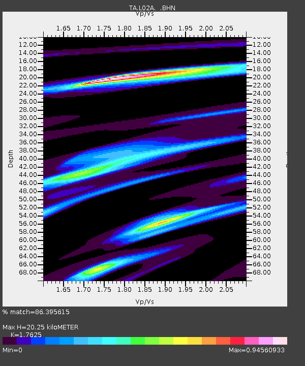
L02A Cave Junction, OR, USA - Earthquake Result Viewer
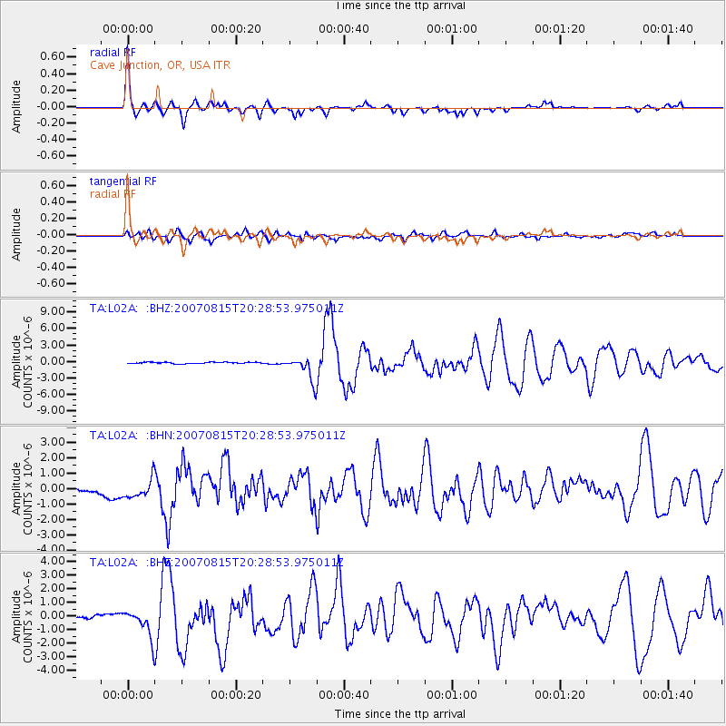
Earthquake location: Andreanof Islands, Aleutian Is.
Earthquake latitude/longitude: 50.3/-177.5
Earthquake time(UTC): 2007/08/15 (227) 20:22:11 GMT
Earthquake Depth: 9.0 km
Earthquake Magnitude: 6.3 MB, 6.2 MS, 6.4 MW, 5.9 ML
Earthquake Catalog/Contributor: WHDF/NEIC
Network: TA USArray Transportable Network (new EarthScope stations)
Station: L02A Cave Junction, OR, USA
Lat/Lon: 42.16 N/123.60 W
Elevation: 485 m
Distance: 37.5 deg
Az: 81.23 deg
Baz: 301.569 deg
Ray Param: 0.07612455
Estimated Moho Depth: 20.25 km
Estimated Crust Vp/Vs: 1.76
Assumed Crust Vp: 6.522 km/s
Estimated Crust Vs: 3.7 km/s
Estimated Crust Poisson's Ratio: 0.26
Radial Match: 86.395615 %
Radial Bump: 365
Transverse Match: 64.21841 %
Transverse Bump: 400
SOD ConfigId: 2564
Insert Time: 2010-03-07 04:03:46.715 +0000
GWidth: 2.5
Max Bumps: 400
Tol: 0.001

Signal To Noise

ChannelStoNSTALTA
TA:L02A: :BHN:20070815T20:28:53.975011Z1.82177195.874013E-73.2243406E-7
TA:L02A: :BHE:20070815T20:28:53.975011Z5.0276161.1420033E-62.2714609E-7
TA:L02A: :BHZ:20070815T20:28:53.975011Z17.1766592.2242305E-61.2949147E-7
Arrivals
Ps2.6 SECOND
PpPs7.9 SECOND
PsPs/PpSs11 SECOND