You are here: Home > Network List > TA - USArray Transportable Network (new EarthScope stations) Stations List
> Station L02A Cave Junction, OR, USA > Earthquake Result Viewer
L02A Cave Junction, OR, USA - Earthquake Result Viewer
| Earthquake location: |
Santa Cruz Islands |
| Earthquake latitude/longitude: |
-11.4/166.3 |
| Earthquake time(UTC): |
2007/08/12 (224) 12:05:19 GMT |
| Earthquake Depth: |
42 km |
| Earthquake Magnitude: |
5.8 MB, 5.7 MS, 6.0 MW, 6.0 MW |
| Earthquake Catalog/Contributor: |
WHDF/NEIC |
|
| Network: |
TA USArray Transportable Network (new EarthScope stations) |
| Station: |
L02A Cave Junction, OR, USA |
| Lat/Lon: |
42.16 N/123.60 W |
| Elevation: |
485 m |
|
| Distance: |
83.3 deg |
| Az: |
44.756 deg |
| Baz: |
248.21 deg |
| Ray Param: |
0.046225954 |
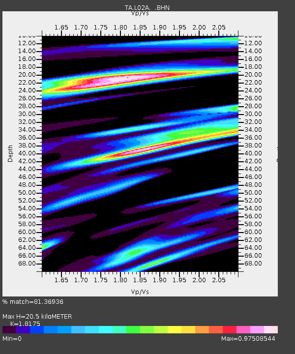
| Estimated Moho Depth: |
20.5 km |
| Estimated Crust Vp/Vs: |
1.82 |
| Assumed Crust Vp: |
6.522 km/s |
| Estimated Crust Vs: |
3.588 km/s |
| Estimated Crust Poisson's Ratio: |
0.28 |
|
| Radial Match: |
81.36936 % |
| Radial Bump: |
400 |
| Transverse Match: |
73.85643 % |
| Transverse Bump: |
400 |
| SOD ConfigId: |
2564 |
| Insert Time: |
2010-03-07 04:03:52.433 +0000 |
| GWidth: |
2.5 |
| Max Bumps: |
400 |
| Tol: |
0.001 |
|
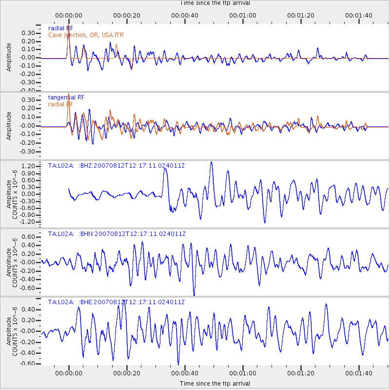
Signal To Noise
| Channel | StoN | STA | LTA |
| TA:L02A: :BHN:20070812T12:17:11.024011Z | 1.5451374 | 1.1957367E-7 | 7.738708E-8 |
| TA:L02A: :BHE:20070812T12:17:11.024011Z | 3.0953555 | 2.1712079E-7 | 7.0144054E-8 |
| TA:L02A: :BHZ:20070812T12:17:11.024011Z | 5.113497 | 5.409533E-7 | 1.0578931E-7 |
| Arrivals |
| Ps | 2.6 SECOND |
| PpPs | 8.6 SECOND |
| PsPs/PpSs | 11 SECOND |


