You are here: Home > Network List > TA - USArray Transportable Network (new EarthScope stations) Stations List
> Station L02A Cave Junction, OR, USA > Earthquake Result Viewer
L02A Cave Junction, OR, USA - Earthquake Result Viewer
| Earthquake location: |
Vanuatu Islands |
| Earthquake latitude/longitude: |
-15.6/167.7 |
| Earthquake time(UTC): |
2007/08/01 (213) 17:08:51 GMT |
| Earthquake Depth: |
120 km |
| Earthquake Magnitude: |
6.2 MB, 7.2 MW, 7.2 MW |
| Earthquake Catalog/Contributor: |
WHDF/NEIC |
|
| Network: |
TA USArray Transportable Network (new EarthScope stations) |
| Station: |
L02A Cave Junction, OR, USA |
| Lat/Lon: |
42.16 N/123.60 W |
| Elevation: |
485 m |
|
| Distance: |
85.3 deg |
| Az: |
44.04 deg |
| Baz: |
244.28 deg |
| Ray Param: |
0.04457889 |
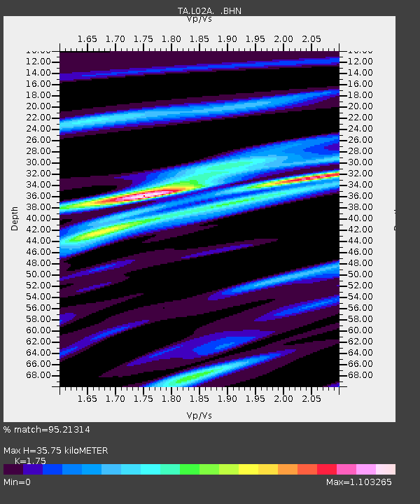
| Estimated Moho Depth: |
35.75 km |
| Estimated Crust Vp/Vs: |
1.75 |
| Assumed Crust Vp: |
6.522 km/s |
| Estimated Crust Vs: |
3.727 km/s |
| Estimated Crust Poisson's Ratio: |
0.26 |
|
| Radial Match: |
95.21314 % |
| Radial Bump: |
325 |
| Transverse Match: |
80.8169 % |
| Transverse Bump: |
400 |
| SOD ConfigId: |
2564 |
| Insert Time: |
2010-03-07 04:03:54.567 +0000 |
| GWidth: |
2.5 |
| Max Bumps: |
400 |
| Tol: |
0.001 |
|
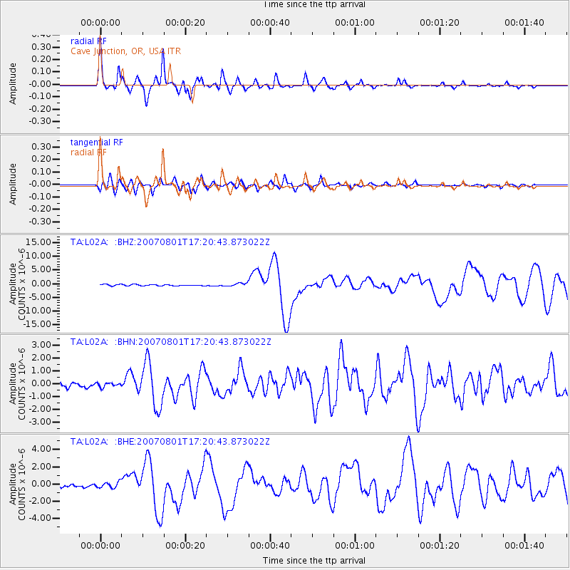
Signal To Noise
| Channel | StoN | STA | LTA |
| TA:L02A: :BHN:20070801T17:20:43.873022Z | 0.7092726 | 1.6934426E-7 | 2.3875765E-7 |
| TA:L02A: :BHE:20070801T17:20:43.873022Z | 1.726624 | 3.4256766E-7 | 1.9840316E-7 |
| TA:L02A: :BHZ:20070801T17:20:43.873022Z | 2.4479315 | 6.073633E-7 | 2.4811285E-7 |
| Arrivals |
| Ps | 4.2 SECOND |
| PpPs | 15 SECOND |
| PsPs/PpSs | 19 SECOND |


