You are here: Home > Network List > TA - USArray Transportable Network (new EarthScope stations) Stations List
> Station L02A Cave Junction, OR, USA > Earthquake Result Viewer
L02A Cave Junction, OR, USA - Earthquake Result Viewer
| Earthquake location: |
Vanuatu Islands |
| Earthquake latitude/longitude: |
-15.4/168.6 |
| Earthquake time(UTC): |
2007/07/15 (196) 09:27:34 GMT |
| Earthquake Depth: |
8.0 km |
| Earthquake Magnitude: |
6.0 MB, 5.8 MS, 6.1 MW, 6.0 MW |
| Earthquake Catalog/Contributor: |
WHDF/NEIC |
|
| Network: |
TA USArray Transportable Network (new EarthScope stations) |
| Station: |
L02A Cave Junction, OR, USA |
| Lat/Lon: |
42.16 N/123.60 W |
| Elevation: |
485 m |
|
| Distance: |
84.6 deg |
| Az: |
43.753 deg |
| Baz: |
243.787 deg |
| Ray Param: |
0.0453956 |
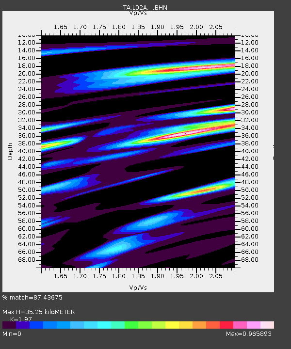
| Estimated Moho Depth: |
35.25 km |
| Estimated Crust Vp/Vs: |
1.97 |
| Assumed Crust Vp: |
6.522 km/s |
| Estimated Crust Vs: |
3.31 km/s |
| Estimated Crust Poisson's Ratio: |
0.33 |
|
| Radial Match: |
87.43675 % |
| Radial Bump: |
400 |
| Transverse Match: |
73.104904 % |
| Transverse Bump: |
400 |
| SOD ConfigId: |
2564 |
| Insert Time: |
2010-03-07 04:04:00.939 +0000 |
| GWidth: |
2.5 |
| Max Bumps: |
400 |
| Tol: |
0.001 |
|
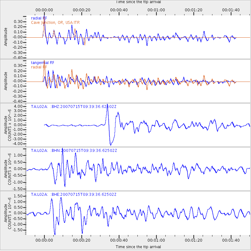
Signal To Noise
| Channel | StoN | STA | LTA |
| TA:L02A: :BHN:20070715T09:39:36.62502Z | 2.4777172 | 1.8954006E-7 | 7.6497855E-8 |
| TA:L02A: :BHE:20070715T09:39:36.62502Z | 6.969566 | 5.1960143E-7 | 7.455291E-8 |
| TA:L02A: :BHZ:20070715T09:39:36.62502Z | 18.37969 | 1.6056526E-6 | 8.7360156E-8 |
| Arrivals |
| Ps | 5.4 SECOND |
| PpPs | 16 SECOND |
| PsPs/PpSs | 21 SECOND |


