You are here: Home > Network List > TA - USArray Transportable Network (new EarthScope stations) Stations List
> Station L02A Cave Junction, OR, USA > Earthquake Result Viewer
L02A Cave Junction, OR, USA - Earthquake Result Viewer
| Earthquake location: |
East Of Kuril Islands |
| Earthquake latitude/longitude: |
46.2/154.5 |
| Earthquake time(UTC): |
2007/01/13 (013) 04:23:21 GMT |
| Earthquake Depth: |
10 km |
| Earthquake Magnitude: |
7.3 MB, 8.2 MS, 8.1 MW, 7.9 MW |
| Earthquake Catalog/Contributor: |
WHDF/NEIC |
|
| Network: |
TA USArray Transportable Network (new EarthScope stations) |
| Station: |
L02A Cave Junction, OR, USA |
| Lat/Lon: |
42.16 N/123.60 W |
| Elevation: |
485 m |
|
| Distance: |
56.3 deg |
| Az: |
62.181 deg |
| Baz: |
304.36 deg |
| Ray Param: |
0.06420988 |
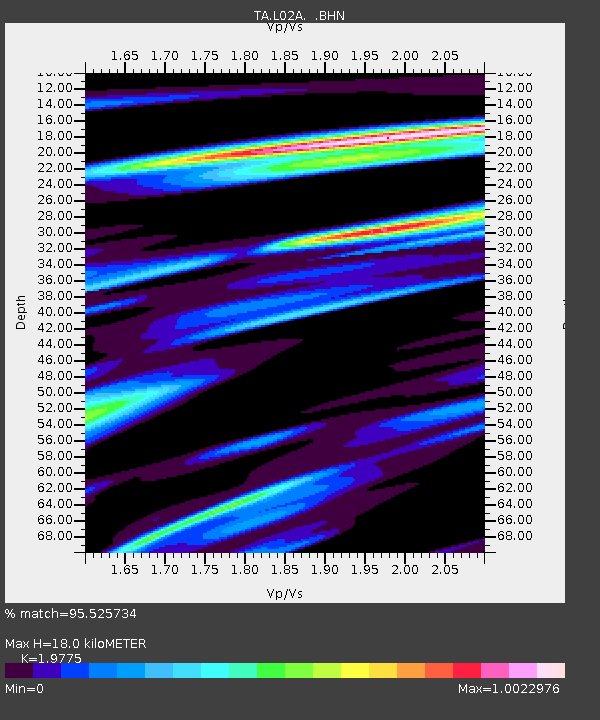
| Estimated Moho Depth: |
18.0 km |
| Estimated Crust Vp/Vs: |
1.98 |
| Assumed Crust Vp: |
6.522 km/s |
| Estimated Crust Vs: |
3.298 km/s |
| Estimated Crust Poisson's Ratio: |
0.33 |
|
| Radial Match: |
95.525734 % |
| Radial Bump: |
400 |
| Transverse Match: |
83.650475 % |
| Transverse Bump: |
400 |
| SOD ConfigId: |
2564 |
| Insert Time: |
2010-03-07 04:04:06.328 +0000 |
| GWidth: |
2.5 |
| Max Bumps: |
400 |
| Tol: |
0.001 |
|
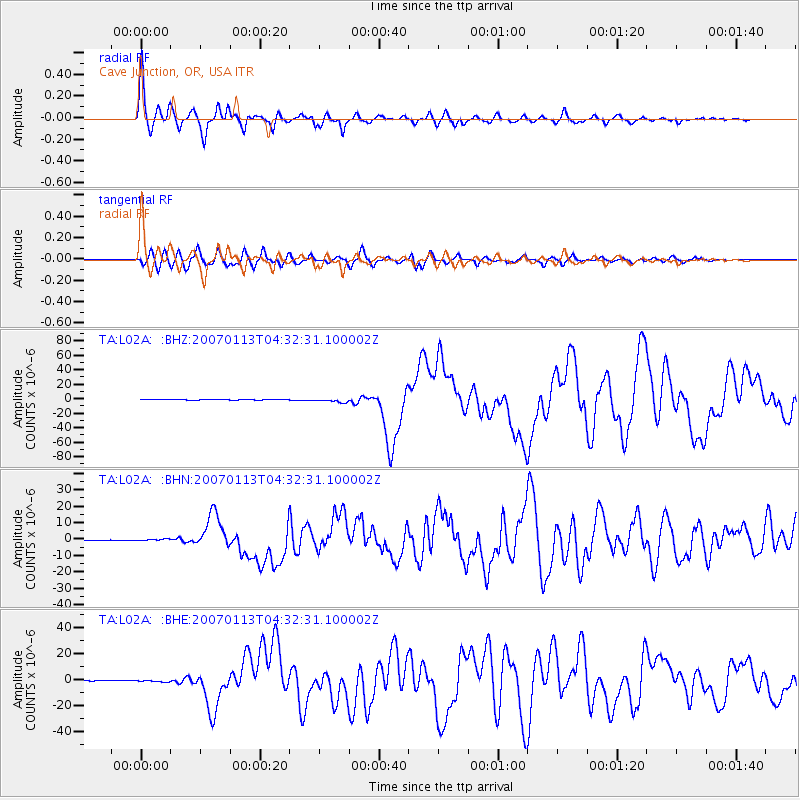
Signal To Noise
| Channel | StoN | STA | LTA |
| TA:L02A: :BHN:20070113T04:32:31.100002Z | 2.9805446 | 6.0930796E-7 | 2.044284E-7 |
| TA:L02A: :BHE:20070113T04:32:31.100002Z | 4.3743134 | 9.708746E-7 | 2.2194902E-7 |
| TA:L02A: :BHZ:20070113T04:32:31.100002Z | 8.13912 | 2.4603828E-6 | 3.02291E-7 |
| Arrivals |
| Ps | 2.8 SECOND |
| PpPs | 7.8 SECOND |
| PsPs/PpSs | 11 SECOND |


