You are here: Home > Network List > TA - USArray Transportable Network (new EarthScope stations) Stations List
> Station L02A Cave Junction, OR, USA > Earthquake Result Viewer
L02A Cave Junction, OR, USA - Earthquake Result Viewer
| Earthquake location: |
East Of Kuril Islands |
| Earthquake latitude/longitude: |
44.1/154.7 |
| Earthquake time(UTC): |
2006/11/15 (319) 11:48:04 GMT |
| Earthquake Depth: |
10 km |
| Earthquake Magnitude: |
5.5 MB |
| Earthquake Catalog/Contributor: |
WHDF/NEIC |
|
| Network: |
TA USArray Transportable Network (new EarthScope stations) |
| Station: |
L02A Cave Junction, OR, USA |
| Lat/Lon: |
42.16 N/123.60 W |
| Elevation: |
485 m |
|
| Distance: |
57.2 deg |
| Az: |
61.035 deg |
| Baz: |
302.04 deg |
| Ray Param: |
0.06361589 |
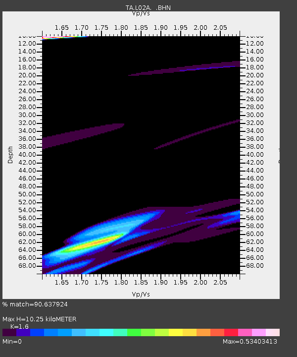
| Estimated Moho Depth: |
10.25 km |
| Estimated Crust Vp/Vs: |
1.60 |
| Assumed Crust Vp: |
6.522 km/s |
| Estimated Crust Vs: |
4.076 km/s |
| Estimated Crust Poisson's Ratio: |
0.18 |
|
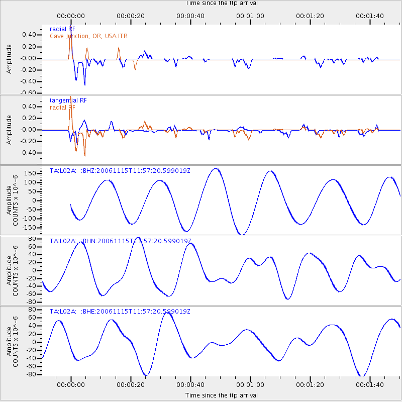
| Radial Match: |
90.637924 % |
| Radial Bump: |
400 |
| Transverse Match: |
86.18279 % |
| Transverse Bump: |
400 |
| SOD ConfigId: |
2564 |
| Insert Time: |
2010-03-07 04:04:08.215 +0000 |
| GWidth: |
2.5 |
| Max Bumps: |
400 |
| Tol: |
0.001 |
|
Signal To Noise
| Channel | StoN | STA | LTA |
| TA:L02A: :BHN:20061115T11:57:20.599019Z | 2.442478 | 6.395469E-5 | 2.6184347E-5 |
| TA:L02A: :BHE:20061115T11:57:20.599019Z | 0.58285105 | 3.007055E-5 | 5.159217E-5 |
| TA:L02A: :BHZ:20061115T11:57:20.599019Z | 1.2307556 | 1.0022138E-4 | 8.143078E-5 |
| Arrivals |
| Ps | 1.0 SECOND |
| PpPs | 3.9 SECOND |
| PsPs/PpSs | 4.9 SECOND |


