You are here: Home > Network List > TA - USArray Transportable Network (new EarthScope stations) Stations List
> Station L02A Cave Junction, OR, USA > Earthquake Result Viewer
L02A Cave Junction, OR, USA - Earthquake Result Viewer
| Earthquake location: |
Solomon Islands |
| Earthquake latitude/longitude: |
-6.8/155.5 |
| Earthquake time(UTC): |
2006/09/01 (244) 10:18:51 GMT |
| Earthquake Depth: |
38 km |
| Earthquake Magnitude: |
6.3 MB, 6.7 MS, 6.8 MW, 6.7 MW |
| Earthquake Catalog/Contributor: |
WHDF/NEIC |
|
| Network: |
TA USArray Transportable Network (new EarthScope stations) |
| Station: |
L02A Cave Junction, OR, USA |
| Lat/Lon: |
42.16 N/123.60 W |
| Elevation: |
485 m |
|
| Distance: |
87.8 deg |
| Az: |
47.284 deg |
| Baz: |
258.915 deg |
| Ray Param: |
0.043023746 |
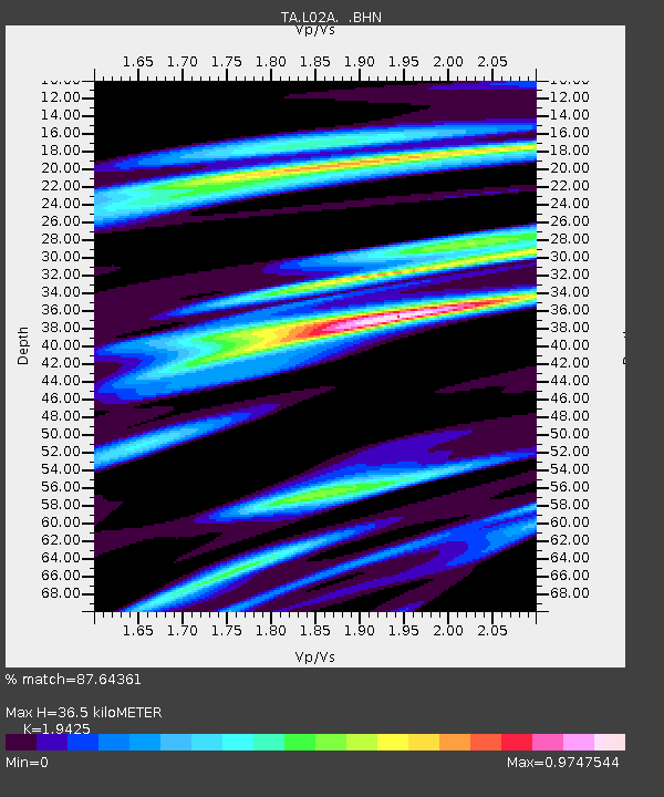
| Estimated Moho Depth: |
36.5 km |
| Estimated Crust Vp/Vs: |
1.94 |
| Assumed Crust Vp: |
6.522 km/s |
| Estimated Crust Vs: |
3.357 km/s |
| Estimated Crust Poisson's Ratio: |
0.32 |
|
| Radial Match: |
87.64361 % |
| Radial Bump: |
400 |
| Transverse Match: |
59.03599 % |
| Transverse Bump: |
400 |
| SOD ConfigId: |
2665 |
| Insert Time: |
2010-03-07 04:04:19.308 +0000 |
| GWidth: |
2.5 |
| Max Bumps: |
400 |
| Tol: |
0.001 |
|
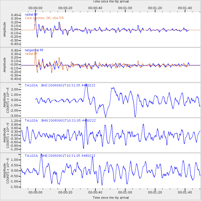
Signal To Noise
| Channel | StoN | STA | LTA |
| TA:L02A: :BHN:20060901T10:31:05.448022Z | 0.6119372 | 1.6497235E-7 | 2.6959034E-7 |
| TA:L02A: :BHE:20060901T10:31:05.448022Z | 3.7016544 | 7.097382E-7 | 1.917354E-7 |
| TA:L02A: :BHZ:20060901T10:31:05.448022Z | 6.6341295 | 1.6111416E-6 | 2.4285652E-7 |
| Arrivals |
| Ps | 5.4 SECOND |
| PpPs | 16 SECOND |
| PsPs/PpSs | 22 SECOND |


