You are here: Home > Network List > TA - USArray Transportable Network (new EarthScope stations) Stations List
> Station L02A Cave Junction, OR, USA > Earthquake Result Viewer
L02A Cave Junction, OR, USA - Earthquake Result Viewer
| Earthquake location: |
Vanuatu Islands |
| Earthquake latitude/longitude: |
-15.8/167.8 |
| Earthquake time(UTC): |
2006/08/07 (219) 22:18:54 GMT |
| Earthquake Depth: |
141 km |
| Earthquake Magnitude: |
6.0 MB, 6.8 MW, 6.8 MW |
| Earthquake Catalog/Contributor: |
WHDF/NEIC |
|
| Network: |
TA USArray Transportable Network (new EarthScope stations) |
| Station: |
L02A Cave Junction, OR, USA |
| Lat/Lon: |
42.16 N/123.60 W |
| Elevation: |
485 m |
|
| Distance: |
85.4 deg |
| Az: |
43.991 deg |
| Baz: |
244.071 deg |
| Ray Param: |
0.044489883 |
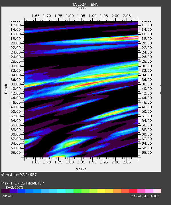
| Estimated Moho Depth: |
17.25 km |
| Estimated Crust Vp/Vs: |
2.10 |
| Assumed Crust Vp: |
6.522 km/s |
| Estimated Crust Vs: |
3.109 km/s |
| Estimated Crust Poisson's Ratio: |
0.35 |
|
| Radial Match: |
93.94957 % |
| Radial Bump: |
400 |
| Transverse Match: |
73.398056 % |
| Transverse Bump: |
400 |
| SOD ConfigId: |
2665 |
| Insert Time: |
2010-03-07 04:04:23.036 +0000 |
| GWidth: |
2.5 |
| Max Bumps: |
400 |
| Tol: |
0.001 |
|
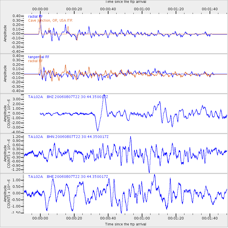
Signal To Noise
| Channel | StoN | STA | LTA |
| TA:L02A: :BHN:20060807T22:30:44.350017Z | 2.081778 | 2.925522E-7 | 1.4052996E-7 |
| TA:L02A: :BHE:20060807T22:30:44.350017Z | 4.279176 | 5.417508E-7 | 1.2660165E-7 |
| TA:L02A: :BHZ:20060807T22:30:44.350017Z | 11.533542 | 1.7604593E-6 | 1.5263824E-7 |
| Arrivals |
| Ps | 3.0 SECOND |
| PpPs | 8.0 SECOND |
| PsPs/PpSs | 11 SECOND |


