L02A Cave Junction, OR, USA - Earthquake Result Viewer
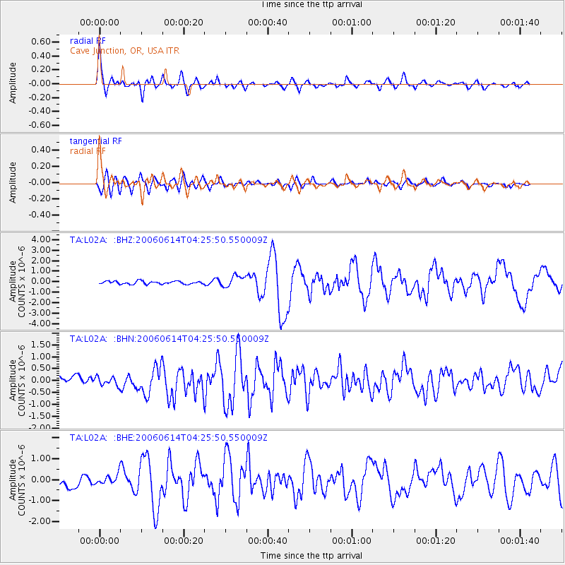
Earthquake location: Rat Islands, Aleutian Islands
Earthquake latitude/longitude: 51.8/177.1
Earthquake time(UTC): 2006/06/14 (165) 04:18:42 GMT
Earthquake Depth: 14 km
Earthquake Magnitude: 5.9 MB, 6.4 MS, 6.4 MW, 6.4 MW
Earthquake Catalog/Contributor: WHDF/NEIC
Network: TA USArray Transportable Network (new EarthScope stations)
Station: L02A Cave Junction, OR, USA
Lat/Lon: 42.16 N/123.60 W
Elevation: 485 m
Distance: 40.6 deg
Az: 79.506 deg
Baz: 304.711 deg
Ray Param: 0.074316256
Estimated Moho Depth: 17.5 km
Estimated Crust Vp/Vs: 1.98
Assumed Crust Vp: 6.522 km/s
Estimated Crust Vs: 3.302 km/s
Estimated Crust Poisson's Ratio: 0.33
Radial Match: 86.498695 %
Radial Bump: 400
Transverse Match: 61.816128 %
Transverse Bump: 400
SOD ConfigId: 5745
Insert Time: 2010-03-07 04:04:26.490 +0000
GWidth: 2.5
Max Bumps: 400
Tol: 0.001

Signal To Noise

ChannelStoNSTALTA
TA:L02A: :BHN:20060614T04:25:50.550009Z1.03220431.9540833E-71.8931169E-7
TA:L02A: :BHE:20060614T04:25:50.550009Z1.0748772.6536406E-72.4687853E-7
TA:L02A: :BHZ:20060614T04:25:50.550009Z3.92603235.454528E-71.3893232E-7
Arrivals
Ps2.8 SECOND
PpPs7.5 SECOND
PsPs/PpSs10 SECOND