You are here: Home > Network List > TA - USArray Transportable Network (new EarthScope stations) Stations List
> Station L02A Cave Junction, OR, USA > Earthquake Result Viewer
L02A Cave Junction, OR, USA - Earthquake Result Viewer
| Earthquake location: |
Eastern Siberia, Russia |
| Earthquake latitude/longitude: |
60.9/167.1 |
| Earthquake time(UTC): |
2006/04/20 (110) 23:25:02 GMT |
| Earthquake Depth: |
22 km |
| Earthquake Magnitude: |
6.8 MB, 7.6 MS, 7.6 MW, 7.3 MW |
| Earthquake Catalog/Contributor: |
WHDF/NEIC |
|
| Network: |
TA USArray Transportable Network (new EarthScope stations) |
| Station: |
L02A Cave Junction, OR, USA |
| Lat/Lon: |
42.16 N/123.60 W |
| Elevation: |
485 m |
|
| Distance: |
44.6 deg |
| Az: |
82.056 deg |
| Baz: |
319.45 deg |
| Ray Param: |
0.07177625 |
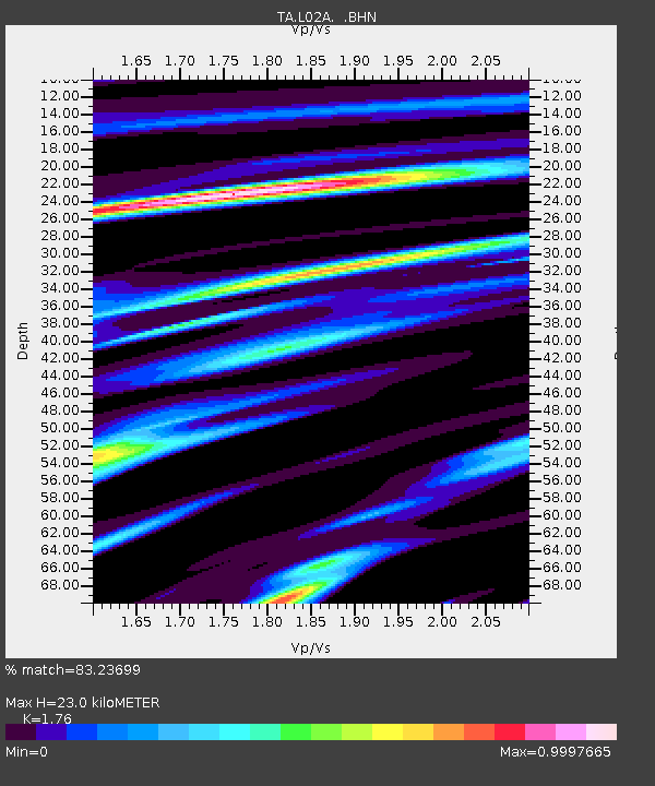
| Estimated Moho Depth: |
23.0 km |
| Estimated Crust Vp/Vs: |
1.76 |
| Assumed Crust Vp: |
6.522 km/s |
| Estimated Crust Vs: |
3.705 km/s |
| Estimated Crust Poisson's Ratio: |
0.26 |
|
| Radial Match: |
83.23699 % |
| Radial Bump: |
400 |
| Transverse Match: |
81.32468 % |
| Transverse Bump: |
400 |
| SOD ConfigId: |
2669 |
| Insert Time: |
2010-03-07 04:04:30.934 +0000 |
| GWidth: |
2.5 |
| Max Bumps: |
400 |
| Tol: |
0.001 |
|
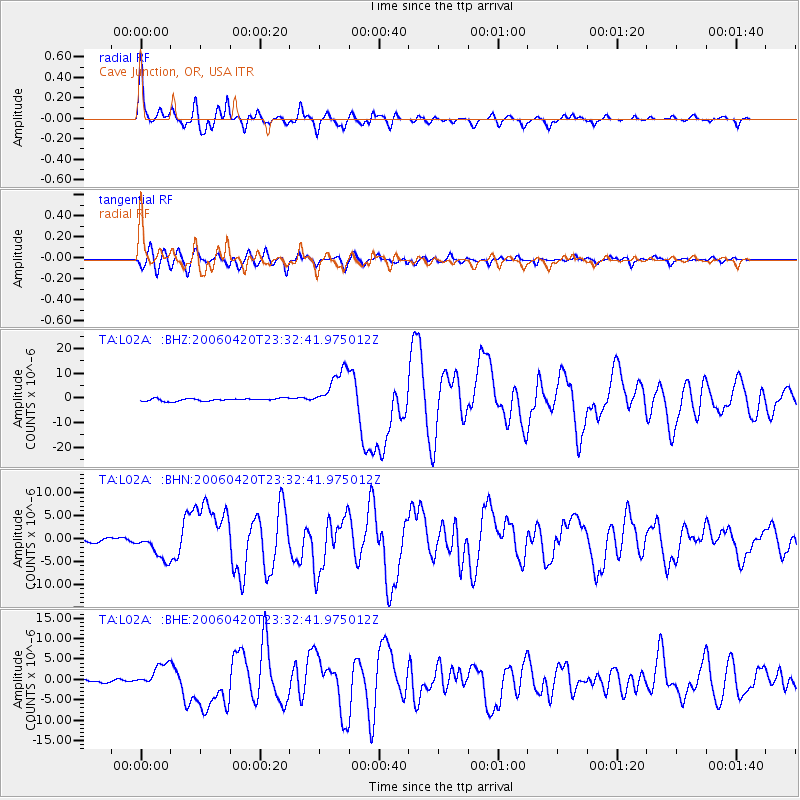
Signal To Noise
| Channel | StoN | STA | LTA |
| TA:L02A: :BHN:20060420T23:32:41.975012Z | 3.1148326 | 2.757513E-6 | 8.852844E-7 |
| TA:L02A: :BHE:20060420T23:32:41.975012Z | 4.137938 | 2.6000605E-6 | 6.283469E-7 |
| TA:L02A: :BHZ:20060420T23:32:41.975012Z | 16.21517 | 8.150052E-6 | 5.0261895E-7 |
| Arrivals |
| Ps | 2.9 SECOND |
| PpPs | 9.1 SECOND |
| PsPs/PpSs | 12 SECOND |


