You are here: Home > Network List > TA - USArray Transportable Network (new EarthScope stations) Stations List
> Station P10A Eureka, NV, USA > Earthquake Result Viewer
P10A Eureka, NV, USA - Earthquake Result Viewer
| Earthquake location: |
Northern Chile |
| Earthquake latitude/longitude: |
-22.2/-69.9 |
| Earthquake time(UTC): |
2007/11/14 (318) 15:40:50 GMT |
| Earthquake Depth: |
40 km |
| Earthquake Magnitude: |
6.7 MB, 7.4 MS, 7.7 MW, 7.4 ME |
| Earthquake Catalog/Contributor: |
WHDF/NEIC |
|
| Network: |
TA USArray Transportable Network (new EarthScope stations) |
| Station: |
P10A Eureka, NV, USA |
| Lat/Lon: |
39.62 N/116.46 W |
| Elevation: |
1874 m |
|
| Distance: |
75.4 deg |
| Az: |
324.564 deg |
| Baz: |
135.938 deg |
| Ray Param: |
0.051658522 |
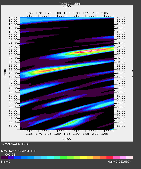
| Estimated Moho Depth: |
27.75 km |
| Estimated Crust Vp/Vs: |
1.98 |
| Assumed Crust Vp: |
6.276 km/s |
| Estimated Crust Vs: |
3.17 km/s |
| Estimated Crust Poisson's Ratio: |
0.33 |
|
| Radial Match: |
86.05646 % |
| Radial Bump: |
400 |
| Transverse Match: |
86.04925 % |
| Transverse Bump: |
400 |
| SOD ConfigId: |
2564 |
| Insert Time: |
2010-03-07 04:04:35.717 +0000 |
| GWidth: |
2.5 |
| Max Bumps: |
400 |
| Tol: |
0.001 |
|
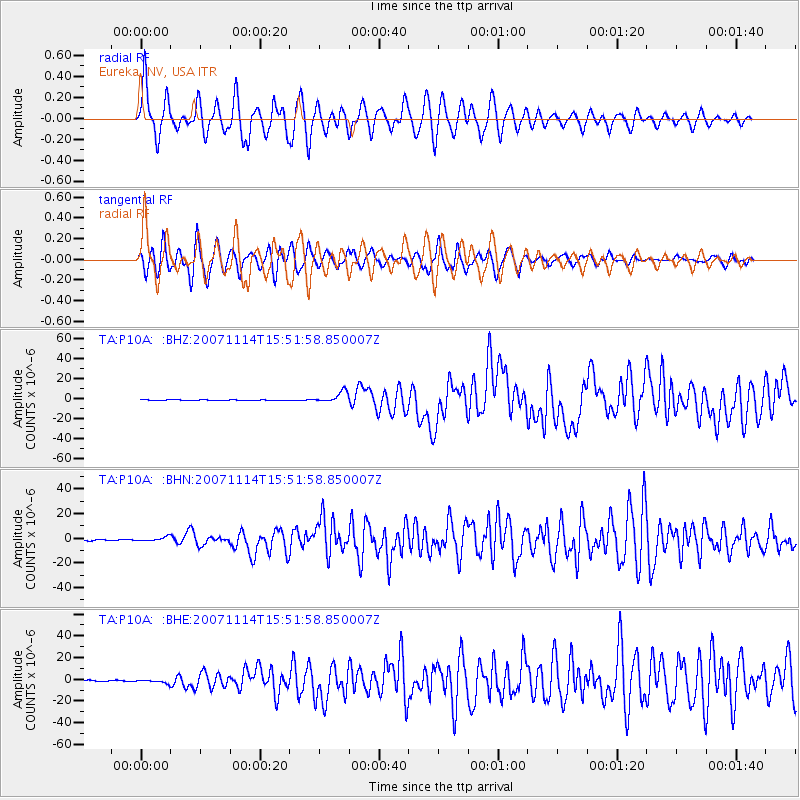
Signal To Noise
| Channel | StoN | STA | LTA |
| TA:P10A: :BHN:20071114T15:51:58.850007Z | 4.008157 | 1.6498358E-6 | 4.1161957E-7 |
| TA:P10A: :BHE:20071114T15:51:58.850007Z | 2.4708714 | 1.5066187E-6 | 6.097519E-7 |
| TA:P10A: :BHZ:20071114T15:51:58.850007Z | 21.722729 | 5.5252176E-6 | 2.5435193E-7 |
| Arrivals |
| Ps | 4.5 SECOND |
| PpPs | 13 SECOND |
| PsPs/PpSs | 17 SECOND |


