
Station TA P10A - Eureka, NV, USA
Network: TA - USArray Transportable Network (new EarthScope stations)
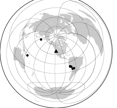
Nearby stations (2 deg radius)
| Station | Name | (Lat, Lon) | Start / End | Elevation |
| P10A | Eureka, NV, USA | (39.62, -116.46) | 2006-06-07 / 2499-01-01 | 1.9 km |
| Crust2 Type: | M5,extended crust, 0.5 km seds. |
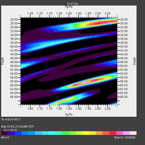
| Thickness Estimate: | 58 km |
| Thickness StdDev: | 12 km |
| Vp/Vs Estimate: | 1.94 |
| Vp/Vs StdDev: | 0.05 |
| Vs Estimate: | 3.231 km/s |
| Poisson's Ratio: | 0.32 |
| Peak Value: | 0.15 |
| Assumed Vp: | 6.276 km/s |
| Ps Weight: | 0.33333334 |
| PpPs Weight: | 0.33333334 |
| PsPs Weight: | 0.33333328 |
| Residual Complexity: | 0.806 |
| Nearby stations H: | +- |
| (2.0 deg) Vp/Vs: | +- |
1 with match > 90% ( 10.0 %) and 10 with match > 80% ( 100.0 %) out of 10.
Download stack as xyz text file.
Azimuth Distribution of Events:
Prior Results for this Station
| Study | Thickness | Vp/Vs | Vp | Vs | Poissons Ratio | Extra |
| EARS | 58 km | 1.94 | 6.276 km/s | 3.231 km/s | 0.32 | |
| Crust2.0 | 31 km | 1.78 | 6.276 km/s | 3.529 km/s | 0.27 | M5,extended crust, 0.5 km seds. |
| Global Maxima | 58 km | 1.94 | 6.276 km/s | 3.231 km/s | 0.32 | amp=0.1488888 |
| Local Maxima 1 | 27 km | 2.08 | 6.276 km/s | 3.021 km/s | 0.35 | amp=0.1310689 |
| Local Maxima 2 | 70 km | 2.10 | 6.276 km/s | 2.992 km/s | 0.35 | amp=0.086034246 |
| Local Maxima 3 | 67 km | 1.86 | 6.276 km/s | 3.383 km/s | 0.30 | amp=0.08221087 |
| Local Maxima 4 | 27 km | 1.99 | 6.276 km/s | 3.15 km/s | 0.33 | amp=0.071558625 |
| Predicted Arrivals for vertical incidence (zero ray parameter) | |
| Ps | 8.75 SECOND |
| PpPs | 27.31 SECOND |
| PsPs/PpSs | 36.06 SECOND |
Events Processed for this Station
Download zip of receiver functions as SAC
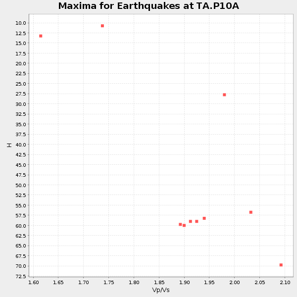
Plot maxima for each earthquake.
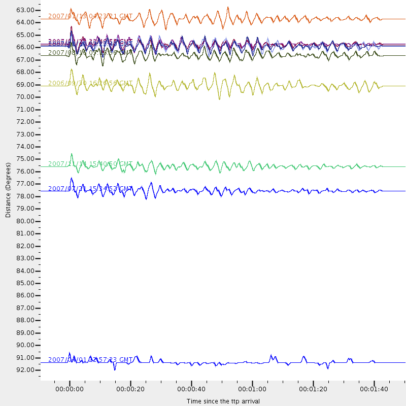
Events Used in the Stack
(10 events)| Radial Match | Distance | Baz | FERegion | Time | Lat/Lon | Depth | Magnitude |
| 93.62244 | 64.5 deg | 136.276 deg | Near Coast Of Peru | 2007/08/15 23:40:57 GMT | (-13.4, -76.6) | 39 km | 6.7 MB, 7.9 MS, 8.0 MW, 7.5 ME |
| 89.52439 | 64.7 deg | 136.405 deg | Near Coast Of Peru | 2007/08/17 13:18:13 GMT | (-13.6, -76.6) | 48 km | 5.6 MB, 5.6 MS, 5.9 MW |
| 88.53466 | 68.2 deg | 134.595 deg | Southern Peru | 2006/09/30 16:26:56 GMT | (-15.6, -73.2) | 107 km | 5.6 MB, 6.0 MW, 5.9 MW |
| 87.542244 | 65.5 deg | 136.389 deg | Near Coast Of Peru | 2007/08/16 05:16:56 GMT | (-14.3, -76.1) | 23 km | 5.8 MB, 6.1 MS, 6.3 MW, 6.2 ML |
| 87.23108 | 77.6 deg | 132.732 deg | Jujuy Province, Argentina | 2007/07/21 15:34:52 GMT | (-22.2, -65.8) | 290 km | 5.8 MB, 6.4 MW, 6.3 MW |
| 86.05646 | 75.4 deg | 135.938 deg | Northern Chile | 2007/11/14 15:40:50 GMT | (-22.2, -69.9) | 40 km | 6.7 MB, 7.4 MS, 7.7 MW, 7.4 ME |
| 84.86477 | 62.2 deg | 308.323 deg | East Of Kuril Islands | 2007/01/13 04:23:21 GMT | (46.2, 154.5) | 10 km | 7.3 MB, 8.2 MS, 8.1 MW, 7.9 MW |
| 84.41634 | 64.5 deg | 136.385 deg | Near Coast Of Peru | 2006/10/20 10:48:56 GMT | (-13.5, -76.7) | 23 km | 5.9 MB, 6.6 MS, 6.7 MW, 6.6 MW |
| 83.88464 | 64.7 deg | 136.433 deg | Near Coast Of Peru | 2007/08/19 01:22:40 GMT | (-13.6, -76.6) | 26 km | 5.9 MB, 5.4 MS, 5.8 MW, 5.5 ML |
| 80.74273 | 92.8 deg | 262.623 deg | Solomon Islands | 2007/04/01 22:57:23 GMT | (-7.5, 156.1) | 18 km | 5.7 MB |
Losers
(0 events)| Radial Match | Distance | Baz | FERegion | Time | Lat/Lon | Depth | Magnitude | Reason |
