You are here: Home > Network List > TA - USArray Transportable Network (new EarthScope stations) Stations List
> Station P10A Eureka, NV, USA > Earthquake Result Viewer
P10A Eureka, NV, USA - Earthquake Result Viewer
| Earthquake location: |
Near Coast Of Peru |
| Earthquake latitude/longitude: |
-13.6/-76.6 |
| Earthquake time(UTC): |
2007/08/19 (231) 01:22:40 GMT |
| Earthquake Depth: |
26 km |
| Earthquake Magnitude: |
5.9 MB, 5.4 MS, 5.8 MW, 5.5 ML |
| Earthquake Catalog/Contributor: |
WHDF/NEIC |
|
| Network: |
TA USArray Transportable Network (new EarthScope stations) |
| Station: |
P10A Eureka, NV, USA |
| Lat/Lon: |
39.62 N/116.46 W |
| Elevation: |
1874 m |
|
| Distance: |
64.7 deg |
| Az: |
326.801 deg |
| Baz: |
136.433 deg |
| Ray Param: |
0.058737084 |
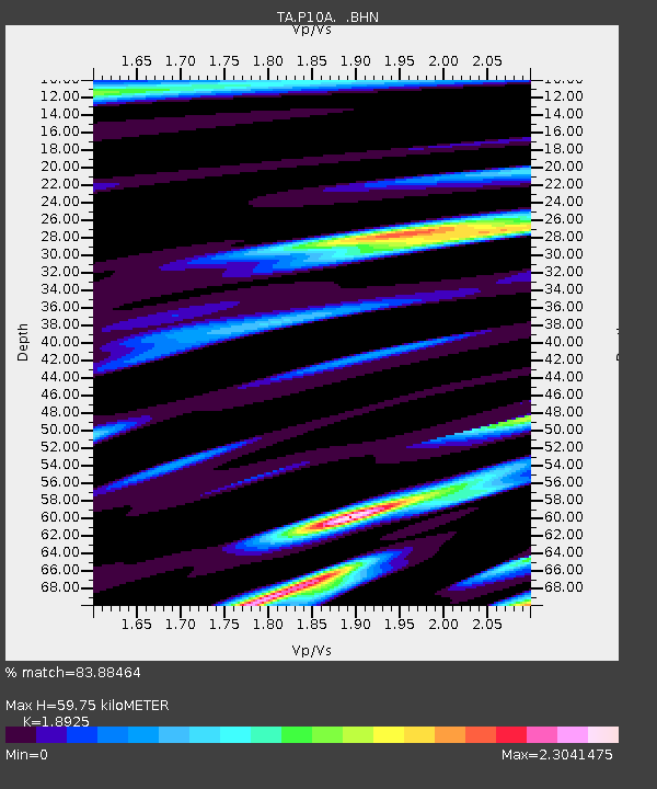
| Estimated Moho Depth: |
59.75 km |
| Estimated Crust Vp/Vs: |
1.89 |
| Assumed Crust Vp: |
6.276 km/s |
| Estimated Crust Vs: |
3.316 km/s |
| Estimated Crust Poisson's Ratio: |
0.31 |
|
| Radial Match: |
83.88464 % |
| Radial Bump: |
369 |
| Transverse Match: |
73.55948 % |
| Transverse Bump: |
356 |
| SOD ConfigId: |
2564 |
| Insert Time: |
2010-03-07 04:04:38.119 +0000 |
| GWidth: |
2.5 |
| Max Bumps: |
400 |
| Tol: |
0.001 |
|
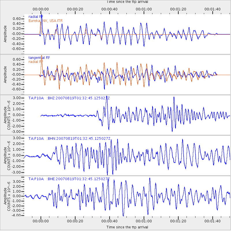
Signal To Noise
| Channel | StoN | STA | LTA |
| TA:P10A: :BHN:20070819T01:32:45.125027Z | 0.9455224 | 1.9894776E-7 | 2.104104E-7 |
| TA:P10A: :BHE:20070819T01:32:45.125027Z | 1.9762787 | 2.994392E-7 | 1.5151669E-7 |
| TA:P10A: :BHZ:20070819T01:32:45.125027Z | 4.7275143 | 3.9966616E-7 | 8.454045E-8 |
| Arrivals |
| Ps | 8.8 SECOND |
| PpPs | 27 SECOND |
| PsPs/PpSs | 35 SECOND |


