You are here: Home > Network List > TA - USArray Transportable Network (new EarthScope stations) Stations List
> Station P10A Eureka, NV, USA > Earthquake Result Viewer
P10A Eureka, NV, USA - Earthquake Result Viewer
| Earthquake location: |
Near Coast Of Peru |
| Earthquake latitude/longitude: |
-14.3/-76.1 |
| Earthquake time(UTC): |
2007/08/16 (228) 05:16:56 GMT |
| Earthquake Depth: |
23 km |
| Earthquake Magnitude: |
5.8 MB, 6.1 MS, 6.3 MW, 6.2 ML |
| Earthquake Catalog/Contributor: |
WHDF/NEIC |
|
| Network: |
TA USArray Transportable Network (new EarthScope stations) |
| Station: |
P10A Eureka, NV, USA |
| Lat/Lon: |
39.62 N/116.46 W |
| Elevation: |
1874 m |
|
| Distance: |
65.5 deg |
| Az: |
326.665 deg |
| Baz: |
136.389 deg |
| Ray Param: |
0.05821782 |
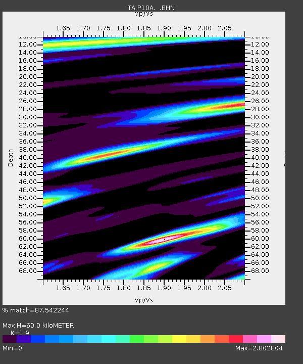
| Estimated Moho Depth: |
60.0 km |
| Estimated Crust Vp/Vs: |
1.90 |
| Assumed Crust Vp: |
6.276 km/s |
| Estimated Crust Vs: |
3.303 km/s |
| Estimated Crust Poisson's Ratio: |
0.31 |
|
| Radial Match: |
87.542244 % |
| Radial Bump: |
400 |
| Transverse Match: |
77.80037 % |
| Transverse Bump: |
400 |
| SOD ConfigId: |
2564 |
| Insert Time: |
2010-03-07 04:04:42.183 +0000 |
| GWidth: |
2.5 |
| Max Bumps: |
400 |
| Tol: |
0.001 |
|
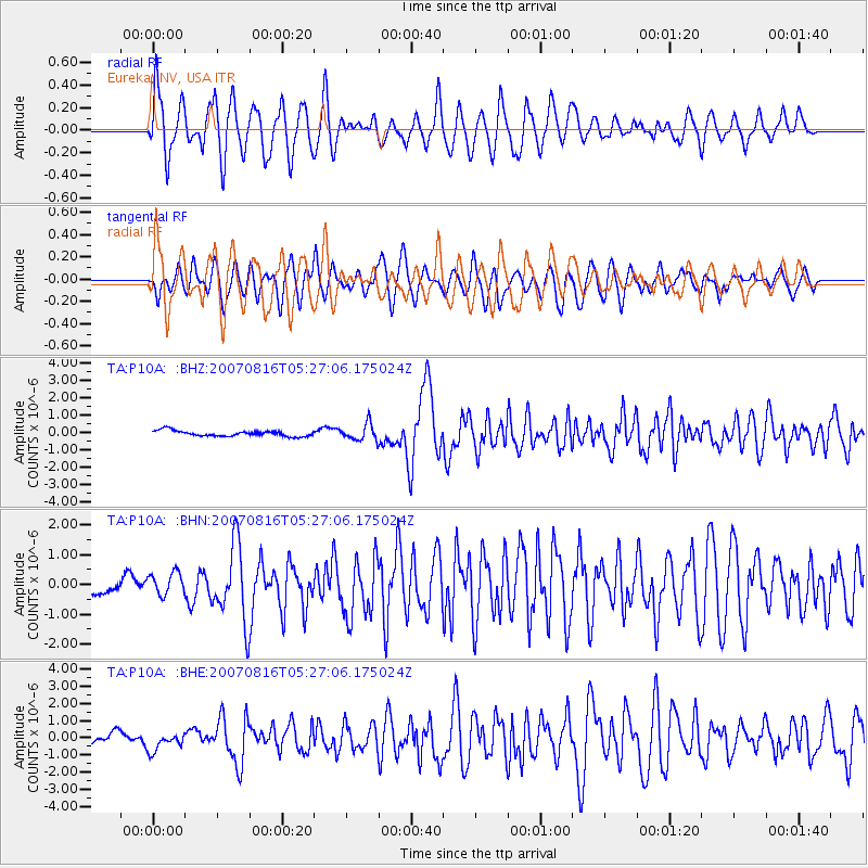
Signal To Noise
| Channel | StoN | STA | LTA |
| TA:P10A: :BHN:20070816T05:27:06.175024Z | 1.396223 | 3.75435E-7 | 2.6889333E-7 |
| TA:P10A: :BHE:20070816T05:27:06.175024Z | 1.7770182 | 5.349208E-7 | 3.0102154E-7 |
| TA:P10A: :BHZ:20070816T05:27:06.175024Z | 2.8948917 | 4.7334993E-7 | 1.6351214E-7 |
| Arrivals |
| Ps | 8.9 SECOND |
| PpPs | 27 SECOND |
| PsPs/PpSs | 36 SECOND |


