You are here: Home > Network List > TA - USArray Transportable Network (new EarthScope stations) Stations List
> Station P10A Eureka, NV, USA > Earthquake Result Viewer
P10A Eureka, NV, USA - Earthquake Result Viewer
| Earthquake location: |
Solomon Islands |
| Earthquake latitude/longitude: |
-7.5/156.1 |
| Earthquake time(UTC): |
2007/04/01 (091) 22:57:23 GMT |
| Earthquake Depth: |
18 km |
| Earthquake Magnitude: |
5.7 MB |
| Earthquake Catalog/Contributor: |
WHDF/NEIC |
|
| Network: |
TA USArray Transportable Network (new EarthScope stations) |
| Station: |
P10A Eureka, NV, USA |
| Lat/Lon: |
39.62 N/116.46 W |
| Elevation: |
1874 m |
|
| Distance: |
92.8 deg |
| Az: |
50.585 deg |
| Baz: |
262.623 deg |
| Ray Param: |
0.041381054 |
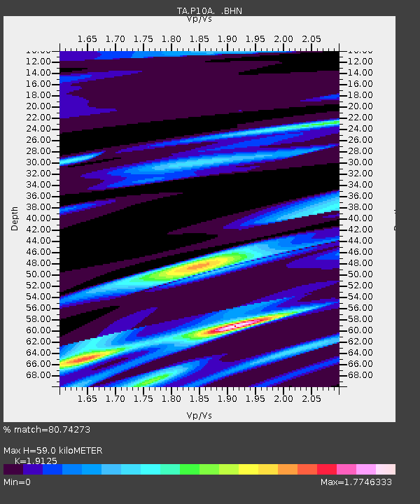
| Estimated Moho Depth: |
59.0 km |
| Estimated Crust Vp/Vs: |
1.91 |
| Assumed Crust Vp: |
6.276 km/s |
| Estimated Crust Vs: |
3.281 km/s |
| Estimated Crust Poisson's Ratio: |
0.31 |
|
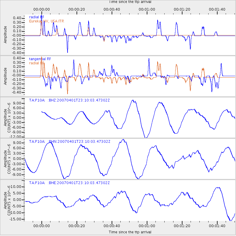
| Radial Match: |
80.74273 % |
| Radial Bump: |
400 |
| Transverse Match: |
57.834927 % |
| Transverse Bump: |
400 |
| SOD ConfigId: |
2564 |
| Insert Time: |
2010-03-07 04:04:47.366 +0000 |
| GWidth: |
2.5 |
| Max Bumps: |
400 |
| Tol: |
0.001 |
|
Signal To Noise
| Channel | StoN | STA | LTA |
| TA:P10A: :BHN:20070401T23:10:03.47302Z | 2.210355 | 6.759759E-6 | 3.058223E-6 |
| TA:P10A: :BHE:20070401T23:10:03.47302Z | 0.71558225 | 2.6257376E-6 | 3.669372E-6 |
| TA:P10A: :BHZ:20070401T23:10:03.47302Z | 1.1892236 | 2.8249715E-6 | 2.3754753E-6 |
| Arrivals |
| Ps | 8.7 SECOND |
| PpPs | 27 SECOND |
| PsPs/PpSs | 36 SECOND |


