You are here: Home > Network List > TA - USArray Transportable Network (new EarthScope stations) Stations List
> Station P10A Eureka, NV, USA > Earthquake Result Viewer
P10A Eureka, NV, USA - Earthquake Result Viewer
| Earthquake location: |
East Of Kuril Islands |
| Earthquake latitude/longitude: |
46.2/154.5 |
| Earthquake time(UTC): |
2007/01/13 (013) 04:23:21 GMT |
| Earthquake Depth: |
10 km |
| Earthquake Magnitude: |
7.3 MB, 8.2 MS, 8.1 MW, 7.9 MW |
| Earthquake Catalog/Contributor: |
WHDF/NEIC |
|
| Network: |
TA USArray Transportable Network (new EarthScope stations) |
| Station: |
P10A Eureka, NV, USA |
| Lat/Lon: |
39.62 N/116.46 W |
| Elevation: |
1874 m |
|
| Distance: |
62.2 deg |
| Az: |
60.822 deg |
| Baz: |
308.323 deg |
| Ray Param: |
0.060389668 |
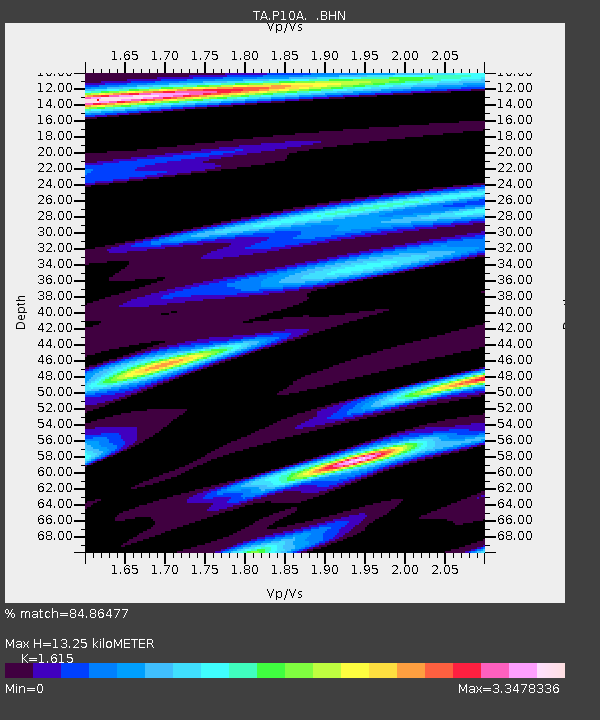
| Estimated Moho Depth: |
13.25 km |
| Estimated Crust Vp/Vs: |
1.62 |
| Assumed Crust Vp: |
6.276 km/s |
| Estimated Crust Vs: |
3.886 km/s |
| Estimated Crust Poisson's Ratio: |
0.19 |
|
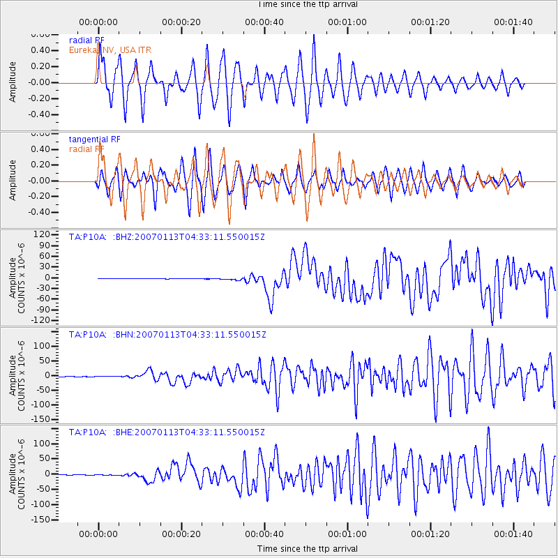
| Radial Match: |
84.86477 % |
| Radial Bump: |
400 |
| Transverse Match: |
81.17317 % |
| Transverse Bump: |
400 |
| SOD ConfigId: |
2564 |
| Insert Time: |
2010-03-07 04:04:48.965 +0000 |
| GWidth: |
2.5 |
| Max Bumps: |
400 |
| Tol: |
0.001 |
|
Signal To Noise
| Channel | StoN | STA | LTA |
| TA:P10A: :BHN:20070113T04:33:11.550015Z | 1.415564 | 5.5314746E-7 | 3.9076116E-7 |
| TA:P10A: :BHE:20070113T04:33:11.550015Z | 3.2144423 | 8.492838E-7 | 2.6420875E-7 |
| TA:P10A: :BHZ:20070113T04:33:11.550015Z | 9.754531 | 2.555094E-6 | 2.619392E-7 |
| Arrivals |
| Ps | 1.4 SECOND |
| PpPs | 5.3 SECOND |
| PsPs/PpSs | 6.6 SECOND |


