You are here: Home > Network List > TA - USArray Transportable Network (new EarthScope stations) Stations List
> Station P10A Eureka, NV, USA > Earthquake Result Viewer
P10A Eureka, NV, USA - Earthquake Result Viewer
| Earthquake location: |
Southern Peru |
| Earthquake latitude/longitude: |
-15.6/-73.2 |
| Earthquake time(UTC): |
2006/09/30 (273) 16:26:56 GMT |
| Earthquake Depth: |
107 km |
| Earthquake Magnitude: |
5.6 MB, 6.0 MW, 5.9 MW |
| Earthquake Catalog/Contributor: |
WHDF/NEIC |
|
| Network: |
TA USArray Transportable Network (new EarthScope stations) |
| Station: |
P10A Eureka, NV, USA |
| Lat/Lon: |
39.62 N/116.46 W |
| Elevation: |
1874 m |
|
| Distance: |
68.2 deg |
| Az: |
325.198 deg |
| Baz: |
134.595 deg |
| Ray Param: |
0.05621259 |
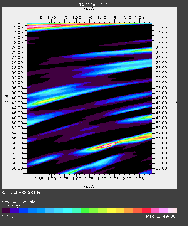
| Estimated Moho Depth: |
58.25 km |
| Estimated Crust Vp/Vs: |
1.94 |
| Assumed Crust Vp: |
6.276 km/s |
| Estimated Crust Vs: |
3.235 km/s |
| Estimated Crust Poisson's Ratio: |
0.32 |
|
| Radial Match: |
88.53466 % |
| Radial Bump: |
400 |
| Transverse Match: |
81.49536 % |
| Transverse Bump: |
400 |
| SOD ConfigId: |
2564 |
| Insert Time: |
2010-03-07 04:04:50.950 +0000 |
| GWidth: |
2.5 |
| Max Bumps: |
400 |
| Tol: |
0.001 |
|
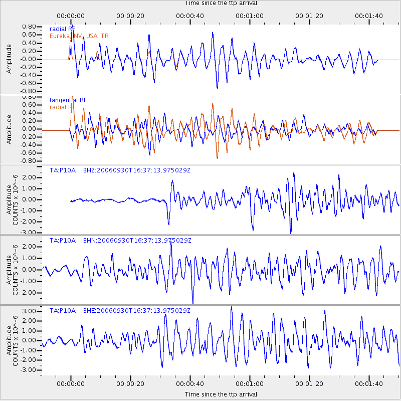
Signal To Noise
| Channel | StoN | STA | LTA |
| TA:P10A: :BHN:20060930T16:37:13.975029Z | 2.0371392 | 4.9164E-7 | 2.4133843E-7 |
| TA:P10A: :BHE:20060930T16:37:13.975029Z | 2.0206869 | 6.156171E-7 | 3.0465733E-7 |
| TA:P10A: :BHZ:20060930T16:37:13.975029Z | 8.871543 | 9.444389E-7 | 1.06457115E-7 |
| Arrivals |
| Ps | 9.0 SECOND |
| PpPs | 26 SECOND |
| PsPs/PpSs | 35 SECOND |


