You are here: Home > Network List > TA - USArray Transportable Network (new EarthScope stations) Stations List
> Station A08A Turner Farm, Oroville, WA, USA > Earthquake Result Viewer
A08A Turner Farm, Oroville, WA, USA - Earthquake Result Viewer
| Earthquake location: |
Svalbard Region |
| Earthquake latitude/longitude: |
77.1/18.6 |
| Earthquake time(UTC): |
2008/02/21 (052) 02:46:17 GMT |
| Earthquake Depth: |
10 km |
| Earthquake Magnitude: |
5.7 MB, 5.9 MS, 6.1 MW, 6.0 MW |
| Earthquake Catalog/Contributor: |
WHDF/NEIC |
|
| Network: |
TA USArray Transportable Network (new EarthScope stations) |
| Station: |
A08A Turner Farm, Oroville, WA, USA |
| Lat/Lon: |
48.95 N/119.27 W |
| Elevation: |
1089 m |
|
| Distance: |
51.5 deg |
| Az: |
325.569 deg |
| Baz: |
11.129 deg |
| Ray Param: |
0.06738623 |
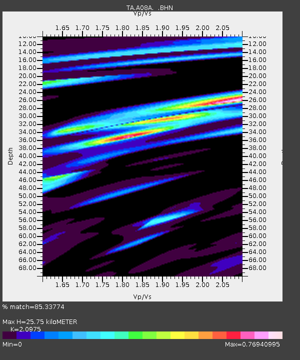
| Estimated Moho Depth: |
25.75 km |
| Estimated Crust Vp/Vs: |
2.10 |
| Assumed Crust Vp: |
6.419 km/s |
| Estimated Crust Vs: |
3.06 km/s |
| Estimated Crust Poisson's Ratio: |
0.35 |
|
| Radial Match: |
85.33774 % |
| Radial Bump: |
284 |
| Transverse Match: |
70.0284 % |
| Transverse Bump: |
400 |
| SOD ConfigId: |
2564 |
| Insert Time: |
2010-03-07 04:06:26.764 +0000 |
| GWidth: |
2.5 |
| Max Bumps: |
400 |
| Tol: |
0.001 |
|

Signal To Noise
| Channel | StoN | STA | LTA |
| TA:A08A: :BHN:20080221T02:54:52.424006Z | 4.8609967 | 7.8414723E-7 | 1.6131408E-7 |
| TA:A08A: :BHE:20080221T02:54:52.424006Z | 0.9488766 | 1.9429275E-7 | 2.0476082E-7 |
| TA:A08A: :BHZ:20080221T02:54:52.424006Z | 3.8805585 | 1.3003006E-6 | 3.3508078E-7 |
| Arrivals |
| Ps | 4.6 SECOND |
| PpPs | 12 SECOND |
| PsPs/PpSs | 16 SECOND |


