
Station TA A08A - Turner Farm, Oroville, WA, USA
Network: TA - USArray Transportable Network (new EarthScope stations)
Nearby stations (2 deg radius)
| Station | Name | (Lat, Lon) | Start / End | Elevation |
| A08A | Turner Farm, Oroville, WA, USA | (48.95, -119.27) | 2006-09-14 / 2499-01-01 | 1.1 km |
| Crust2 Type: | Q2,orogen/39km no ice, Appalachians, North Andes, 0.5 km seds. |
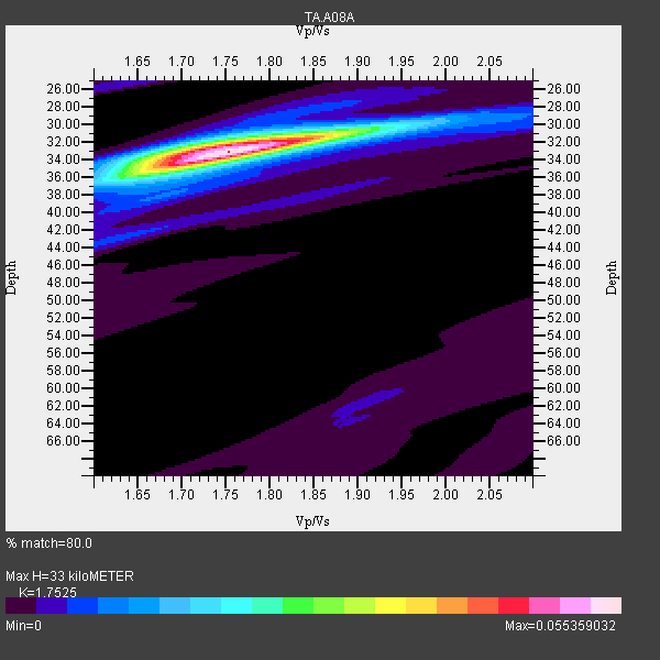
| Thickness Estimate: | 33 km |
| Thickness StdDev: | 0.4 km |
| Vp/Vs Estimate: | 1.75 |
| Vp/Vs StdDev: | 0.02 |
| Vs Estimate: | 3.663 km/s |
| Poisson's Ratio: | 0.26 |
| Peak Value: | 0.06 |
| Assumed Vp: | 6.419 km/s |
| Ps Weight: | 0.33333334 |
| PpPs Weight: | 0.33333334 |
| PsPs Weight: | 0.33333328 |
| Residual Complexity: | 0.287 |
| Nearby stations H: | +- |
| (2.0 deg) Vp/Vs: | +- |
20 with match > 90% ( 52.63158 %) and 38 with match > 80% ( 100.0 %) out of 38.
Download stack as xyz text file.
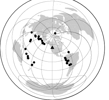
Azimuth Distribution of Events:
Prior Results for this Station
| Study | Thickness | Vp/Vs | Vp | Vs | Poissons Ratio | Extra |
| EARS | 33 km | 1.75 | 6.419 km/s | 3.663 km/s | 0.26 | |
| Crust2.0 | 39 km | 1.75 | 6.419 km/s | 3.659 km/s | 0.26 | Q2,orogen/39km no ice, Appalachians, North Andes, 0.5 km seds. |
| Global Maxima | 33 km | 1.75 | 6.419 km/s | 3.663 km/s | 0.26 | amp=0.055359032 |
| Local Maxima 1 | 32 km | 1.74 | 6.419 km/s | 3.689 km/s | 0.25 | amp=0.019844629 |
| Local Maxima 2 | 36 km | 1.64 | 6.419 km/s | 3.902 km/s | 0.21 | amp=0.011948389 |
| Local Maxima 3 | 42 km | 1.65 | 6.419 km/s | 3.885 km/s | 0.21 | amp=0.0053676018 |
| Local Maxima 4 | 26 km | 1.60 | 6.419 km/s | 4.012 km/s | 0.18 | amp=0.003917166 |
| Predicted Arrivals for vertical incidence (zero ray parameter) | |
| Ps | 3.87 SECOND |
| PpPs | 14.15 SECOND |
| PsPs/PpSs | 18.02 SECOND |
Events Processed for this Station
Download zip of receiver functions as SAC
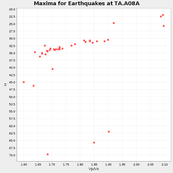
Plot maxima for each earthquake.
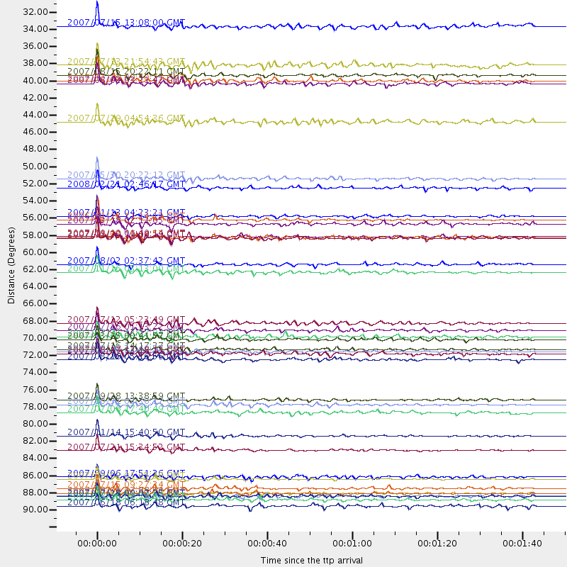
Events Used in the Stack
(38 events)| Radial Match | Distance | Baz | FERegion | Time | Lat/Lon | Depth | Magnitude |
| 98.49626 | 55.6 deg | 303.407 deg | Kuril Islands | 2006/11/15 11:14:13 GMT | (46.6, 153.3) | 10 km | 6.5 MB, 7.8 MS, 8.3 MW, 7.9 MW |
| 98.33707 | 89.0 deg | 251.157 deg | Santa Cruz Islands | 2007/09/02 01:05:18 GMT | (-11.6, 165.8) | 35 km | 5.9 MB, 7.3 MS, 7.2 MW, 6.9 ME |
| 97.38083 | 90.9 deg | 229.936 deg | South Of Fiji Islands | 2007/12/09 07:28:20 GMT | (-26.0, -177.5) | 152 km | 7.0 MB, 7.8 MW, 7.7 MW |
| 97.2588 | 83.4 deg | 134.936 deg | Northern Chile | 2007/11/14 15:40:50 GMT | (-22.2, -69.9) | 40 km | 6.7 MB, 7.4 MS, 7.7 MW, 7.4 ME |
| 96.89519 | 72.6 deg | 136.279 deg | Near Coast Of Peru | 2007/08/15 23:40:57 GMT | (-13.4, -76.6) | 39 km | 6.7 MB, 7.9 MS, 8.0 MW, 7.5 ME |
| 96.04993 | 90.9 deg | 247.204 deg | Vanuatu Islands | 2007/08/01 17:08:51 GMT | (-15.6, 167.7) | 120 km | 6.2 MB, 7.2 MW, 7.2 MW |
| 95.97886 | 55.1 deg | 302.432 deg | East Of Kuril Islands | 2007/01/13 04:23:21 GMT | (46.2, 154.5) | 10 km | 7.3 MB, 8.2 MS, 8.1 MW, 7.9 MW |
| 94.9101 | 36.9 deg | 294.847 deg | Andreanof Islands, Aleutian Is. | 2007/08/15 20:22:11 GMT | (50.3, -177.5) | 9.0 km | 6.3 MB, 6.2 MS, 6.4 MW, 5.9 ML |
| 93.91969 | 69.8 deg | 304.159 deg | Near West Coast Of Honshu, Japan | 2007/07/16 01:13:22 GMT | (37.5, 138.4) | 12 km | 6.5 MB, 6.4 MS, 6.6 MW, 6.5 MW |
| 93.85831 | 78.8 deg | 290.504 deg | Volcano Islands, Japan Region | 2007/09/28 13:38:59 GMT | (22.0, 142.7) | 276 km | 6.7 MB, 7.4 MW, 7.4 MW |
| 93.305 | 57.8 deg | 128.804 deg | Near West Coast Of Colombia | 2007/09/10 01:49:14 GMT | (3.0, -78.0) | 31 km | 6.1 MB, 6.7 MS, 6.8 MW |
| 93.192604 | 91.7 deg | 257.026 deg | Solomon Islands | 2007/08/16 08:39:27 GMT | (-9.8, 159.5) | 10 km | 6.1 MB, 6.7 MS, 6.4 MW |
| 93.09439 | 90.2 deg | 246.649 deg | Vanuatu Islands | 2007/07/15 09:27:34 GMT | (-15.4, 168.6) | 8.0 km | 6.0 MB, 5.8 MS, 6.1 MW, 6.0 MW |
| 91.96958 | 61.4 deg | 309.754 deg | Sakhalin, Russia | 2007/08/02 02:37:42 GMT | (47.1, 141.8) | 5.0 km | 6.2 MS, 5.3 MB, 6.2 MW, 6.2 MW |
| 91.63388 | 72.3 deg | 305.878 deg | Sea Of Japan | 2007/07/16 14:17:37 GMT | (36.8, 134.9) | 350 km | 6.2 MB, 6.8 MW, 6.8 MW |
| 91.50103 | 62.4 deg | 131.729 deg | Peru-Ecuador Border Region | 2007/11/16 03:13:00 GMT | (-2.3, -77.8) | 123 km | 6.3 MB, 6.8 MW, 6.7 MW |
| 91.49439 | 79.4 deg | 286.474 deg | Mariana Islands | 2007/10/31 03:30:17 GMT | (18.9, 145.4) | 223 km | 6.2 MB, 7.2 MW, 7.2 MW |
| 91.20105 | 50.3 deg | 307.279 deg | Kamchatka Peninsula, Russia | 2007/05/30 20:22:12 GMT | (52.1, 157.3) | 116 km | 6.4 MB, 6.4 MW, 6.4 MW |
| 90.89507 | 85.3 deg | 131.61 deg | Jujuy Province, Argentina | 2007/07/21 15:34:52 GMT | (-22.2, -65.8) | 290 km | 5.8 MB, 6.4 MW, 6.3 MW |
| 90.03359 | 30.6 deg | 295.397 deg | Fox Islands, Aleutian Islands | 2007/07/15 13:08:00 GMT | (52.5, -168.0) | 10 km | 5.8 MB, 5.9 MS, 6.1 MW, 6.0 MW |
| 89.384995 | 58.0 deg | 104.749 deg | Windward Islands | 2007/11/29 19:00:19 GMT | (15.0, -61.3) | 148 km | 6.9 MB, 7.4 MW, 7.4 MW |
| 88.83462 | 70.7 deg | 128.764 deg | Western Brazil | 2007/07/21 13:27:04 GMT | (-8.1, -71.3) | 645 km | 6.2 MB, 6.1 MW, 6.0 MW |
| 88.443504 | 37.7 deg | 297.189 deg | Andreanof Islands, Aleutian Is. | 2007/12/19 09:30:27 GMT | (51.4, -179.5) | 29 km | 6.4 MB, 7.1 MS, 7.1 MW, 7.0 MW |
| 87.15627 | 91.3 deg | 229.935 deg | South Of Fiji Islands | 2007/07/18 00:07:35 GMT | (-26.3, -177.7) | 10 km | 5.8 MB, 5.9 MS, 6.1 MW, 6.0 MW |
| 87.06874 | 71.0 deg | 305.164 deg | Near West Coast Of Honshu, Japan | 2007/03/25 00:41:57 GMT | (37.3, 136.6) | 8.0 km | 6.1 MB, 6.8 MS, 6.7 MW, 6.6 MW |
| 87.06126 | 91.2 deg | 229.989 deg | South Of Fiji Islands | 2007/07/17 09:39:27 GMT | (-26.2, -177.7) | 10 km | 5.7 MB, 6.0 MS, 6.1 MW, 6.0 MW |
| 86.35906 | 80.4 deg | 231.359 deg | Samoa Islands Region | 2007/07/06 17:40:49 GMT | (-16.4, -172.6) | 10 km | 5.5 MB, 5.1 MS, 5.7 MW |
| 85.33774 | 51.5 deg | 11.129 deg | Svalbard Region | 2008/02/21 02:46:17 GMT | (77.1, 18.6) | 10 km | 5.7 MB, 5.9 MS, 6.1 MW, 6.0 MW |
| 85.18305 | 68.9 deg | 131.479 deg | Peru-Brazil Border Region | 2007/07/12 05:23:49 GMT | (-7.9, -74.4) | 152 km | 5.9 MB, 6.1 MW, 6.0 MW |
| 85.10783 | 88.8 deg | 306.704 deg | Taiwan Region | 2007/09/06 17:51:26 GMT | (24.3, 122.2) | 53 km | 6.1 MB, 6.2 MW, 6.1 ME |
| 84.25656 | 57.8 deg | 304.332 deg | Kuril Islands | 2007/09/03 16:14:53 GMT | (45.8, 150.1) | 94 km | 6.3 MB, 6.2 MW, 6.2 ME |
| 83.50434 | 73.6 deg | 136.289 deg | Near Coast Of Peru | 2007/08/16 05:16:56 GMT | (-14.3, -76.1) | 23 km | 5.8 MB, 6.1 MS, 6.3 MW, 6.2 ML |
| 82.67312 | 72.8 deg | 136.383 deg | Near Coast Of Peru | 2007/08/17 13:18:13 GMT | (-13.6, -76.6) | 48 km | 5.6 MB, 5.6 MS, 5.9 MW |
| 82.506226 | 35.7 deg | 296.802 deg | Andreanof Islands, Aleutian Is. | 2007/07/13 21:54:43 GMT | (51.8, -176.3) | 35 km | 5.7 MB, 5.6 MS, 6.0 MW, 5.9 MW |
| 82.37619 | 43.0 deg | 304.293 deg | Komandorskiye Ostrova Region | 2007/07/29 04:54:36 GMT | (53.6, 169.7) | 26 km | 6.0 MB, 5.5 MS, 5.9 MW, 5.8 MW |
| 82.29318 | 92.5 deg | 267.494 deg | New Ireland Region, P.N.G. | 2007/06/18 06:18:48 GMT | (-3.6, 151.0) | 26 km | 5.7 MB, 6.2 MS, 6.3 MW, 6.1 MW |
| 81.74426 | 38.0 deg | 297.267 deg | Andreanof Islands, Aleutian Is. | 2007/08/02 03:21:42 GMT | (51.3, -180.0) | 21 km | 6.3 MB, 6.6 MS, 6.7 MW, 6.6 MW |
| 80.92838 | 56.1 deg | 128.368 deg | South Of Panama | 2007/03/18 02:11:05 GMT | (4.6, -78.5) | 8.0 km | 6.4 MB, 5.7 MS, 6.2 MW, 6.1 MW |
Losers
(0 events)| Radial Match | Distance | Baz | FERegion | Time | Lat/Lon | Depth | Magnitude | Reason |
