You are here: Home > Network List > TA - USArray Transportable Network (new EarthScope stations) Stations List
> Station A08A Turner Farm, Oroville, WA, USA > Earthquake Result Viewer
A08A Turner Farm, Oroville, WA, USA - Earthquake Result Viewer
| Earthquake location: |
Near West Coast Of Colombia |
| Earthquake latitude/longitude: |
3.0/-78.0 |
| Earthquake time(UTC): |
2007/09/10 (253) 01:49:14 GMT |
| Earthquake Depth: |
31 km |
| Earthquake Magnitude: |
6.1 MB, 6.7 MS, 6.8 MW |
| Earthquake Catalog/Contributor: |
WHDF/NEIC |
|
| Network: |
TA USArray Transportable Network (new EarthScope stations) |
| Station: |
A08A Turner Farm, Oroville, WA, USA |
| Lat/Lon: |
48.95 N/119.27 W |
| Elevation: |
1089 m |
|
| Distance: |
57.8 deg |
| Az: |
329.044 deg |
| Baz: |
128.804 deg |
| Ray Param: |
0.06322973 |
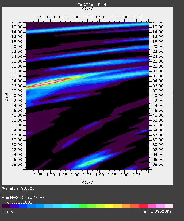
| Estimated Moho Depth: |
34.5 km |
| Estimated Crust Vp/Vs: |
1.69 |
| Assumed Crust Vp: |
6.419 km/s |
| Estimated Crust Vs: |
3.81 km/s |
| Estimated Crust Poisson's Ratio: |
0.23 |
|
| Radial Match: |
93.305 % |
| Radial Bump: |
322 |
| Transverse Match: |
80.80732 % |
| Transverse Bump: |
400 |
| SOD ConfigId: |
2564 |
| Insert Time: |
2010-03-07 04:06:41.313 +0000 |
| GWidth: |
2.5 |
| Max Bumps: |
400 |
| Tol: |
0.001 |
|
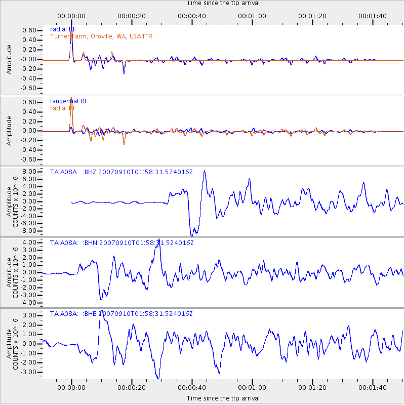
Signal To Noise
| Channel | StoN | STA | LTA |
| TA:A08A: :BHN:20070910T01:58:31.524016Z | 5.816434 | 5.2252244E-7 | 8.983554E-8 |
| TA:A08A: :BHE:20070910T01:58:31.524016Z | 2.4512851 | 4.6885953E-7 | 1.9127091E-7 |
| TA:A08A: :BHZ:20070910T01:58:31.524016Z | 8.329771 | 1.4358347E-6 | 1.7237386E-7 |
| Arrivals |
| Ps | 3.9 SECOND |
| PpPs | 14 SECOND |
| PsPs/PpSs | 18 SECOND |


