You are here: Home > Network List > TA - USArray Transportable Network (new EarthScope stations) Stations List
> Station A08A Turner Farm, Oroville, WA, USA > Earthquake Result Viewer
A08A Turner Farm, Oroville, WA, USA - Earthquake Result Viewer
| Earthquake location: |
Andreanof Islands, Aleutian Is. |
| Earthquake latitude/longitude: |
50.3/-177.5 |
| Earthquake time(UTC): |
2007/08/15 (227) 20:22:11 GMT |
| Earthquake Depth: |
9.0 km |
| Earthquake Magnitude: |
6.3 MB, 6.2 MS, 6.4 MW, 5.9 ML |
| Earthquake Catalog/Contributor: |
WHDF/NEIC |
|
| Network: |
TA USArray Transportable Network (new EarthScope stations) |
| Station: |
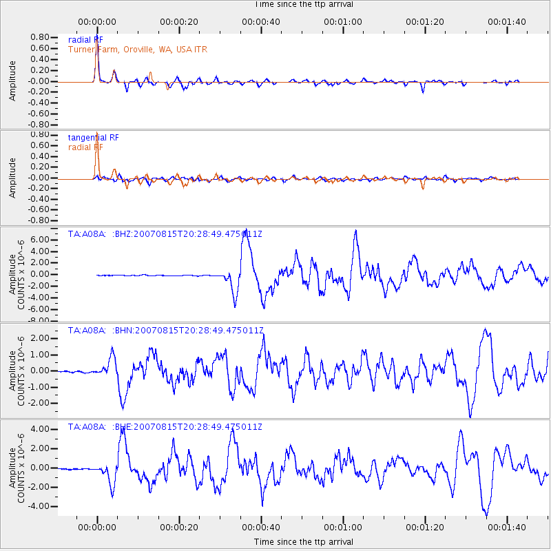
A08A Turner Farm, Oroville, WA, USA |
| Lat/Lon: |
48.95 N/119.27 W |
| Elevation: |
1089 m |
|
| Distance: |
36.9 deg |
| Az: |
68.932 deg |
| Baz: |
294.847 deg |
| Ray Param: |
0.076414526 |
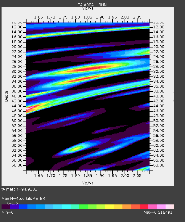
| Estimated Moho Depth: |
45.0 km |
| Estimated Crust Vp/Vs: |
1.60 |
| Assumed Crust Vp: |
6.419 km/s |
| Estimated Crust Vs: |
4.012 km/s |
| Estimated Crust Poisson's Ratio: |
0.18 |
|
| Radial Match: |
94.9101 % |
| Radial Bump: |
294 |
| Transverse Match: |
76.59413 % |
| Transverse Bump: |
400 |
| SOD ConfigId: |
2564 |
| Insert Time: |
2010-03-07 04:06:53.096 +0000 |
| GWidth: |
2.5 |
| Max Bumps: |
400 |
| Tol: |
0.001 |
|
Signal To Noise
| Channel | StoN | STA | LTA |
| TA:A08A: :BHN:20070815T20:28:49.475011Z | 18.60986 | 5.9011444E-7 | 3.1709774E-8 |
| TA:A08A: :BHE:20070815T20:28:49.475011Z | 28.690588 | 1.1265224E-6 | 3.926453E-8 |
| TA:A08A: :BHZ:20070815T20:28:49.475011Z | 40.058983 | 2.0943633E-6 | 5.228199E-8 |
| Arrivals |
| Ps | 4.6 SECOND |
| PpPs | 17 SECOND |
| PsPs/PpSs | 21 SECOND |


