You are here: Home > Network List > TA - USArray Transportable Network (new EarthScope stations) Stations List
> Station A08A Turner Farm, Oroville, WA, USA > Earthquake Result Viewer
A08A Turner Farm, Oroville, WA, USA - Earthquake Result Viewer
| Earthquake location: |
Fox Islands, Aleutian Islands |
| Earthquake latitude/longitude: |
52.5/-168.0 |
| Earthquake time(UTC): |
2007/07/15 (196) 13:08:00 GMT |
| Earthquake Depth: |
10 km |
| Earthquake Magnitude: |
5.8 MB, 5.9 MS, 6.1 MW, 6.0 MW |
| Earthquake Catalog/Contributor: |
WHDF/NEIC |
|
| Network: |
TA USArray Transportable Network (new EarthScope stations) |
| Station: |
A08A Turner Farm, Oroville, WA, USA |
| Lat/Lon: |
48.95 N/119.27 W |
| Elevation: |
1089 m |
|
| Distance: |
30.6 deg |
| Az: |
76.804 deg |
| Baz: |
295.397 deg |
| Ray Param: |
0.07928623 |
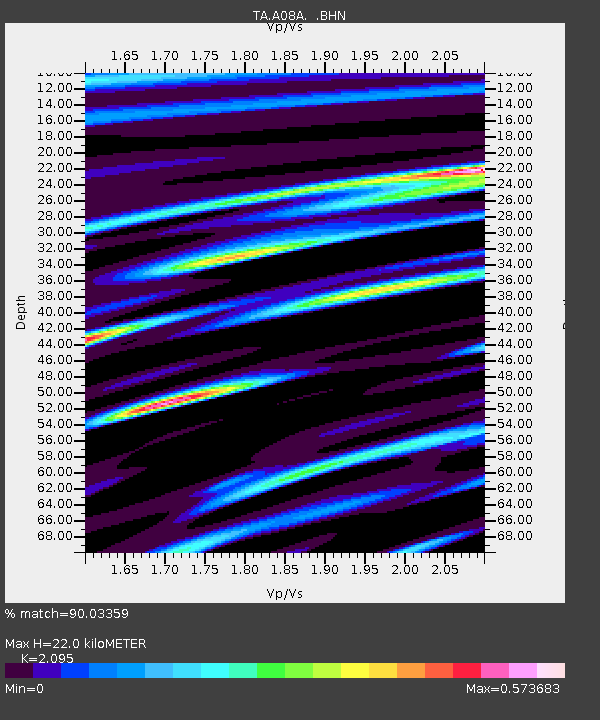
| Estimated Moho Depth: |
22.0 km |
| Estimated Crust Vp/Vs: |
2.10 |
| Assumed Crust Vp: |
6.419 km/s |
| Estimated Crust Vs: |
3.064 km/s |
| Estimated Crust Poisson's Ratio: |
0.35 |
|
| Radial Match: |
90.03359 % |
| Radial Bump: |
400 |
| Transverse Match: |
70.773285 % |
| Transverse Bump: |
400 |
| SOD ConfigId: |
2564 |
| Insert Time: |
2010-03-07 04:07:11.012 +0000 |
| GWidth: |
2.5 |
| Max Bumps: |
400 |
| Tol: |
0.001 |
|

Signal To Noise
| Channel | StoN | STA | LTA |
| TA:A08A: :BHN:20070715T13:13:44.273013Z | 2.0810256 | 7.551762E-8 | 3.6288654E-8 |
| TA:A08A: :BHE:20070715T13:13:44.273013Z | 3.343974 | 9.034391E-8 | 2.7016927E-8 |
| TA:A08A: :BHZ:20070715T13:13:44.273013Z | 3.2751138 | 1.5650724E-7 | 4.778681E-8 |
| Arrivals |
| Ps | 4.0 SECOND |
| PpPs | 9.9 SECOND |
| PsPs/PpSs | 14 SECOND |


