You are here: Home > Network List > TA - USArray Transportable Network (new EarthScope stations) Stations List
> Station A08A Turner Farm, Oroville, WA, USA > Earthquake Result Viewer
A08A Turner Farm, Oroville, WA, USA - Earthquake Result Viewer
| Earthquake location: |
Vanuatu Islands |
| Earthquake latitude/longitude: |
-15.4/168.6 |
| Earthquake time(UTC): |
2007/07/15 (196) 09:27:34 GMT |
| Earthquake Depth: |
8.0 km |
| Earthquake Magnitude: |
6.0 MB, 5.8 MS, 6.1 MW, 6.0 MW |
| Earthquake Catalog/Contributor: |
WHDF/NEIC |
|
| Network: |
TA USArray Transportable Network (new EarthScope stations) |
| Station: |
A08A Turner Farm, Oroville, WA, USA |
| Lat/Lon: |
48.95 N/119.27 W |
| Elevation: |
1089 m |
|
| Distance: |
90.2 deg |
| Az: |
38.857 deg |
| Baz: |
246.649 deg |
| Ray Param: |
0.04169217 |
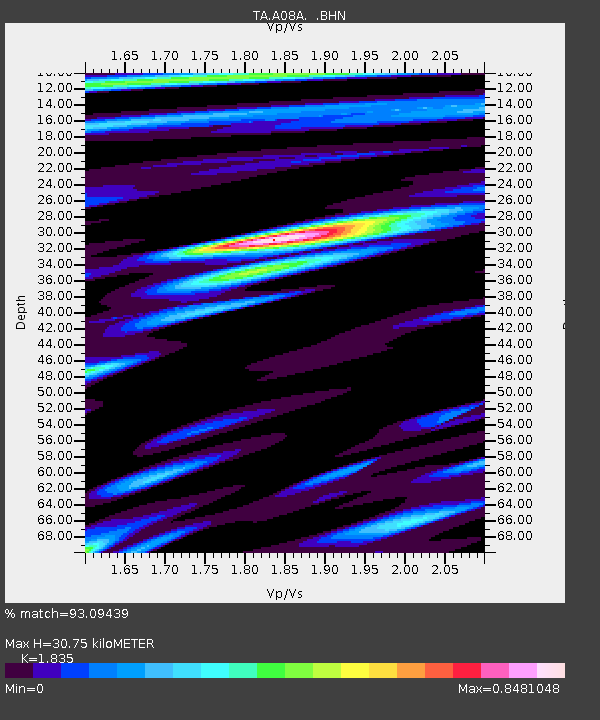
| Estimated Moho Depth: |
30.75 km |
| Estimated Crust Vp/Vs: |
1.84 |
| Assumed Crust Vp: |
6.419 km/s |
| Estimated Crust Vs: |
3.498 km/s |
| Estimated Crust Poisson's Ratio: |
0.29 |
|
| Radial Match: |
93.09439 % |
| Radial Bump: |
331 |
| Transverse Match: |
84.73188 % |
| Transverse Bump: |
400 |
| SOD ConfigId: |
2564 |
| Insert Time: |
2010-03-07 04:07:12.425 +0000 |
| GWidth: |
2.5 |
| Max Bumps: |
400 |
| Tol: |
0.001 |
|

Signal To Noise
| Channel | StoN | STA | LTA |
| TA:A08A: :BHN:20070715T09:40:03.675007Z | 9.352233 | 3.9054663E-7 | 4.175972E-8 |
| TA:A08A: :BHE:20070715T09:40:03.675007Z | 10.772496 | 6.306488E-7 | 5.8542494E-8 |
| TA:A08A: :BHZ:20070715T09:40:03.675007Z | 51.308815 | 2.1582482E-6 | 4.2063885E-8 |
| Arrivals |
| Ps | 4.1 SECOND |
| PpPs | 13 SECOND |
| PsPs/PpSs | 17 SECOND |


