You are here: Home > Network List > TA - USArray Transportable Network (new EarthScope stations) Stations List
> Station A08A Turner Farm, Oroville, WA, USA > Earthquake Result Viewer
A08A Turner Farm, Oroville, WA, USA - Earthquake Result Viewer
| Earthquake location: |
New Ireland Region, P.N.G. |
| Earthquake latitude/longitude: |
-3.6/151.0 |
| Earthquake time(UTC): |
2007/06/18 (169) 06:18:48 GMT |
| Earthquake Depth: |
26 km |
| Earthquake Magnitude: |
5.7 MB, 6.2 MS, 6.3 MW, 6.1 MW |
| Earthquake Catalog/Contributor: |
WHDF/NEIC |
|
| Network: |
TA USArray Transportable Network (new EarthScope stations) |
| Station: |
A08A Turner Farm, Oroville, WA, USA |
| Lat/Lon: |
48.95 N/119.27 W |
| Elevation: |
1089 m |
|
| Distance: |
92.5 deg |
| Az: |
41.285 deg |
| Baz: |
267.494 deg |
| Ray Param: |
0.041436084 |
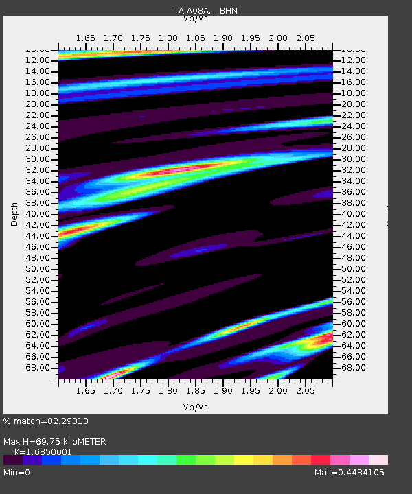
| Estimated Moho Depth: |
69.75 km |
| Estimated Crust Vp/Vs: |
1.69 |
| Assumed Crust Vp: |
6.419 km/s |
| Estimated Crust Vs: |
3.81 km/s |
| Estimated Crust Poisson's Ratio: |
0.23 |
|
| Radial Match: |
82.29318 % |
| Radial Bump: |
400 |
| Transverse Match: |
60.837406 % |
| Transverse Bump: |
400 |
| SOD ConfigId: |
2564 |
| Insert Time: |
2010-03-07 04:07:20.570 +0000 |
| GWidth: |
2.5 |
| Max Bumps: |
400 |
| Tol: |
0.001 |
|
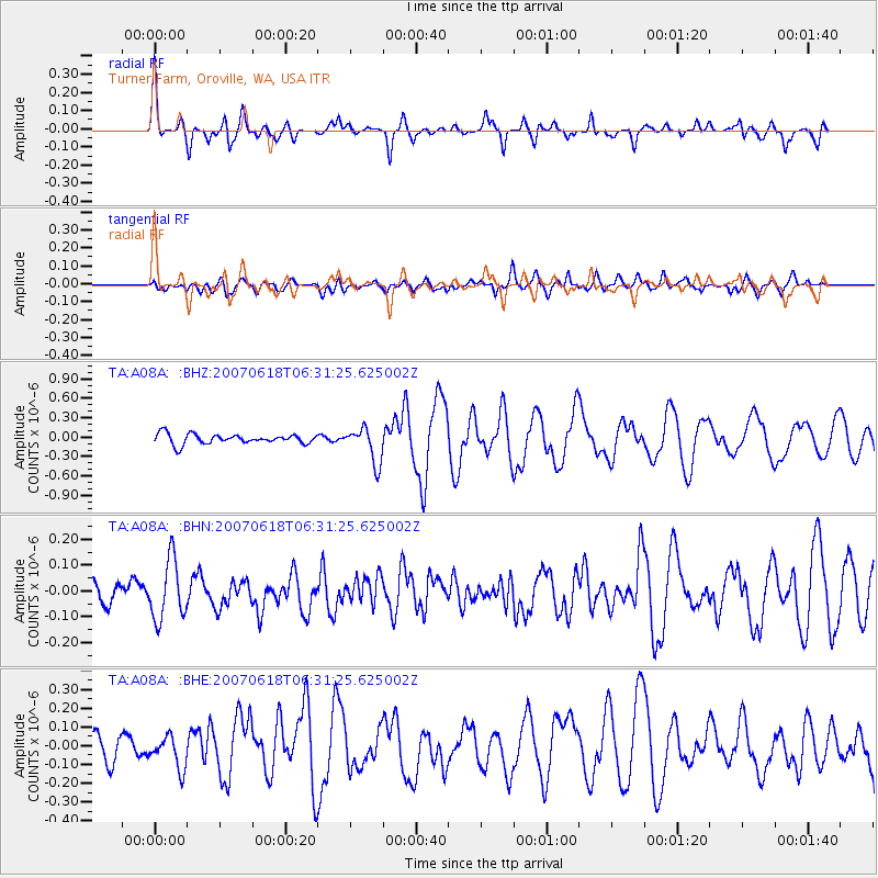
Signal To Noise
| Channel | StoN | STA | LTA |
| TA:A08A: :BHN:20070618T06:31:25.625002Z | 2.4303064 | 1.1612426E-7 | 4.7781736E-8 |
| TA:A08A: :BHE:20070618T06:31:25.625002Z | 1.6524647 | 8.5030095E-8 | 5.1456524E-8 |
| TA:A08A: :BHZ:20070618T06:31:25.625002Z | 3.560974 | 2.717506E-7 | 7.631356E-8 |
| Arrivals |
| Ps | 7.6 SECOND |
| PpPs | 29 SECOND |
| PsPs/PpSs | 36 SECOND |


