You are here: Home > Network List > TA - USArray Transportable Network (new EarthScope stations) Stations List
> Station R10A Warm Springs, NV, USA > Earthquake Result Viewer
R10A Warm Springs, NV, USA - Earthquake Result Viewer
| Earthquake location: |
Windward Islands |
| Earthquake latitude/longitude: |
15.0/-61.3 |
| Earthquake time(UTC): |
2007/11/29 (333) 19:00:19 GMT |
| Earthquake Depth: |
148 km |
| Earthquake Magnitude: |
6.9 MB, 7.4 MW, 7.4 MW |
| Earthquake Catalog/Contributor: |
WHDF/NEIC |
|
| Network: |
TA USArray Transportable Network (new EarthScope stations) |
| Station: |
R10A Warm Springs, NV, USA |
| Lat/Lon: |
38.29 N/116.30 W |
| Elevation: |
1600 m |
|
| Distance: |
53.5 deg |
| Az: |
306.694 deg |
| Baz: |
100.002 deg |
| Ray Param: |
0.06553747 |
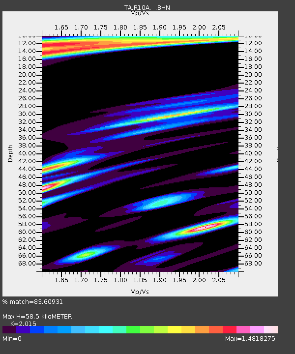
| Estimated Moho Depth: |
58.5 km |
| Estimated Crust Vp/Vs: |
2.02 |
| Assumed Crust Vp: |
6.276 km/s |
| Estimated Crust Vs: |
3.115 km/s |
| Estimated Crust Poisson's Ratio: |
0.34 |
|
| Radial Match: |
83.60931 % |
| Radial Bump: |
400 |
| Transverse Match: |
85.20808 % |
| Transverse Bump: |
400 |
| SOD ConfigId: |
2564 |
| Insert Time: |
2010-03-07 04:09:37.595 +0000 |
| GWidth: |
2.5 |
| Max Bumps: |
400 |
| Tol: |
0.001 |
|
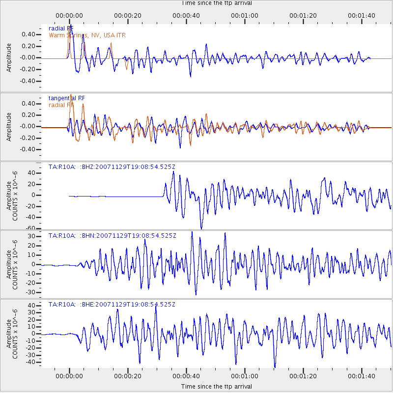
Signal To Noise
| Channel | StoN | STA | LTA |
| TA:R10A: :BHN:20071129T19:08:54.525Z | 2.9368913 | 8.821558E-7 | 3.003706E-7 |
| TA:R10A: :BHE:20071129T19:08:54.525Z | 10.085141 | 4.693148E-6 | 4.6535277E-7 |
| TA:R10A: :BHZ:20071129T19:08:54.525Z | 29.784996 | 8.105013E-6 | 2.7211732E-7 |
| Arrivals |
| Ps | 9.9 SECOND |
| PpPs | 27 SECOND |
| PsPs/PpSs | 37 SECOND |


