
Station TA R10A - Warm Springs, NV, USA
Network: TA - USArray Transportable Network (new EarthScope stations)
Nearby stations (2 deg radius)
| Station | Name | (Lat, Lon) | Start / End | Elevation |
| R10A | Warm Springs, NV, USA | (38.29, -116.30) | 2006-06-09 / 2499-01-01 | 1.6 km |
| Crust2 Type: | M5,extended crust, 0.5 km seds. |
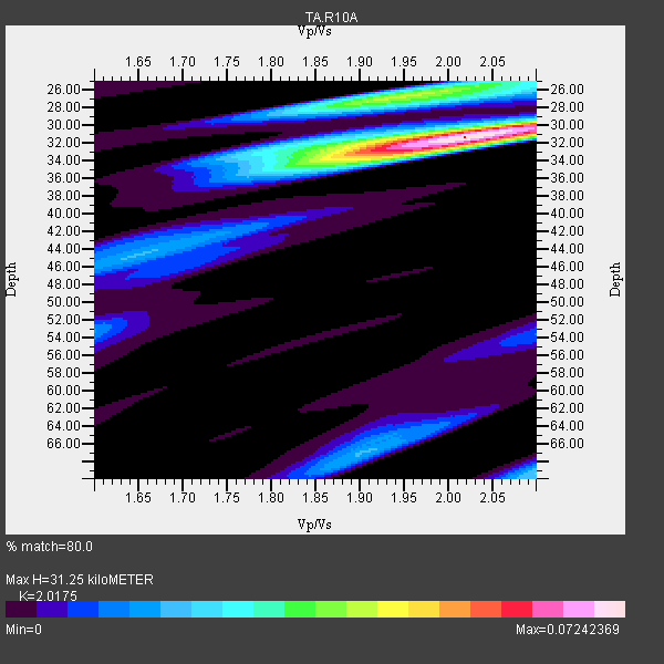
| Thickness Estimate: | 31 km |
| Thickness StdDev: | 0.6 km |
| Vp/Vs Estimate: | 2.02 |
| Vp/Vs StdDev: | 0.03 |
| Vs Estimate: | 3.111 km/s |
| Poisson's Ratio: | 0.34 |
| Peak Value: | 0.07 |
| Assumed Vp: | 6.276 km/s |
| Ps Weight: | 0.33333334 |
| PpPs Weight: | 0.33333334 |
| PsPs Weight: | 0.33333328 |
| Residual Complexity: | 0.597 |
| Nearby stations H: | +- |
| (2.0 deg) Vp/Vs: | +- |
2 with match > 90% ( 8.333333 %) and 24 with match > 80% ( 100.0 %) out of 24.
Download stack as xyz text file.
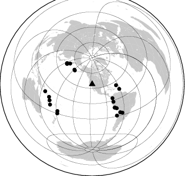
Azimuth Distribution of Events:
Prior Results for this Station
| Study | Thickness | Vp/Vs | Vp | Vs | Poissons Ratio | Extra |
| EARS | 31 km | 2.02 | 6.276 km/s | 3.111 km/s | 0.34 | |
| Crust2.0 | 31 km | 1.78 | 6.276 km/s | 3.529 km/s | 0.27 | M5,extended crust, 0.5 km seds. |
| Global Maxima | 31 km | 2.02 | 6.276 km/s | 3.111 km/s | 0.34 | amp=0.07242369 |
| Local Maxima 1 | 27 km | 1.94 | 6.276 km/s | 3.235 km/s | 0.32 | amp=0.041858315 |
| Local Maxima 2 | 34 km | 1.92 | 6.276 km/s | 3.273 km/s | 0.31 | amp=0.029434849 |
| Local Maxima 3 | 69 km | 2.10 | 6.276 km/s | 2.992 km/s | 0.35 | amp=0.020279588 |
| Local Maxima 4 | 32 km | 1.91 | 6.276 km/s | 3.281 km/s | 0.31 | amp=0.019848283 |
| Predicted Arrivals for vertical incidence (zero ray parameter) | |
| Ps | 5.07 SECOND |
| PpPs | 15.03 SECOND |
| PsPs/PpSs | 20.09 SECOND |
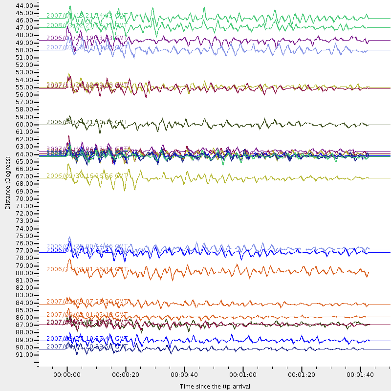
Events Processed for this Station
Download zip of receiver functions as SAC
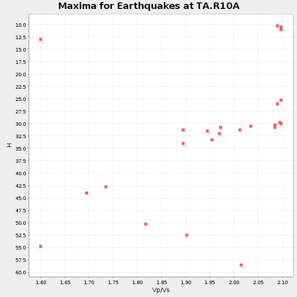
Plot maxima for each earthquake.
Events Used in the Stack
(24 events)| Radial Match | Distance | Baz | FERegion | Time | Lat/Lon | Depth | Magnitude |
| 96.47566 | 63.7 deg | 309.727 deg | Kuril Islands | 2006/11/15 11:14:13 GMT | (46.6, 153.3) | 10 km | 6.5 MB, 7.8 MS, 8.3 MW, 7.9 MW |
| 91.97682 | 63.1 deg | 308.921 deg | East Of Kuril Islands | 2007/01/13 04:23:21 GMT | (46.2, 154.5) | 10 km | 7.3 MB, 8.2 MS, 8.1 MW, 7.9 MW |
| 88.46982 | 63.4 deg | 136.082 deg | Near Coast Of Peru | 2006/10/20 10:48:56 GMT | (-13.5, -76.7) | 23 km | 5.9 MB, 6.6 MS, 6.7 MW, 6.6 MW |
| 87.94871 | 92.6 deg | 261.327 deg | Solomon Islands | 2007/04/01 20:39:56 GMT | (-8.5, 157.0) | 10 km | 6.8 MB, 7.9 MS, 8.1 MW, 7.7 ME |
| 87.83552 | 77.6 deg | 134.978 deg | Chile-Argentina Border Region | 2006/08/25 00:44:46 GMT | (-24.4, -67.0) | 184 km | 5.9 MB, 6.6 MW, 6.6 MW |
| 86.34856 | 67.1 deg | 134.342 deg | Southern Peru | 2006/09/30 16:26:56 GMT | (-15.6, -73.2) | 107 km | 5.6 MB, 6.0 MW, 5.9 MW |
| 86.10667 | 88.9 deg | 249.27 deg | Vanuatu Islands | 2007/08/01 17:08:51 GMT | (-15.6, 167.7) | 120 km | 6.2 MB, 7.2 MW, 7.2 MW |
| 86.0491 | 44.7 deg | 309.131 deg | Andreanof Islands, Aleutian Is. | 2008/03/22 21:24:11 GMT | (52.2, -178.7) | 132 km | 5.8 MB, 6.2 MW, 6.1 MW |
| 85.73049 | 48.0 deg | 124.731 deg | South Of Panama | 2007/03/18 02:11:05 GMT | (4.6, -78.5) | 8.0 km | 6.4 MB, 5.7 MS, 6.2 MW, 6.1 MW |
| 85.63628 | 63.9 deg | 309.579 deg | Kuril Islands | 2008/03/03 09:31:02 GMT | (46.4, 153.2) | 10 km | 6.2 MB, 6.5 MS, 6.5 MW, 6.5 MW |
| 85.531746 | 87.8 deg | 253.506 deg | Santa Cruz Islands | 2007/09/02 01:05:18 GMT | (-11.6, 165.8) | 35 km | 5.9 MB, 7.3 MS, 7.2 MW, 6.9 ME |
| 85.22234 | 78.2 deg | 141.64 deg | Off Coast Of Central Chile | 2006/07/16 11:42:41 GMT | (-28.7, -72.5) | 10 km | 5.9 MB, 5.7 MS, 6.2 MW, 6.2 MW |
| 85.178154 | 53.8 deg | 129.607 deg | Peru-Ecuador Border Region | 2007/11/16 03:13:00 GMT | (-2.3, -77.8) | 123 km | 6.3 MB, 6.8 MW, 6.7 MW |
| 84.40037 | 88.9 deg | 229.964 deg | Kermadec Islands, New Zealand | 2007/01/31 03:15:52 GMT | (-29.8, -178.0) | 34 km | 6.1 MB, 6.3 MS, 6.5 MW, 6.4 MW |
| 84.26776 | 81.0 deg | 133.269 deg | Santiago Del Estero Prov., Arg. | 2006/11/13 01:26:34 GMT | (-26.0, -63.2) | 552 km | 6.3 MB, 6.8 MW, 6.8 MW |
| 83.8701 | 85.9 deg | 232.261 deg | South Of Fiji Islands | 2007/12/09 07:28:20 GMT | (-26.0, -177.5) | 152 km | 7.0 MB, 7.8 MW, 7.7 MW |
| 83.60931 | 53.5 deg | 100.002 deg | Windward Islands | 2007/11/29 19:00:19 GMT | (15.0, -61.3) | 148 km | 6.9 MB, 7.4 MW, 7.4 MW |
| 82.89122 | 46.7 deg | 92.556 deg | North Atlantic Ocean | 2006/07/29 19:53:43 GMT | (23.6, -63.9) | 10 km | 5.5 MB, 5.0 MS, 5.8 MW, 5.6 MW |
| 82.351265 | 63.9 deg | 309.39 deg | Kuril Islands | 2006/10/13 13:47:39 GMT | (46.3, 153.3) | 8.0 km | 5.5 MB, 5.8 MS, 6.3 MW, 5.8 MW |
| 82.34272 | 91.3 deg | 244.113 deg | Southeast Of Loyalty Islands | 2007/09/27 19:57:44 GMT | (-21.1, 169.3) | 9.0 km | 6.2 MB, 6.3 MS, 6.1 MW, 6.1 MW |
| 82.31578 | 43.3 deg | 308.387 deg | Andreanof Islands, Aleutian Is. | 2007/07/13 21:54:43 GMT | (51.8, -176.3) | 35 km | 5.7 MB, 5.6 MS, 6.0 MW, 5.9 MW |
| 81.9216 | 59.2 deg | 312.962 deg | Near East Coast Of Kamchatka | 2006/08/24 21:50:36 GMT | (51.1, 157.5) | 43 km | 5.9 MB, 6.2 MS, 6.5 MW, 6.5 MW |
| 81.20357 | 63.8 deg | 309.617 deg | Kuril Islands | 2006/10/01 09:06:02 GMT | (46.5, 153.2) | 19 km | 6.1 MB, 6.4 MS, 6.6 MW, 6.5 MW |
| 80.21929 | 63.6 deg | 136.105 deg | Near Coast Of Peru | 2007/08/17 13:18:13 GMT | (-13.6, -76.6) | 48 km | 5.6 MB, 5.6 MS, 5.9 MW |
Losers
(0 events)| Radial Match | Distance | Baz | FERegion | Time | Lat/Lon | Depth | Magnitude | Reason |
