You are here: Home > Network List > TA - USArray Transportable Network (new EarthScope stations) Stations List
> Station R10A Warm Springs, NV, USA > Earthquake Result Viewer
R10A Warm Springs, NV, USA - Earthquake Result Viewer
| Earthquake location: |
Vanuatu Islands |
| Earthquake latitude/longitude: |
-15.6/167.7 |
| Earthquake time(UTC): |
2007/08/01 (213) 17:08:51 GMT |
| Earthquake Depth: |
120 km |
| Earthquake Magnitude: |
6.2 MB, 7.2 MW, 7.2 MW |
| Earthquake Catalog/Contributor: |
WHDF/NEIC |
|
| Network: |
TA USArray Transportable Network (new EarthScope stations) |
| Station: |
R10A Warm Springs, NV, USA |
| Lat/Lon: |
38.29 N/116.30 W |
| Elevation: |
1600 m |
|
| Distance: |
88.9 deg |
| Az: |
49.794 deg |
| Baz: |
249.27 deg |
| Ray Param: |
0.0419578 |
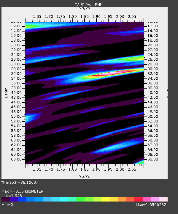
| Estimated Moho Depth: |
31.5 km |
| Estimated Crust Vp/Vs: |
1.95 |
| Assumed Crust Vp: |
6.276 km/s |
| Estimated Crust Vs: |
3.227 km/s |
| Estimated Crust Poisson's Ratio: |
0.32 |
|
| Radial Match: |
86.10667 % |
| Radial Bump: |
400 |
| Transverse Match: |
84.59843 % |
| Transverse Bump: |
400 |
| SOD ConfigId: |
2564 |
| Insert Time: |
2010-03-07 04:09:45.425 +0000 |
| GWidth: |
2.5 |
| Max Bumps: |
400 |
| Tol: |
0.001 |
|
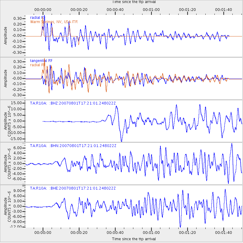
Signal To Noise
| Channel | StoN | STA | LTA |
| TA:R10A: :BHN:20070801T17:21:01.248022Z | 0.49617073 | 1.1928852E-7 | 2.4041827E-7 |
| TA:R10A: :BHE:20070801T17:21:01.248022Z | 0.6823645 | 1.176664E-7 | 1.7243921E-7 |
| TA:R10A: :BHZ:20070801T17:21:01.248022Z | 4.323851 | 6.192411E-7 | 1.4321519E-7 |
| Arrivals |
| Ps | 4.8 SECOND |
| PpPs | 15 SECOND |
| PsPs/PpSs | 19 SECOND |


