You are here: Home > Network List > TA - USArray Transportable Network (new EarthScope stations) Stations List
> Station R10A Warm Springs, NV, USA > Earthquake Result Viewer
R10A Warm Springs, NV, USA - Earthquake Result Viewer
| Earthquake location: |
South Of Panama |
| Earthquake latitude/longitude: |
4.6/-78.5 |
| Earthquake time(UTC): |
2007/03/18 (077) 02:11:05 GMT |
| Earthquake Depth: |
8.0 km |
| Earthquake Magnitude: |
6.4 MB, 5.7 MS, 6.2 MW, 6.1 MW |
| Earthquake Catalog/Contributor: |
WHDF/NEIC |
|
| Network: |
TA USArray Transportable Network (new EarthScope stations) |
| Station: |
R10A Warm Springs, NV, USA |
| Lat/Lon: |
38.29 N/116.30 W |
| Elevation: |
1600 m |
|
| Distance: |
48.0 deg |
| Az: |
319.551 deg |
| Baz: |
124.731 deg |
| Ray Param: |
0.06962624 |
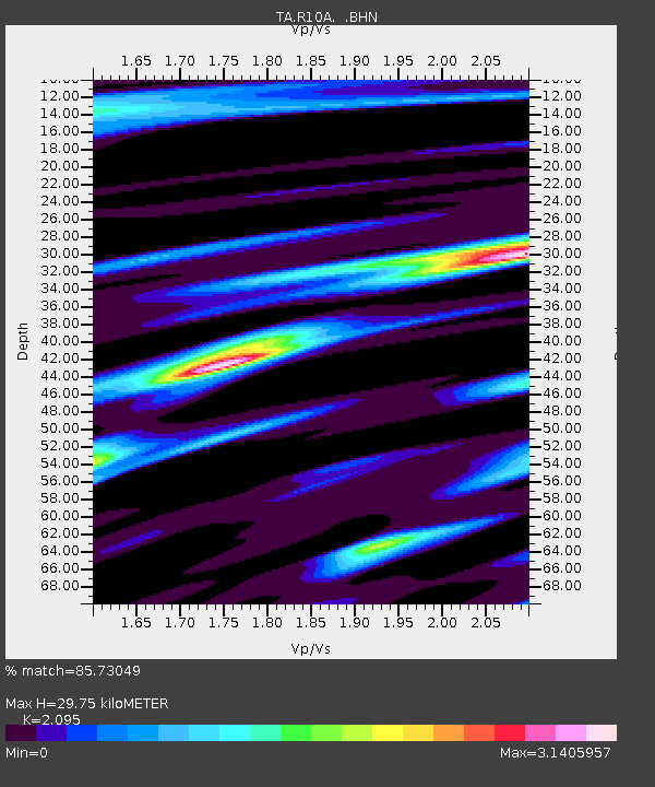
| Estimated Moho Depth: |
29.75 km |
| Estimated Crust Vp/Vs: |
2.10 |
| Assumed Crust Vp: |
6.276 km/s |
| Estimated Crust Vs: |
2.996 km/s |
| Estimated Crust Poisson's Ratio: |
0.35 |
|
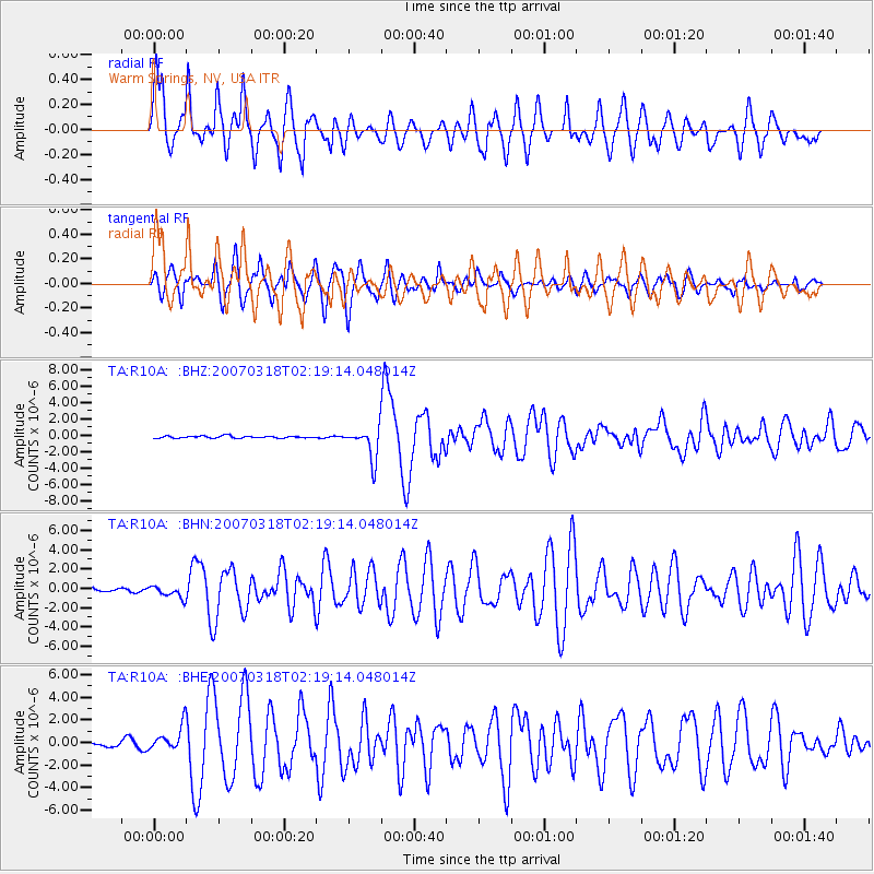
| Radial Match: |
85.73049 % |
| Radial Bump: |
400 |
| Transverse Match: |
74.70967 % |
| Transverse Bump: |
400 |
| SOD ConfigId: |
2564 |
| Insert Time: |
2010-03-07 04:09:50.178 +0000 |
| GWidth: |
2.5 |
| Max Bumps: |
400 |
| Tol: |
0.001 |
|
Signal To Noise
| Channel | StoN | STA | LTA |
| TA:R10A: :BHN:20070318T02:19:14.048014Z | 2.7959409 | 6.288447E-7 | 2.2491345E-7 |
| TA:R10A: :BHE:20070318T02:19:14.048014Z | 4.0339904 | 1.108792E-6 | 2.7486234E-7 |
| TA:R10A: :BHZ:20070318T02:19:14.048014Z | 14.53948 | 1.9538056E-6 | 1.3437933E-7 |
| Arrivals |
| Ps | 5.4 SECOND |
| PpPs | 14 SECOND |
| PsPs/PpSs | 19 SECOND |


