You are here: Home > Network List > TA - USArray Transportable Network (new EarthScope stations) Stations List
> Station R10A Warm Springs, NV, USA > Earthquake Result Viewer
R10A Warm Springs, NV, USA - Earthquake Result Viewer
| Earthquake location: |
Near Coast Of Peru |
| Earthquake latitude/longitude: |
-13.5/-76.7 |
| Earthquake time(UTC): |
2006/10/20 (293) 10:48:56 GMT |
| Earthquake Depth: |
23 km |
| Earthquake Magnitude: |
5.9 MB, 6.6 MS, 6.7 MW, 6.6 MW |
| Earthquake Catalog/Contributor: |
WHDF/NEIC |
|
| Network: |
TA USArray Transportable Network (new EarthScope stations) |
| Station: |
R10A Warm Springs, NV, USA |
| Lat/Lon: |
38.29 N/116.30 W |
| Elevation: |
1600 m |
|
| Distance: |
63.4 deg |
| Az: |
325.873 deg |
| Baz: |
136.082 deg |
| Ray Param: |
0.05954095 |
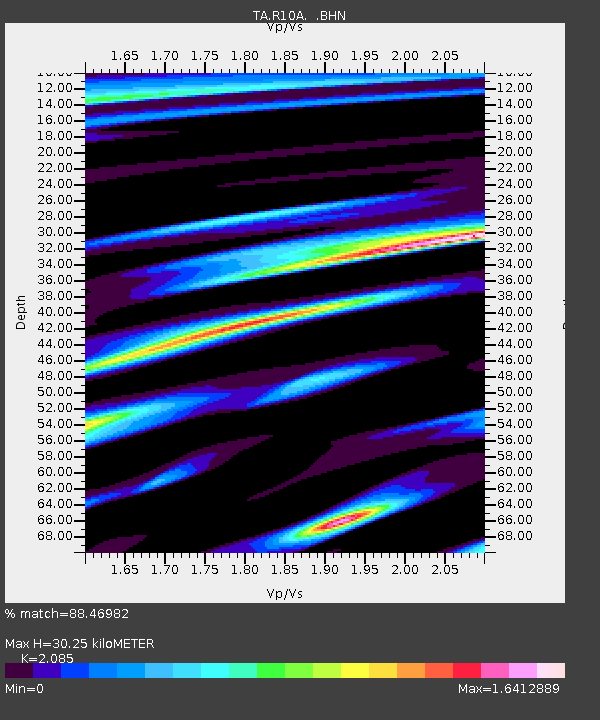
| Estimated Moho Depth: |
30.25 km |
| Estimated Crust Vp/Vs: |
2.09 |
| Assumed Crust Vp: |
6.276 km/s |
| Estimated Crust Vs: |
3.01 km/s |
| Estimated Crust Poisson's Ratio: |
0.35 |
|
| Radial Match: |
88.46982 % |
| Radial Bump: |
400 |
| Transverse Match: |
70.86928 % |
| Transverse Bump: |
400 |
| SOD ConfigId: |
2665 |
| Insert Time: |
2010-03-07 04:10:01.245 +0000 |
| GWidth: |
2.5 |
| Max Bumps: |
400 |
| Tol: |
0.001 |
|

Signal To Noise
| Channel | StoN | STA | LTA |
| TA:R10A: :BHN:20061020T10:58:52.874014Z | 1.0492554 | 4.733771E-7 | 4.5115527E-7 |
| TA:R10A: :BHE:20061020T10:58:52.874014Z | 1.0867206 | 4.3993592E-7 | 4.0482888E-7 |
| TA:R10A: :BHZ:20061020T10:58:52.874014Z | 5.4293094 | 1.1005667E-6 | 2.0270842E-7 |
| Arrivals |
| Ps | 5.4 SECOND |
| PpPs | 14 SECOND |
| PsPs/PpSs | 20 SECOND |


