You are here: Home > Network List > TA - USArray Transportable Network (new EarthScope stations) Stations List
> Station R10A Warm Springs, NV, USA > Earthquake Result Viewer
R10A Warm Springs, NV, USA - Earthquake Result Viewer
| Earthquake location: |
Kuril Islands |
| Earthquake latitude/longitude: |
46.5/153.2 |
| Earthquake time(UTC): |
2006/10/01 (274) 09:06:02 GMT |
| Earthquake Depth: |
19 km |
| Earthquake Magnitude: |
6.1 MB, 6.4 MS, 6.6 MW, 6.5 MW |
| Earthquake Catalog/Contributor: |
WHDF/NEIC |
|
| Network: |
TA USArray Transportable Network (new EarthScope stations) |
| Station: |
R10A Warm Springs, NV, USA |
| Lat/Lon: |
38.29 N/116.30 W |
| Elevation: |
1600 m |
|
| Distance: |
63.8 deg |
| Az: |
61.288 deg |
| Baz: |
309.617 deg |
| Ray Param: |
0.05932523 |
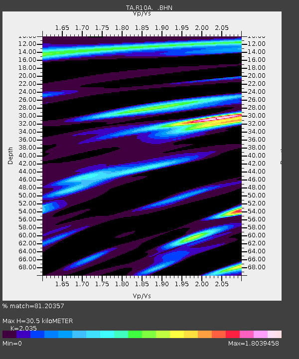
| Estimated Moho Depth: |
30.5 km |
| Estimated Crust Vp/Vs: |
2.04 |
| Assumed Crust Vp: |
6.276 km/s |
| Estimated Crust Vs: |
3.084 km/s |
| Estimated Crust Poisson's Ratio: |
0.34 |
|
| Radial Match: |
81.20357 % |
| Radial Bump: |
400 |
| Transverse Match: |
71.66856 % |
| Transverse Bump: |
400 |
| SOD ConfigId: |
2665 |
| Insert Time: |
2010-03-07 04:10:04.965 +0000 |
| GWidth: |
2.5 |
| Max Bumps: |
400 |
| Tol: |
0.001 |
|

Signal To Noise
| Channel | StoN | STA | LTA |
| TA:R10A: :BHN:20061001T09:16:01.999016Z | 1.0898958 | 3.9640346E-7 | 3.6370767E-7 |
| TA:R10A: :BHE:20061001T09:16:01.999016Z | 0.95918334 | 2.589372E-7 | 2.699559E-7 |
| TA:R10A: :BHZ:20061001T09:16:01.999016Z | 4.6172085 | 8.886405E-7 | 1.924627E-7 |
| Arrivals |
| Ps | 5.2 SECOND |
| PpPs | 14 SECOND |
| PsPs/PpSs | 19 SECOND |


