You are here: Home > Network List > TA - USArray Transportable Network (new EarthScope stations) Stations List
> Station R10A Warm Springs, NV, USA > Earthquake Result Viewer
R10A Warm Springs, NV, USA - Earthquake Result Viewer
| Earthquake location: |
North Atlantic Ocean |
| Earthquake latitude/longitude: |
23.6/-63.9 |
| Earthquake time(UTC): |
2006/07/29 (210) 19:53:43 GMT |
| Earthquake Depth: |
10 km |
| Earthquake Magnitude: |
5.5 MB, 5.0 MS, 5.8 MW, 5.6 MW |
| Earthquake Catalog/Contributor: |
WHDF/NEIC |
|
| Network: |
TA USArray Transportable Network (new EarthScope stations) |
| Station: |
R10A Warm Springs, NV, USA |
| Lat/Lon: |
38.29 N/116.30 W |
| Elevation: |
1600 m |
|
| Distance: |
46.7 deg |
| Az: |
301.03 deg |
| Baz: |
92.556 deg |
| Ray Param: |
0.07050209 |
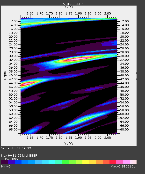
| Estimated Moho Depth: |
31.25 km |
| Estimated Crust Vp/Vs: |
1.89 |
| Assumed Crust Vp: |
6.276 km/s |
| Estimated Crust Vs: |
3.312 km/s |
| Estimated Crust Poisson's Ratio: |
0.31 |
|
| Radial Match: |
82.89122 % |
| Radial Bump: |
400 |
| Transverse Match: |
75.55816 % |
| Transverse Bump: |
353 |
| SOD ConfigId: |
2665 |
| Insert Time: |
2010-03-07 04:10:11.647 +0000 |
| GWidth: |
2.5 |
| Max Bumps: |
400 |
| Tol: |
0.001 |
|
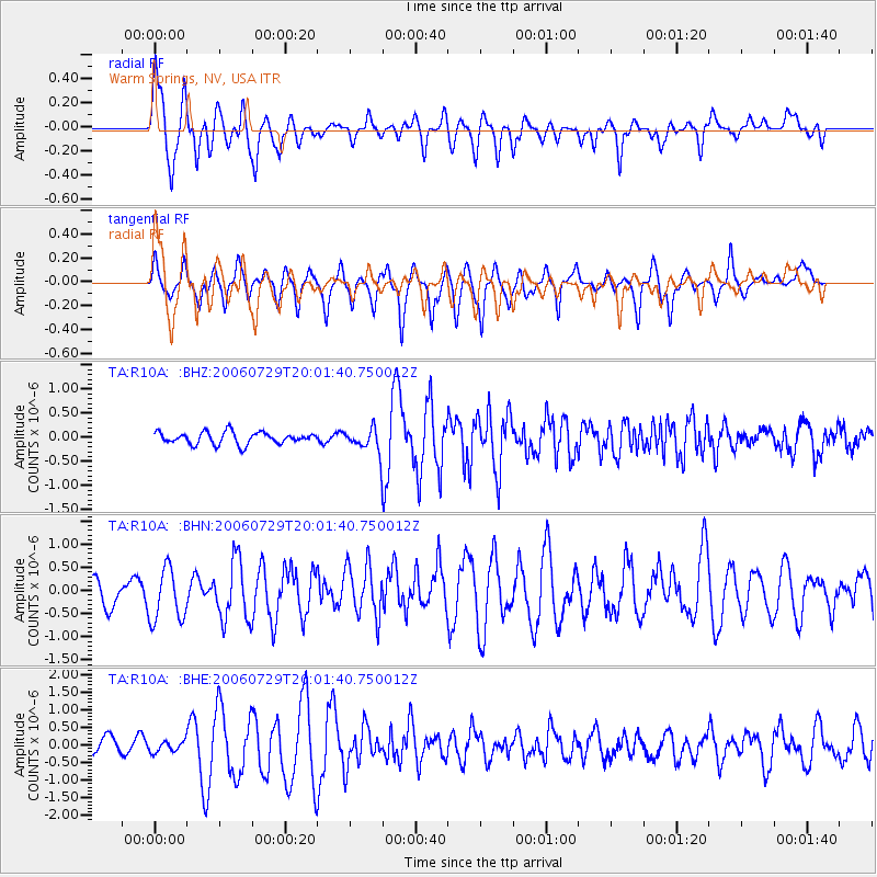
Signal To Noise
| Channel | StoN | STA | LTA |
| TA:R10A: :BHN:20060729T20:01:40.750012Z | 1.9631112 | 5.819323E-7 | 2.9643368E-7 |
| TA:R10A: :BHE:20060729T20:01:40.750012Z | 1.1156234 | 1.6228276E-7 | 1.4546376E-7 |
| TA:R10A: :BHZ:20060729T20:01:40.750012Z | 2.0361989 | 2.5213723E-7 | 1.238274E-7 |
| Arrivals |
| Ps | 4.7 SECOND |
| PpPs | 14 SECOND |
| PsPs/PpSs | 18 SECOND |


