You are here: Home > Network List > TA - USArray Transportable Network (new EarthScope stations) Stations List
> Station C06A Tall Timber Ranch, Leavenworth, WA, USA > Earthquake Result Viewer
C06A Tall Timber Ranch, Leavenworth, WA, USA - Earthquake Result Viewer
| Earthquake location: |
Northern Chile |
| Earthquake latitude/longitude: |
-22.2/-69.9 |
| Earthquake time(UTC): |
2007/11/14 (318) 15:40:50 GMT |
| Earthquake Depth: |
40 km |
| Earthquake Magnitude: |
6.7 MB, 7.4 MS, 7.7 MW, 7.4 ME |
| Earthquake Catalog/Contributor: |
WHDF/NEIC |
|
| Network: |
TA USArray Transportable Network (new EarthScope stations) |
| Station: |
C06A Tall Timber Ranch, Leavenworth, WA, USA |
| Lat/Lon: |
47.92 N/120.89 W |
| Elevation: |
594 m |
|
| Distance: |
83.5 deg |
| Az: |
328.254 deg |
| Baz: |
133.555 deg |
| Ray Param: |
0.046097457 |
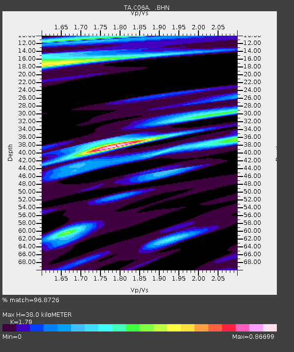
| Estimated Moho Depth: |
38.0 km |
| Estimated Crust Vp/Vs: |
1.79 |
| Assumed Crust Vp: |
6.597 km/s |
| Estimated Crust Vs: |
3.686 km/s |
| Estimated Crust Poisson's Ratio: |
0.27 |
|
| Radial Match: |
96.8726 % |
| Radial Bump: |
400 |
| Transverse Match: |
83.8932 % |
| Transverse Bump: |
400 |
| SOD ConfigId: |
2564 |
| Insert Time: |
2010-03-07 04:10:29.191 +0000 |
| GWidth: |
2.5 |
| Max Bumps: |
400 |
| Tol: |
0.001 |
|

Signal To Noise
| Channel | StoN | STA | LTA |
| TA:C06A: :BHN:20071114T15:52:42.899019Z | 6.1798687 | 9.966709E-7 | 1.6127704E-7 |
| TA:C06A: :BHE:20071114T15:52:42.899019Z | 4.227578 | 8.5073344E-7 | 2.0123422E-7 |
| TA:C06A: :BHZ:20071114T15:52:42.899019Z | 19.186651 | 3.7748036E-6 | 1.9674114E-7 |
| Arrivals |
| Ps | 4.7 SECOND |
| PpPs | 16 SECOND |
| PsPs/PpSs | 20 SECOND |


