
Station TA C06A - Tall Timber Ranch, Leavenworth, WA, USA
Network: TA - USArray Transportable Network (new EarthScope stations)
Nearby stations (2 deg radius)
| Station | Name | (Lat, Lon) | Start / End | Elevation |
| C06A | Tall Timber Ranch, Leavenworth, WA, USA | (47.92, -120.89) | 2006-09-13 / 2499-01-01 | 0.6 km |
| Crust2 Type: | L3,continental arc, Southern Andes, 0.2 km seds. |
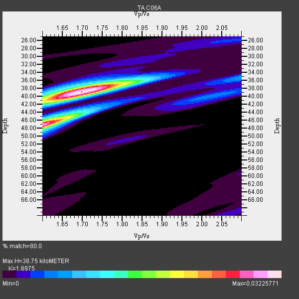
| Thickness Estimate: | 39 km |
| Thickness StdDev: | 3.8 km |
| Vp/Vs Estimate: | 1.70 |
| Vp/Vs StdDev: | 0.05 |
| Vs Estimate: | 3.887 km/s |
| Poisson's Ratio: | 0.23 |
| Peak Value: | 0.03 |
| Assumed Vp: | 6.597 km/s |
| Ps Weight: | 0.33333334 |
| PpPs Weight: | 0.33333334 |
| PsPs Weight: | 0.33333328 |
| Residual Complexity: | 0.535 |
| Nearby stations H: | +- |
| (2.0 deg) Vp/Vs: | +- |
15 with match > 90% ( 39.473682 %) and 27 with match > 80% ( 71.052635 %) out of 38.
Download stack as xyz text file.
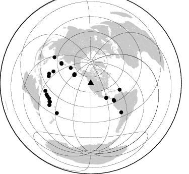
Azimuth Distribution of Events:
Prior Results for this Station
| Study | Thickness | Vp/Vs | Vp | Vs | Poissons Ratio | Extra |
| EARS | 39 km | 1.70 | 6.597 km/s | 3.887 km/s | 0.23 | |
| Crust2.0 | 40 km | 1.77 | 6.597 km/s | 3.723 km/s | 0.27 | L3,continental arc, Southern Andes, 0.2 km seds. |
| Global Maxima | 39 km | 1.70 | 6.597 km/s | 3.887 km/s | 0.23 | amp=0.03225771 |
| Local Maxima 1 | 47 km | 1.60 | 6.597 km/s | 4.117 km/s | 0.18 | amp=0.02907676 |
| Local Maxima 2 | 38 km | 1.71 | 6.597 km/s | 3.858 km/s | 0.24 | amp=0.010945965 |
| Local Maxima 3 | 41 km | 1.62 | 6.597 km/s | 4.06 km/s | 0.20 | amp=0.00809095 |
| Local Maxima 4 | 44 km | 1.70 | 6.597 km/s | 3.892 km/s | 0.23 | amp=0.006796355 |
| Predicted Arrivals for vertical incidence (zero ray parameter) | |
| Ps | 4.10 SECOND |
| PpPs | 15.84 SECOND |
| PsPs/PpSs | 19.94 SECOND |
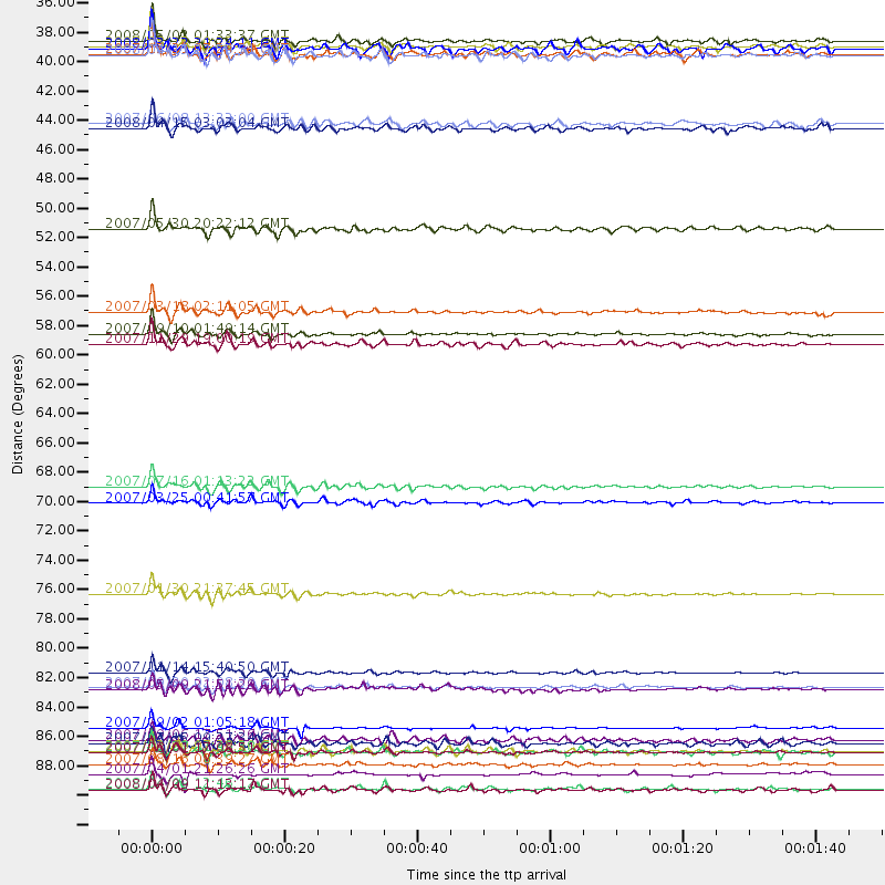
Events Processed for this Station
Download zip of receiver functions as SAC
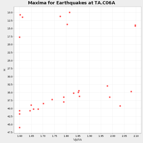
Plot maxima for each earthquake.
Events Used in the Stack
(27 events)| Radial Match | Distance | Baz | FERegion | Time | Lat/Lon | Depth | Magnitude |
| 98.845245 | 87.7 deg | 249.964 deg | Santa Cruz Islands | 2007/09/02 01:05:18 GMT | (-11.6, 165.8) | 35 km | 5.9 MB, 7.3 MS, 7.2 MW, 6.9 ME |
| 96.8726 | 83.5 deg | 133.555 deg | Northern Chile | 2007/11/14 15:40:50 GMT | (-22.2, -69.9) | 40 km | 6.7 MB, 7.4 MS, 7.7 MW, 7.4 ME |
| 95.94572 | 89.5 deg | 245.992 deg | Vanuatu Islands | 2007/08/01 17:08:51 GMT | (-15.6, 167.7) | 120 km | 6.2 MB, 7.2 MW, 7.2 MW |
| 95.55534 | 91.1 deg | 260.495 deg | Solomon Islands | 2007/04/01 21:26:26 GMT | (-7.3, 155.4) | 10 km | 5.6 MB |
| 94.72889 | 56.4 deg | 126.172 deg | South Of Panama | 2007/03/18 02:11:05 GMT | (4.6, -78.5) | 8.0 km | 6.4 MB, 5.7 MS, 6.2 MW, 6.1 MW |
| 94.44123 | 92.2 deg | 242.272 deg | Loyalty Islands | 2008/04/09 12:46:12 GMT | (-20.1, 168.9) | 33 km | 6.3 MB, 7.3 MS, 7.3 MW, 7.3 MW |
| 93.82589 | 69.5 deg | 303.489 deg | Near West Coast Of Honshu, Japan | 2007/07/16 01:13:22 GMT | (37.5, 138.4) | 12 km | 6.5 MB, 6.4 MS, 6.6 MW, 6.5 MW |
| 93.5148 | 58.0 deg | 126.667 deg | Near West Coast Of Colombia | 2007/09/10 01:49:14 GMT | (3.0, -78.0) | 31 km | 6.1 MB, 6.7 MS, 6.8 MW |
| 92.48355 | 58.8 deg | 102.763 deg | Windward Islands | 2007/11/29 19:00:19 GMT | (15.0, -61.3) | 148 km | 6.9 MB, 7.4 MW, 7.4 MW |
| 92.458786 | 89.4 deg | 228.725 deg | South Of Fiji Islands | 2007/12/09 07:28:20 GMT | (-26.0, -177.5) | 152 km | 7.0 MB, 7.8 MW, 7.7 MW |
| 91.78756 | 50.1 deg | 307.298 deg | Kamchatka Peninsula, Russia | 2007/05/30 20:22:12 GMT | (52.1, 157.3) | 116 km | 6.4 MB, 6.4 MW, 6.4 MW |
| 90.56641 | 70.7 deg | 304.463 deg | Near West Coast Of Honshu, Japan | 2007/03/25 00:41:57 GMT | (37.3, 136.6) | 8.0 km | 6.1 MB, 6.8 MS, 6.7 MW, 6.6 MW |
| 90.30825 | 35.9 deg | 297.995 deg | Andreanof Islands, Aleutian Is. | 2008/05/02 01:33:37 GMT | (51.9, -177.5) | 14 km | 6.3 MB, 6.8 MS, 6.6 MW, 6.6 MW |
| 90.26012 | 36.4 deg | 295.508 deg | Andreanof Islands, Aleutian Is. | 2007/08/15 20:22:11 GMT | (50.3, -177.5) | 9.0 km | 6.3 MB, 6.2 MS, 6.4 MW, 5.9 ML |
| 90.00432 | 84.6 deg | 279.497 deg | South Of Mariana Islands | 2007/09/30 02:08:30 GMT | (10.5, 145.7) | 14 km | 6.4 MB, 7.1 MS, 6.9 MW, 6.9 MW |
| 89.88933 | 90.4 deg | 255.803 deg | Solomon Islands | 2007/08/16 08:39:27 GMT | (-9.8, 159.5) | 10 km | 6.1 MB, 6.7 MS, 6.4 MW |
| 89.622444 | 88.8 deg | 245.444 deg | Vanuatu Islands | 2007/07/15 09:27:34 GMT | (-15.4, 168.6) | 8.0 km | 6.0 MB, 5.8 MS, 6.1 MW, 6.0 MW |
| 89.39295 | 37.0 deg | 298.544 deg | Andreanof Islands, Aleutian Is. | 2008/04/15 22:59:51 GMT | (51.9, -179.4) | 10 km | 6.1 MB, 6.4 MS, 6.4 MW, 6.4 MW |
| 88.29795 | 36.9 deg | 297.637 deg | Andreanof Islands, Aleutian Is. | 2007/12/21 07:24:34 GMT | (51.4, -179.0) | 30 km | 6.1 MB, 6.2 MW, 6.3 ML |
| 87.93705 | 84.7 deg | 282.729 deg | South Of Mariana Islands | 2008/05/09 21:51:29 GMT | (12.5, 143.2) | 76 km | 6.1 MB, 6.7 MW, 6.7 MW |
| 86.84146 | 42.2 deg | 133.45 deg | Near Coast Of Guatemala | 2007/06/08 13:32:00 GMT | (13.8, -90.8) | 48 km | 5.5 MB, 5.4 MS, 5.8 MW, 5.8 MW |
| 86.249954 | 77.6 deg | 287.437 deg | Mariana Islands | 2007/01/30 21:37:45 GMT | (21.0, 144.7) | 30 km | 6.3 MB, 6.5 MS, 6.6 MW, 6.5 MW |
| 83.63881 | 42.5 deg | 133.443 deg | Near Coast Of Guatemala | 2008/04/15 03:03:04 GMT | (13.6, -90.6) | 33 km | 5.6 MB, 5.8 MS, 6.1 MW, 6.1 MW |
| 82.96851 | 36.5 deg | 298.861 deg | Andreanof Islands, Aleutian Is. | 2008/03/22 21:24:11 GMT | (52.2, -178.7) | 132 km | 5.8 MB, 6.2 MW, 6.1 MW |
| 82.04434 | 89.5 deg | 253.085 deg | Solomon Islands | 2007/11/27 11:49:58 GMT | (-10.9, 162.1) | 16 km | 5.9 MB, 6.7 MS, 6.6 MW, 6.4 MW |
| 81.68415 | 88.5 deg | 305.529 deg | Taiwan Region | 2007/09/06 17:51:26 GMT | (24.3, 122.2) | 53 km | 6.1 MB, 6.2 MW, 6.1 ME |
| 80.61367 | 92.3 deg | 242.229 deg | Loyalty Islands | 2008/04/09 11:13:17 GMT | (-20.2, 168.9) | 13 km | 5.6 MB, 6.3 MS, 6.4 MW, 6.3 MW |
Losers
(11 events)| Radial Match | Distance | Baz | FERegion | Time | Lat/Lon | Depth | Magnitude | Reason |
| 74.77138 | 74.6 deg | 293.115 deg | Bonin Islands, Japan Region | 2008/03/14 22:32:09 GMT | (27.0, 142.6) | 11 km | 5.7 MB, 5.9 MS, 6.0 MW, 6.0 MW | |
| 72.81802 | 90.5 deg | 245.631 deg | Vanuatu Islands | 2008/03/12 11:23:34 GMT | (-16.6, 167.3) | 13 km | 5.8 MB, 6.4 MS, 6.4 MW, 6.4 MW | |
| 72.54933 | 95.2 deg | 296.301 deg | Philippine Islands Region | 2008/03/03 14:11:14 GMT | (13.4, 125.6) | 24 km | 6.4 MB, 6.9 MW, 6.8 MW | |
| 69.918816 | 92.1 deg | 242.309 deg | Vanuatu Islands | 2008/04/28 18:33:34 GMT | (-19.9, 169.0) | 32 km | 6.2 MB, 6.2 MS, 6.4 MW, 6.4 MW | |
| 65.17809 | 92.4 deg | 242.216 deg | Loyalty Islands | 2008/04/28 20:26:53 GMT | (-20.2, 168.8) | 35 km | 5.8 MB, 5.7 MS, 6.1 MW, 6.0 MW | |
| 59.32165 | 92.3 deg | 242.19 deg | Loyalty Islands | 2008/04/09 11:23:40 GMT | (-20.2, 168.9) | 35 km | 5.7 MB, 6.3 MW, 6.3 MW | |
| 59.20902 | 92.4 deg | 242.073 deg | Loyalty Islands | 2008/04/10 01:10:02 GMT | (-20.3, 168.9) | 35 km | 5.5 MB, 5.5 MS, 5.8 MW | |
| 56.8006 | 92.5 deg | 303.553 deg | Philippine Islands Region | 2008/03/03 13:49:40 GMT | (19.9, 121.3) | 10 km | 6.0 MB, 6.0 MW, 5.9 MW | |
| 56.705624 | 92.5 deg | 242.115 deg | Loyalty Islands | 2008/04/11 17:45:05 GMT | (-20.4, 168.8) | 35 km | 5.7 MB, 5.9 MS, 6.0 MW, 6.0 MW | |
| 55.014137 | 81.2 deg | 283.785 deg | Mariana Islands Region | 2008/04/17 17:02:52 GMT | (15.9, 144.9) | 10 km | 5.5 MB, 5.2 MS, 5.5 MW, 5.5 MW | |
| 26.324297 | 67.6 deg | 303.703 deg | Eastern Honshu, Japan | 2008/04/16 19:19:36 GMT | (39.0, 140.0) | 166 km | 5.6 MB, 5.8 MW, 5.8 MW |
