You are here: Home > Network List > TA - USArray Transportable Network (new EarthScope stations) Stations List
> Station C06A Tall Timber Ranch, Leavenworth, WA, USA > Earthquake Result Viewer
C06A Tall Timber Ranch, Leavenworth, WA, USA - Earthquake Result Viewer
| Earthquake location: |
Solomon Islands |
| Earthquake latitude/longitude: |
-9.8/159.5 |
| Earthquake time(UTC): |
2007/08/16 (228) 08:39:27 GMT |
| Earthquake Depth: |
10 km |
| Earthquake Magnitude: |
6.1 MB, 6.7 MS, 6.4 MW |
| Earthquake Catalog/Contributor: |
WHDF/NEIC |
|
| Network: |
TA USArray Transportable Network (new EarthScope stations) |
| Station: |
C06A Tall Timber Ranch, Leavenworth, WA, USA |
| Lat/Lon: |
47.92 N/120.89 W |
| Elevation: |
594 m |
|
| Distance: |
90.4 deg |
| Az: |
41.426 deg |
| Baz: |
255.803 deg |
| Ray Param: |
0.041678883 |
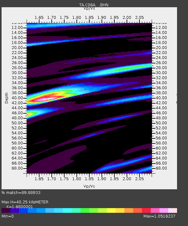
| Estimated Moho Depth: |
40.25 km |
| Estimated Crust Vp/Vs: |
1.68 |
| Assumed Crust Vp: |
6.597 km/s |
| Estimated Crust Vs: |
3.927 km/s |
| Estimated Crust Poisson's Ratio: |
0.23 |
|
| Radial Match: |
89.88933 % |
| Radial Bump: |
400 |
| Transverse Match: |
80.52443 % |
| Transverse Bump: |
400 |
| SOD ConfigId: |
2564 |
| Insert Time: |
2010-03-07 04:10:36.986 +0000 |
| GWidth: |
2.5 |
| Max Bumps: |
400 |
| Tol: |
0.001 |
|
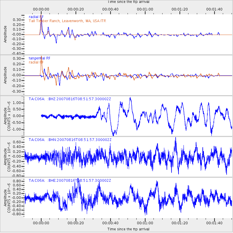
Signal To Noise
| Channel | StoN | STA | LTA |
| TA:C06A: :BHN:20070816T08:51:57.300002Z | 0.8813577 | 1.0166833E-7 | 1.1535421E-7 |
| TA:C06A: :BHE:20070816T08:51:57.300002Z | 1.2159748 | 1.2818836E-7 | 1.0542024E-7 |
| TA:C06A: :BHZ:20070816T08:51:57.300002Z | 3.6166108 | 2.9043963E-7 | 8.030713E-8 |
| Arrivals |
| Ps | 4.2 SECOND |
| PpPs | 16 SECOND |
| PsPs/PpSs | 20 SECOND |


