You are here: Home > Network List > TA - USArray Transportable Network (new EarthScope stations) Stations List
> Station C06A Tall Timber Ranch, Leavenworth, WA, USA > Earthquake Result Viewer
C06A Tall Timber Ranch, Leavenworth, WA, USA - Earthquake Result Viewer

| Earthquake location: |
Andreanof Islands, Aleutian Is. |
| Earthquake latitude/longitude: |
50.3/-177.5 |
| Earthquake time(UTC): |
2007/08/15 (227) 20:22:11 GMT |
| Earthquake Depth: |
9.0 km |
| Earthquake Magnitude: |
6.3 MB, 6.2 MS, 6.4 MW, 5.9 ML |
| Earthquake Catalog/Contributor: |
WHDF/NEIC |
|
| Network: |
TA USArray Transportable Network (new EarthScope stations) |
| Station: |
C06A Tall Timber Ranch, Leavenworth, WA, USA |
| Lat/Lon: |
47.92 N/120.89 W |
| Elevation: |
594 m |
|
| Distance: |
36.4 deg |
| Az: |
71.265 deg |
| Baz: |
295.508 deg |
| Ray Param: |
0.0767081 |
| Estimated Moho Depth: |
39.0 km |
| Estimated Crust Vp/Vs: |
1.65 |
| Assumed Crust Vp: |
6.597 km/s |
| Estimated Crust Vs: |
3.998 km/s |
| Estimated Crust Poisson's Ratio: |
0.21 |
|
| Radial Match: |
90.26012 % |
| Radial Bump: |
262 |
| Transverse Match: |
78.22673 % |
| Transverse Bump: |
400 |
| SOD ConfigId: |
2564 |
| Insert Time: |
2010-03-07 04:10:38.854 +0000 |
| GWidth: |
2.5 |
| Max Bumps: |
400 |
| Tol: |
0.001 |
|
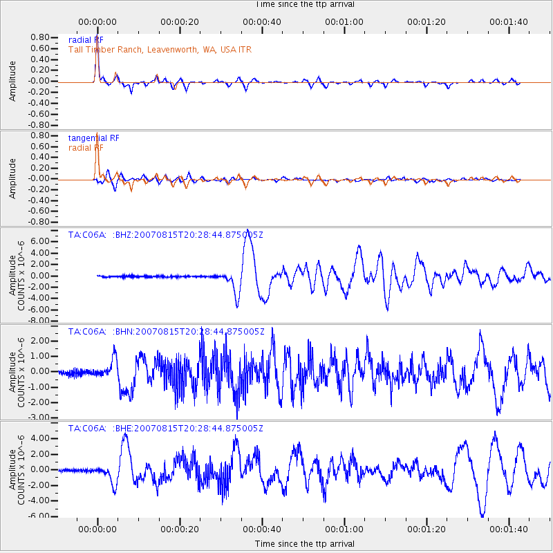
Signal To Noise
| Channel | StoN | STA | LTA |
| TA:C06A: :BHN:20070815T20:28:44.875005Z | 4.4793515 | 6.111318E-7 | 1.364331E-7 |
| TA:C06A: :BHE:20070815T20:28:44.875005Z | 10.519947 | 1.2103565E-6 | 1.15053474E-7 |
| TA:C06A: :BHZ:20070815T20:28:44.875005Z | 20.534422 | 2.1727244E-6 | 1.05808894E-7 |
| Arrivals |
| Ps | 4.2 SECOND |
| PpPs | 14 SECOND |
| PsPs/PpSs | 19 SECOND |


