You are here: Home > Network List > TA - USArray Transportable Network (new EarthScope stations) Stations List
> Station C06A Tall Timber Ranch, Leavenworth, WA, USA > Earthquake Result Viewer
C06A Tall Timber Ranch, Leavenworth, WA, USA - Earthquake Result Viewer
| Earthquake location: |
Near West Coast Of Honshu, Japan |
| Earthquake latitude/longitude: |
37.3/136.6 |
| Earthquake time(UTC): |
2007/03/25 (084) 00:41:57 GMT |
| Earthquake Depth: |
8.0 km |
| Earthquake Magnitude: |
6.1 MB, 6.8 MS, 6.7 MW, 6.6 MW |
| Earthquake Catalog/Contributor: |
WHDF/NEIC |
|
| Network: |
TA USArray Transportable Network (new EarthScope stations) |
| Station: |
C06A Tall Timber Ranch, Leavenworth, WA, USA |
| Lat/Lon: |
47.92 N/120.89 W |
| Elevation: |
594 m |
|
| Distance: |
70.7 deg |
| Az: |
44.088 deg |
| Baz: |
304.463 deg |
| Ray Param: |
0.0548208 |
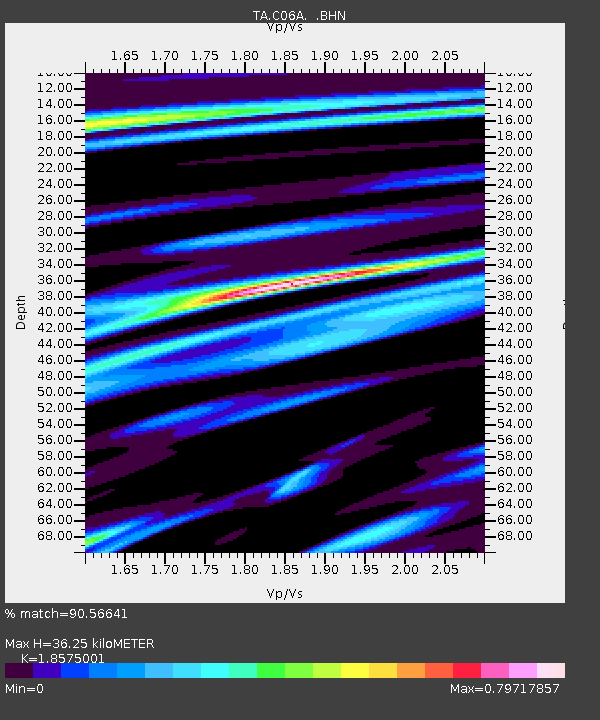
| Estimated Moho Depth: |
36.25 km |
| Estimated Crust Vp/Vs: |
1.86 |
| Assumed Crust Vp: |
6.597 km/s |
| Estimated Crust Vs: |
3.552 km/s |
| Estimated Crust Poisson's Ratio: |
0.30 |
|
| Radial Match: |
90.56641 % |
| Radial Bump: |
400 |
| Transverse Match: |
82.21211 % |
| Transverse Bump: |
400 |
| SOD ConfigId: |
2564 |
| Insert Time: |
2010-03-07 04:10:50.739 +0000 |
| GWidth: |
2.5 |
| Max Bumps: |
400 |
| Tol: |
0.001 |
|

Signal To Noise
| Channel | StoN | STA | LTA |
| TA:C06A: :BHN:20070325T00:52:42.775017Z | 3.0665054 | 1.0521377E-6 | 3.431064E-7 |
| TA:C06A: :BHE:20070325T00:52:42.775017Z | 5.4119415 | 1.8312197E-6 | 3.383665E-7 |
| TA:C06A: :BHZ:20070325T00:52:42.775017Z | 18.032513 | 4.4096387E-6 | 2.4453823E-7 |
| Arrivals |
| Ps | 4.9 SECOND |
| PpPs | 15 SECOND |
| PsPs/PpSs | 20 SECOND |


