You are here: Home > Network List > TA - USArray Transportable Network (new EarthScope stations) Stations List
> Station C06A Tall Timber Ranch, Leavenworth, WA, USA > Earthquake Result Viewer
C06A Tall Timber Ranch, Leavenworth, WA, USA - Earthquake Result Viewer
| Earthquake location: |
South Of Panama |
| Earthquake latitude/longitude: |
4.6/-78.5 |
| Earthquake time(UTC): |
2007/03/18 (077) 02:11:05 GMT |
| Earthquake Depth: |
8.0 km |
| Earthquake Magnitude: |
6.4 MB, 5.7 MS, 6.2 MW, 6.1 MW |
| Earthquake Catalog/Contributor: |
WHDF/NEIC |
|
| Network: |
TA USArray Transportable Network (new EarthScope stations) |
| Station: |
C06A Tall Timber Ranch, Leavenworth, WA, USA |
| Lat/Lon: |
47.92 N/120.89 W |
| Elevation: |
594 m |
|
| Distance: |
56.4 deg |
| Az: |
326.997 deg |
| Baz: |
126.172 deg |
| Ray Param: |
0.06419609 |
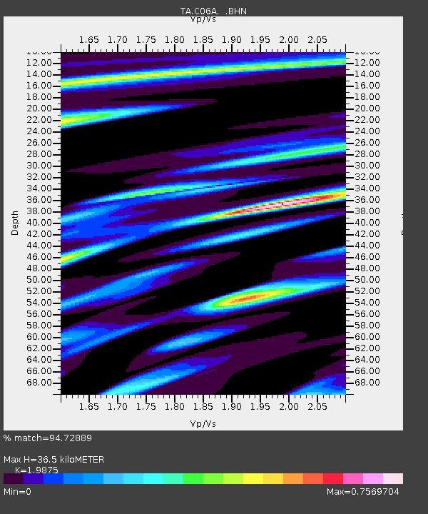
| Estimated Moho Depth: |
36.5 km |
| Estimated Crust Vp/Vs: |
1.99 |
| Assumed Crust Vp: |
6.597 km/s |
| Estimated Crust Vs: |
3.319 km/s |
| Estimated Crust Poisson's Ratio: |
0.33 |
|
| Radial Match: |
94.72889 % |
| Radial Bump: |
399 |
| Transverse Match: |
85.368195 % |
| Transverse Bump: |
400 |
| SOD ConfigId: |
2564 |
| Insert Time: |
2010-03-07 04:10:52.778 +0000 |
| GWidth: |
2.5 |
| Max Bumps: |
400 |
| Tol: |
0.001 |
|

Signal To Noise
| Channel | StoN | STA | LTA |
| TA:C06A: :BHN:20070318T02:20:15.950022Z | 5.0797844 | 9.690178E-7 | 1.9075965E-7 |
| TA:C06A: :BHE:20070318T02:20:15.950022Z | 8.075307 | 1.5821456E-6 | 1.9592389E-7 |
| TA:C06A: :BHZ:20070318T02:20:15.950022Z | 25.771677 | 3.9773563E-6 | 1.5433052E-7 |
| Arrivals |
| Ps | 5.7 SECOND |
| PpPs | 16 SECOND |
| PsPs/PpSs | 21 SECOND |


