You are here: Home > Network List > TA - USArray Transportable Network (new EarthScope stations) Stations List
> Station C06A Tall Timber Ranch, Leavenworth, WA, USA > Earthquake Result Viewer
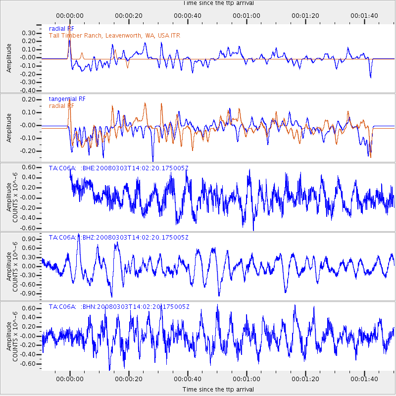
C06A Tall Timber Ranch, Leavenworth, WA, USA - Earthquake Result Viewer
*The percent match for this event was below the threshold and hence no stack was calculated.
| Earthquake location: |
Philippine Islands Region |
| Earthquake latitude/longitude: |
19.9/121.3 |
| Earthquake time(UTC): |
2008/03/03 (063) 13:49:40 GMT |
| Earthquake Depth: |
10 km |
| Earthquake Magnitude: |
6.0 MB, 6.0 MW, 5.9 MW |
| Earthquake Catalog/Contributor: |
WHDF/NEIC |
|
| Network: |
TA USArray Transportable Network (new EarthScope stations) |
| Station: |
C06A Tall Timber Ranch, Leavenworth, WA, USA |
| Lat/Lon: |
47.92 N/120.89 W |
| Elevation: |
594 m |
|
| Distance: |
92.5 deg |
| Az: |
36.564 deg |
| Baz: |
303.553 deg |
| Ray Param: |
$rayparam |
*The percent match for this event was below the threshold and hence was not used in the summary stack. |
|
| Radial Match: |
56.8006 % |
| Radial Bump: |
400 |
| Transverse Match: |
54.098797 % |
| Transverse Bump: |
400 |
| SOD ConfigId: |
2504 |
| Insert Time: |
2010-03-07 04:11:07.840 +0000 |
| GWidth: |
2.5 |
| Max Bumps: |
400 |
| Tol: |
0.001 |
|
Signal To Noise
| Channel | StoN | STA | LTA |
| TA:C06A: :BHZ:20080303T14:02:20.175005Z | 2.3012874 | 4.7010244E-7 | 2.0427801E-7 |
| TA:C06A: :BHN:20080303T14:02:20.175005Z | 0.6347943 | 1.13055385E-7 | 1.7809766E-7 |
| TA:C06A: :BHE:20080303T14:02:20.175005Z | 1.2096062 | 2.1378351E-7 | 1.7673813E-7 |
| Arrivals |
| Ps | |
| PpPs | |
| PsPs/PpSs | |


