You are here: Home > Network List > TA - USArray Transportable Network (new EarthScope stations) Stations List
> Station C06A Tall Timber Ranch, Leavenworth, WA, USA > Earthquake Result Viewer
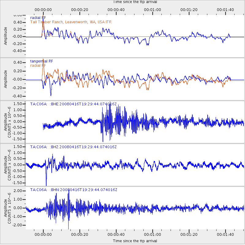
C06A Tall Timber Ranch, Leavenworth, WA, USA - Earthquake Result Viewer
*The percent match for this event was below the threshold and hence no stack was calculated.
| Earthquake location: |
Eastern Honshu, Japan |
| Earthquake latitude/longitude: |
39.0/140.0 |
| Earthquake time(UTC): |
2008/04/16 (107) 19:19:36 GMT |
| Earthquake Depth: |
166 km |
| Earthquake Magnitude: |
5.6 MB, 5.8 MW, 5.8 MW |
| Earthquake Catalog/Contributor: |
WHDF/NEIC |
|
| Network: |
TA USArray Transportable Network (new EarthScope stations) |
| Station: |
C06A Tall Timber Ranch, Leavenworth, WA, USA |
| Lat/Lon: |
47.92 N/120.89 W |
| Elevation: |
594 m |
|
| Distance: |
67.6 deg |
| Az: |
45.922 deg |
| Baz: |
303.703 deg |
| Ray Param: |
$rayparam |
*The percent match for this event was below the threshold and hence was not used in the summary stack. |
|
| Radial Match: |
26.324297 % |
| Radial Bump: |
400 |
| Transverse Match: |
48.3796 % |
| Transverse Bump: |
400 |
| SOD ConfigId: |
2504 |
| Insert Time: |
2010-03-07 04:11:12.001 +0000 |
| GWidth: |
2.5 |
| Max Bumps: |
400 |
| Tol: |
0.001 |
|
Signal To Noise
| Channel | StoN | STA | LTA |
| TA:C06A: :BHZ:20080416T19:29:44.074016Z | 3.4540434 | 4.3697466E-7 | 1.2651105E-7 |
| TA:C06A: :BHN:20080416T19:29:44.074016Z | 1.9153341 | 4.6113732E-7 | 2.4076078E-7 |
| TA:C06A: :BHE:20080416T19:29:44.074016Z | 2.5320911 | 5.252867E-7 | 2.0745173E-7 |
| Arrivals |
| Ps | |
| PpPs | |
| PsPs/PpSs | |


