You are here: Home > Network List > IC - New China Digital Seismograph Network Stations List
> Station HIA Hailar, Neimenggu Autonomous Region, China > Earthquake Result Viewer
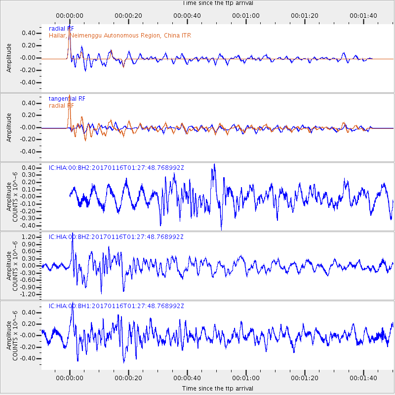
HIA Hailar, Neimenggu Autonomous Region, China - Earthquake Result Viewer
*The percent match for this event was below the threshold and hence no stack was calculated.
| Earthquake location: |
Vanuatu Islands |
| Earthquake latitude/longitude: |
-13.7/166.4 |
| Earthquake time(UTC): |
2017/01/16 (016) 01:16:38 GMT |
| Earthquake Depth: |
10 km |
| Earthquake Magnitude: |
5.8 mb |
| Earthquake Catalog/Contributor: |
NEIC PDE/us |
|
| Network: |
IC New China Digital Seismograph Network |
| Station: |
HIA Hailar, Neimenggu Autonomous Region, China |
| Lat/Lon: |
49.27 N/119.74 E |
| Elevation: |
620 m |
|
| Distance: |
74.9 deg |
| Az: |
330.452 deg |
| Baz: |
132.954 deg |
| Ray Param: |
$rayparam |
*The percent match for this event was below the threshold and hence was not used in the summary stack. |
|
| Radial Match: |
79.1054 % |
| Radial Bump: |
400 |
| Transverse Match: |
53.429096 % |
| Transverse Bump: |
400 |
| SOD ConfigId: |
1943534 |
| Insert Time: |
2017-01-30 01:17:42.635 +0000 |
| GWidth: |
2.5 |
| Max Bumps: |
400 |
| Tol: |
0.001 |
|
Signal To Noise
| Channel | StoN | STA | LTA |
| IC:HIA:00:BHZ:20170116T01:27:48.768992Z | 5.4061933 | 4.6670658E-7 | 8.632813E-8 |
| IC:HIA:00:BH1:20170116T01:27:48.768992Z | 3.1181576 | 2.3816315E-7 | 7.637944E-8 |
| IC:HIA:00:BH2:20170116T01:27:48.768992Z | 1.5018585 | 1.5855699E-7 | 1.0557385E-7 |
| Arrivals |
| Ps | |
| PpPs | |
| PsPs/PpSs | |


