You are here: Home > Network List > TA - USArray Transportable Network (new EarthScope stations) Stations List
> Station O01C Eel River Conservation Camp, Redway, CA, USA > Earthquake Result Viewer
O01C Eel River Conservation Camp, Redway, CA, USA - Earthquake Result Viewer
| Earthquake location: |
East Of Kuril Islands |
| Earthquake latitude/longitude: |
46.2/154.5 |
| Earthquake time(UTC): |
2007/01/13 (013) 04:23:21 GMT |
| Earthquake Depth: |
10 km |
| Earthquake Magnitude: |
7.3 MB, 8.2 MS, 8.1 MW, 7.9 MW |
| Earthquake Catalog/Contributor: |
WHDF/NEIC |
|
| Network: |
TA USArray Transportable Network (new EarthScope stations) |
| Station: |
O01C Eel River Conservation Camp, Redway, CA, USA |
| Lat/Lon: |
40.14 N/123.82 W |
| Elevation: |
138 m |
|
| Distance: |
57.4 deg |
| Az: |
64.268 deg |
| Baz: |
305.359 deg |
| Ray Param: |
0.06354658 |
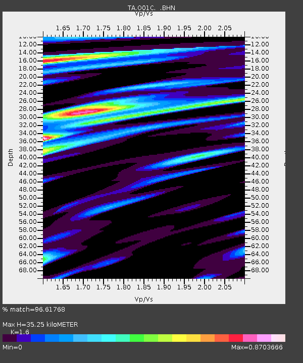
| Estimated Moho Depth: |
35.25 km |
| Estimated Crust Vp/Vs: |
1.60 |
| Assumed Crust Vp: |
6.566 km/s |
| Estimated Crust Vs: |
4.104 km/s |
| Estimated Crust Poisson's Ratio: |
0.18 |
|
| Radial Match: |
96.61768 % |
| Radial Bump: |
400 |
| Transverse Match: |
90.02405 % |
| Transverse Bump: |
400 |
| SOD ConfigId: |
2564 |
| Insert Time: |
2010-03-07 04:12:21.319 +0000 |
| GWidth: |
2.5 |
| Max Bumps: |
400 |
| Tol: |
0.001 |
|
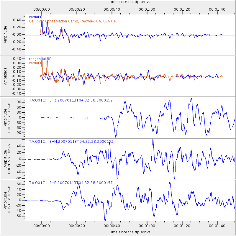
Signal To Noise
| Channel | StoN | STA | LTA |
| TA:O01C: :BHN:20070113T04:32:38.300015Z | 1.228885 | 7.970826E-7 | 6.486226E-7 |
| TA:O01C: :BHE:20070113T04:32:38.300015Z | 1.9851778 | 1.2191298E-6 | 6.141162E-7 |
| TA:O01C: :BHZ:20070113T04:32:38.300015Z | 3.6393557 | 2.699119E-6 | 7.416475E-7 |
| Arrivals |
| Ps | 3.4 SECOND |
| PpPs | 13 SECOND |
| PsPs/PpSs | 17 SECOND |


