
Station TA O01C - Eel River Conservation Camp, Redway, CA, USA
Network: TA - USArray Transportable Network (new EarthScope stations)
Nearby stations (2 deg radius)
| Station | Name | (Lat, Lon) | Start / End | Elevation |
| O01C | Eel River Conservation Camp, Redway, CA, USA | (40.14, -123.82) | 2005-08-25 / 2499-01-01 | 0.1 km |
| Crust2 Type: | L8,thin continental arc, Cordilleras, 0.5 km seds. |
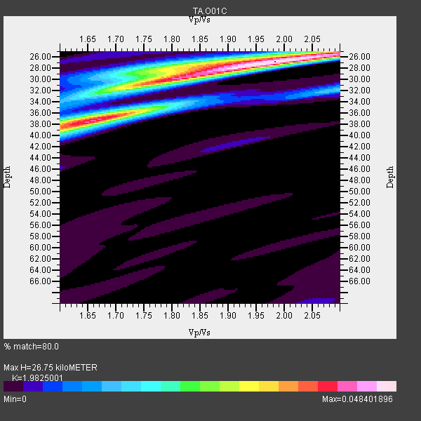
| Thickness Estimate: | 27 km |
| Thickness StdDev: | 4.1 km |
| Vp/Vs Estimate: | 1.98 |
| Vp/Vs StdDev: | 0.14 |
| Vs Estimate: | 3.312 km/s |
| Poisson's Ratio: | 0.33 |
| Peak Value: | 0.05 |
| Assumed Vp: | 6.566 km/s |
| Ps Weight: | 0.33333334 |
| PpPs Weight: | 0.33333334 |
| PsPs Weight: | 0.33333328 |
| Residual Complexity: | 0.647 |
| Nearby stations H: | +- |
| (2.0 deg) Vp/Vs: | +- |
9 with match > 90% ( 64.28571 %) and 14 with match > 80% ( 100.0 %) out of 14.
Download stack as xyz text file.
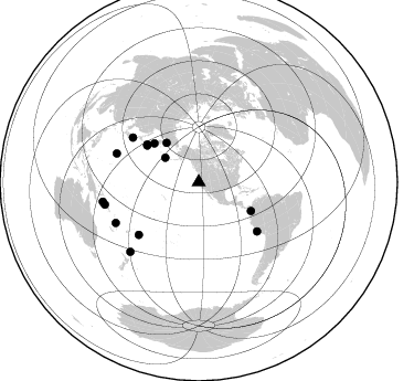
Azimuth Distribution of Events:
Prior Results for this Station
| Study | Thickness | Vp/Vs | Vp | Vs | Poissons Ratio | Extra |
| EARS | 27 km | 1.98 | 6.566 km/s | 3.312 km/s | 0.33 | |
| Crust2.0 | 34 km | 1.77 | 6.566 km/s | 3.707 km/s | 0.27 | L8,thin continental arc, Cordilleras, 0.5 km seds. |
| Global Maxima | 27 km | 1.98 | 6.566 km/s | 3.312 km/s | 0.33 | amp=0.048401896 |
| Local Maxima 1 | 37 km | 1.66 | 6.566 km/s | 3.956 km/s | 0.22 | amp=0.04026471 |
| Local Maxima 2 | 30 km | 1.78 | 6.566 km/s | 3.689 km/s | 0.27 | amp=0.031445544 |
| Local Maxima 3 | 27 km | 1.83 | 6.566 km/s | 3.583 km/s | 0.29 | amp=0.0167162 |
| Local Maxima 4 | 25 km | 2.10 | 6.566 km/s | 3.13 km/s | 0.35 | amp=0.008138077 |
| Predicted Arrivals for vertical incidence (zero ray parameter) | |
| Ps | 4.00 SECOND |
| PpPs | 12.15 SECOND |
| PsPs/PpSs | 16.15 SECOND |
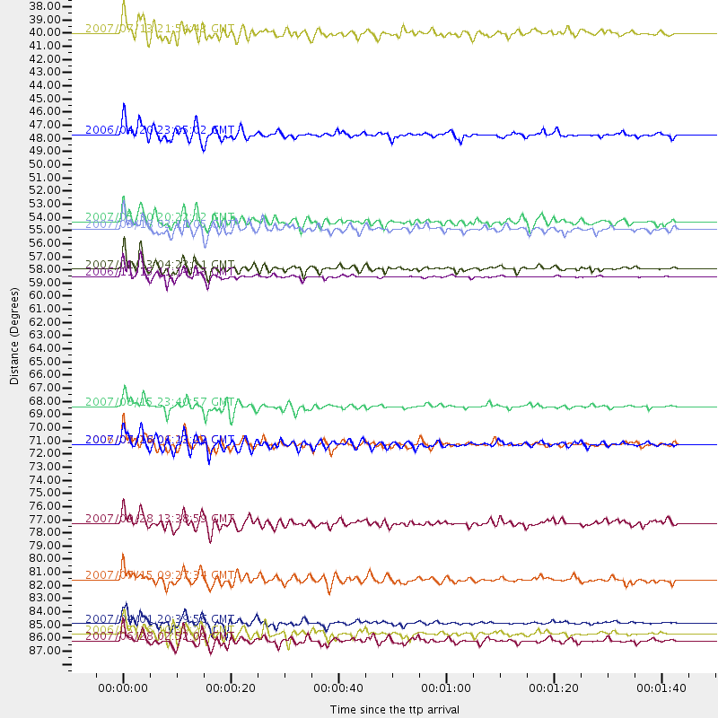
Events Processed for this Station
Download zip of receiver functions as SAC
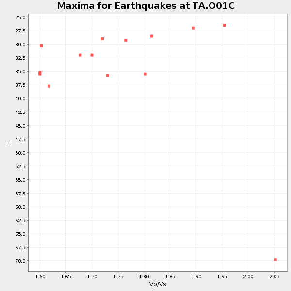
Plot maxima for each earthquake.
Events Used in the Stack
(14 events)| Radial Match | Distance | Baz | FERegion | Time | Lat/Lon | Depth | Magnitude |
| 98.61624 | 58.0 deg | 306.181 deg | Kuril Islands | 2006/11/15 11:14:13 GMT | (46.6, 153.3) | 10 km | 6.5 MB, 7.8 MS, 8.3 MW, 7.9 MW |
| 96.61768 | 57.4 deg | 305.359 deg | East Of Kuril Islands | 2007/01/13 04:23:21 GMT | (46.2, 154.5) | 10 km | 7.3 MB, 8.2 MS, 8.1 MW, 7.9 MW |
| 96.35427 | 87.2 deg | 256.583 deg | Solomon Islands | 2007/04/01 20:39:56 GMT | (-8.5, 157.0) | 10 km | 6.8 MB, 7.9 MS, 8.1 MW, 7.7 ME |
| 92.86798 | 72.1 deg | 304.122 deg | Near West Coast Of Honshu, Japan | 2007/07/16 01:13:22 GMT | (37.5, 138.4) | 12 km | 6.5 MB, 6.4 MS, 6.6 MW, 6.5 MW |
| 92.59752 | 88.1 deg | 224.605 deg | Kermadec Islands Region | 2006/05/16 10:39:23 GMT | (-31.8, -179.3) | 152 km | 6.8 MB, 7.4 MW, 7.4 MW |
| 91.57284 | 69.0 deg | 130.07 deg | Near Coast Of Peru | 2007/08/15 23:40:57 GMT | (-13.4, -76.6) | 39 km | 6.7 MB, 7.9 MS, 8.0 MW, 7.5 ME |
| 91.08285 | 78.7 deg | 289.183 deg | Volcano Islands, Japan Region | 2007/09/28 13:38:59 GMT | (22.0, 142.7) | 276 km | 6.7 MB, 7.4 MW, 7.4 MW |
| 90.87868 | 46.1 deg | 320.709 deg | Eastern Siberia, Russia | 2006/04/20 23:25:02 GMT | (60.9, 167.1) | 22 km | 6.8 MB, 7.6 MS, 7.6 MW, 7.3 MW |
| 90.509964 | 53.4 deg | 311.09 deg | Kamchatka Peninsula, Russia | 2007/05/30 20:22:12 GMT | (52.1, 157.3) | 116 km | 6.4 MB, 6.4 MW, 6.4 MW |
| 88.79227 | 88.7 deg | 258.516 deg | Solomon Islands | 2007/06/28 02:52:09 GMT | (-8.0, 154.6) | 10 km | 6.3 MB, 6.7 MS, 6.7 MW, 6.7 MW |
| 87.89678 | 72.1 deg | 228.712 deg | Samoa Islands Region | 2006/09/28 06:22:09 GMT | (-16.6, -172.0) | 28 km | 6.5 MB, 6.6 MS, 6.9 MW, 6.7 MW |
| 87.052574 | 54.0 deg | 118.774 deg | South Of Panama | 2007/03/18 02:11:05 GMT | (4.6, -78.5) | 8.0 km | 6.4 MB, 5.7 MS, 6.2 MW, 6.1 MW |
| 83.19768 | 37.5 deg | 306.077 deg | Andreanof Islands, Aleutian Is. | 2007/07/13 21:54:43 GMT | (51.8, -176.3) | 35 km | 5.7 MB, 5.6 MS, 6.0 MW, 5.9 MW |
| 81.57424 | 83.5 deg | 243.826 deg | Vanuatu Islands | 2007/07/15 09:27:34 GMT | (-15.4, 168.6) | 8.0 km | 6.0 MB, 5.8 MS, 6.1 MW, 6.0 MW |
Losers
(0 events)| Radial Match | Distance | Baz | FERegion | Time | Lat/Lon | Depth | Magnitude | Reason |
