You are here: Home > Network List > TA - USArray Transportable Network (new EarthScope stations) Stations List
> Station O01C Eel River Conservation Camp, Redway, CA, USA > Earthquake Result Viewer
O01C Eel River Conservation Camp, Redway, CA, USA - Earthquake Result Viewer
| Earthquake location: |
Kuril Islands |
| Earthquake latitude/longitude: |
46.6/153.3 |
| Earthquake time(UTC): |
2006/11/15 (319) 11:14:13 GMT |
| Earthquake Depth: |
10 km |
| Earthquake Magnitude: |
6.5 MB, 7.8 MS, 8.3 MW, 7.9 MW |
| Earthquake Catalog/Contributor: |
WHDF/NEIC |
|
| Network: |
TA USArray Transportable Network (new EarthScope stations) |
| Station: |
O01C Eel River Conservation Camp, Redway, CA, USA |
| Lat/Lon: |
40.14 N/123.82 W |
| Elevation: |
138 m |
|
| Distance: |
58.0 deg |
| Az: |
63.799 deg |
| Baz: |
306.181 deg |
| Ray Param: |
0.06314308 |
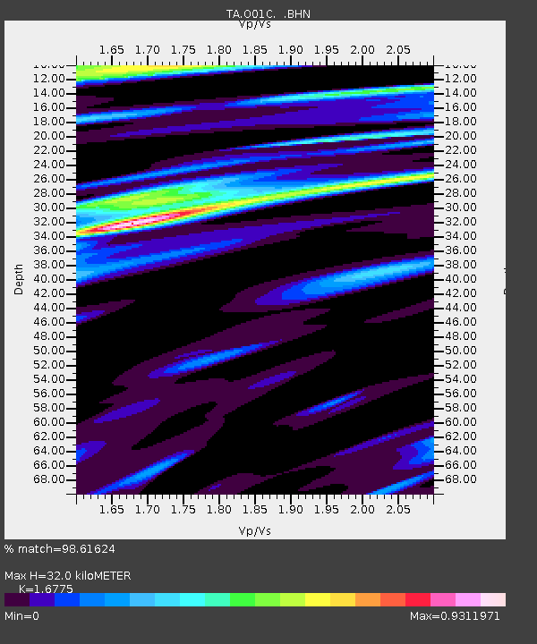
| Estimated Moho Depth: |
32.0 km |
| Estimated Crust Vp/Vs: |
1.68 |
| Assumed Crust Vp: |
6.566 km/s |
| Estimated Crust Vs: |
3.914 km/s |
| Estimated Crust Poisson's Ratio: |
0.22 |
|
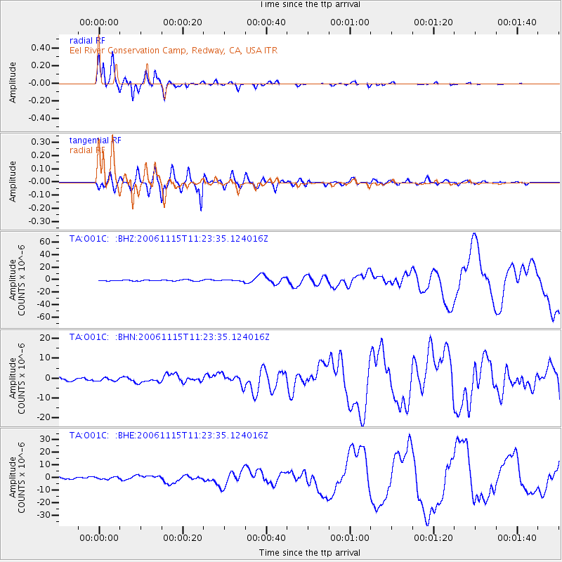
| Radial Match: |
98.61624 % |
| Radial Bump: |
229 |
| Transverse Match: |
88.21463 % |
| Transverse Bump: |
400 |
| SOD ConfigId: |
2564 |
| Insert Time: |
2010-03-07 04:12:23.175 +0000 |
| GWidth: |
2.5 |
| Max Bumps: |
400 |
| Tol: |
0.001 |
|
Signal To Noise
| Channel | StoN | STA | LTA |
| TA:O01C: :BHN:20061115T11:23:35.124016Z | 1.0117903 | 7.324349E-7 | 7.238999E-7 |
| TA:O01C: :BHE:20061115T11:23:35.124016Z | 0.97404283 | 8.254053E-7 | 8.4740145E-7 |
| TA:O01C: :BHZ:20061115T11:23:35.124016Z | 1.405044 | 1.1237197E-6 | 7.997754E-7 |
| Arrivals |
| Ps | 3.5 SECOND |
| PpPs | 12 SECOND |
| PsPs/PpSs | 16 SECOND |


