You are here: Home > Network List > TA - USArray Transportable Network (new EarthScope stations) Stations List
> Station O01C Eel River Conservation Camp, Redway, CA, USA > Earthquake Result Viewer
O01C Eel River Conservation Camp, Redway, CA, USA - Earthquake Result Viewer
| Earthquake location: |
Samoa Islands Region |
| Earthquake latitude/longitude: |
-16.6/-172.0 |
| Earthquake time(UTC): |
2006/09/28 (271) 06:22:09 GMT |
| Earthquake Depth: |
28 km |
| Earthquake Magnitude: |
6.5 MB, 6.6 MS, 6.9 MW, 6.7 MW |
| Earthquake Catalog/Contributor: |
WHDF/NEIC |
|
| Network: |
TA USArray Transportable Network (new EarthScope stations) |
| Station: |
O01C Eel River Conservation Camp, Redway, CA, USA |
| Lat/Lon: |
40.14 N/123.82 W |
| Elevation: |
138 m |
|
| Distance: |
72.1 deg |
| Az: |
36.922 deg |
| Baz: |
228.712 deg |
| Ray Param: |
0.0538574 |
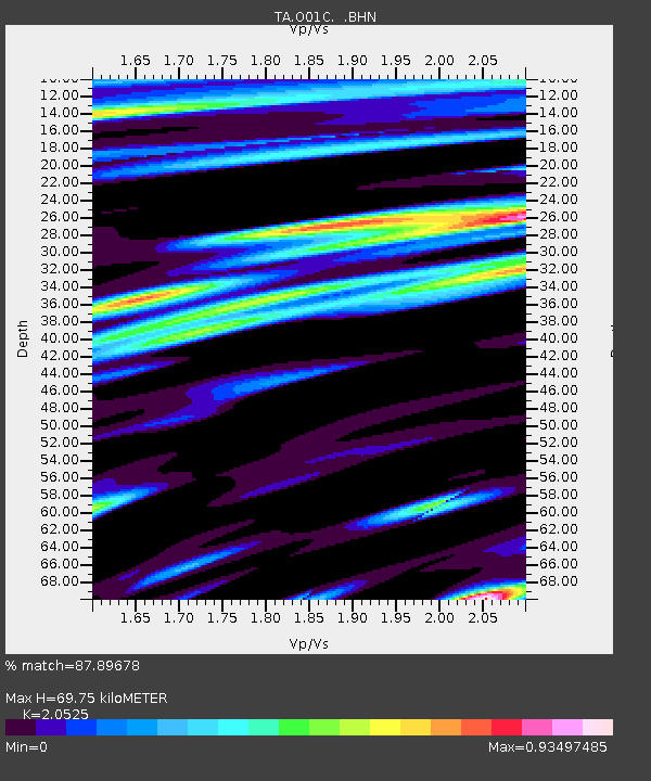
| Estimated Moho Depth: |
69.75 km |
| Estimated Crust Vp/Vs: |
2.05 |
| Assumed Crust Vp: |
6.566 km/s |
| Estimated Crust Vs: |
3.199 km/s |
| Estimated Crust Poisson's Ratio: |
0.34 |
|
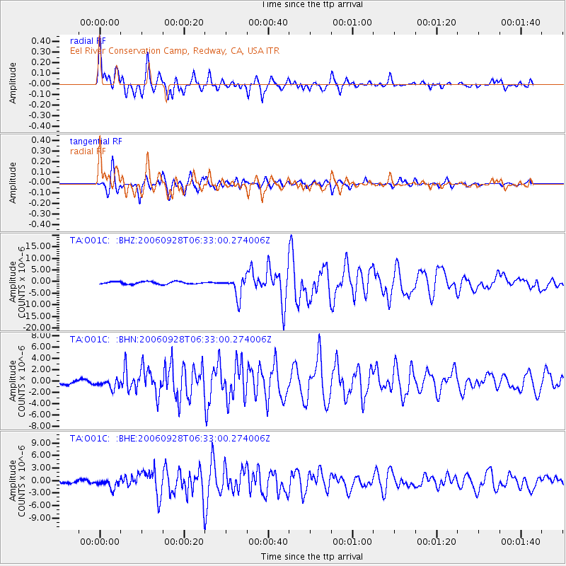
| Radial Match: |
87.89678 % |
| Radial Bump: |
400 |
| Transverse Match: |
90.146645 % |
| Transverse Bump: |
400 |
| SOD ConfigId: |
2665 |
| Insert Time: |
2010-03-07 04:12:25.977 +0000 |
| GWidth: |
2.5 |
| Max Bumps: |
400 |
| Tol: |
0.001 |
|
Signal To Noise
| Channel | StoN | STA | LTA |
| TA:O01C: :BHN:20060928T06:33:00.274006Z | 2.1451154 | 8.332891E-7 | 3.884589E-7 |
| TA:O01C: :BHE:20060928T06:33:00.274006Z | 4.880069 | 1.1026607E-6 | 2.2595187E-7 |
| TA:O01C: :BHZ:20060928T06:33:00.274006Z | 8.271924 | 4.497759E-6 | 5.43738E-7 |
| Arrivals |
| Ps | 12 SECOND |
| PpPs | 31 SECOND |
| PsPs/PpSs | 43 SECOND |


